Download
1 / 42
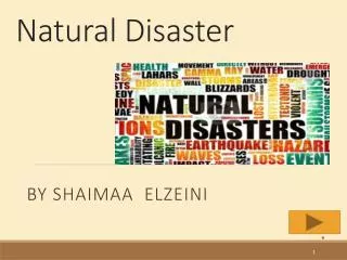
420 likes | 492 Vues
Badaoui Rouhban Director Section for Disaster Reduction Natural Sciences Sector UNESCO. Nombre de désastres naturels, évolution par continent: 1950-2008.

E N D
Badaoui Rouhban Director Section for Disaster Reduction Natural Sciences Sector UNESCO
Nombre de désastres naturels, évolution par continent: 1950-2008 Source: “EM-DAT: The OFDA/CRED International Disaster Database – www.emdat.net – Université Catholique de Louvain – Brussels – Belgium.”
Désastres Naturels dans les Pays Méditerranée1989-2008 (After CRED, Belgium) Nombre de désastres naturels 1989-2008 Source: “EM-DAT: The OFDA/CRED International Disaster Database – www.emdat.net – Université Catholique de Louvain – Brussels – Belgium.”
Impact humaine des désastres naturels: 1989-2008(After CRED, Belgium) Nombre de morts Nombre d’affectés Source: “EM-DAT: The OFDA/CRED International Disaster Database – www.emdat.net – Université Catholique de Louvain – Brussels – Belgium.”
Coastal zone is particularly at risk • 1.2 billion people live within 100 km from the coast. • This is 23% of the world population. In 2030 this figure may rise to 50%. • Half of worlds GDP is in the coastal urban areas. This figure will increase to 75% in 2015.(World Bank) • More than half of GDP is located in high risk areas. (World bank) • 10 million peoble experience flooding each year due to storm surges and typhoons. • Tsunamies, floods, storm surges, typhoons continue to happen in the coastal area and climate change is expected worsen the situation.
CATASTROPHES PROVOQUEES HOMME NATURELLES SOUDAINES LENTES ENVIRONMENTALLES TECHNOLOGIQUES - Seismes - Eruptions volcaniques - Inondations - Glissements de terrain - Tempetes, cyclones, ouragans - Changements climatiques, rechauffement - Desertification, secheresse - Changements climatiques - Deforestation (Amazonie) - Developpement megapoles - Disparition lacs ( mer Aral) - Chimiques (Bhopal, AZF) - Nucleaires (Tchernobyl) - Maree noires (Exxon Valdez, Erika, Prestige) INTERACTIONS, COMPLEXITE
HAZARD VULNERABILITY RISK x = V R H x =
The United Nations system engaged in disaster reduction World Meteorological Organization WORLD BANK
United Nations International Strategy For Disaster Reduction (ISDR) Secretariat based in Geneva
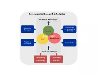
Hyogo Framework for Action • Governance; • Risk identification, assessment, monitoring and early warning; • Knowledge management and education; • Reducing underlying risk factors; • Preparedness for effective response and recovery.
UNESCO’s role • Identification of Hazards and Risks • Monitoring, Mapping, Risk Assessment • Promotion of Preventive and Mitigation Measures • Promotion of early warning systems • Building capacities and training of scientists and engineers • Educating and raising awareness for disaster preparedness • Guidelines for the protection of educational buildings, cultural sites • Environmental consideration
UNESCO programmes in Disaster Reduction • Natural hazards programme • International Geoscience Programme (IGCP) • lnternational Hydrological Programme (IHP) • Man and Biosphere (MAB) Programme • Programmes of UNESCO’s lntergovernmental Oceanographic Commission (IOC) • Protection of Cultural Heritage • UN Decade on Education for Sustainable Development
Accomplishments • Institute of Earthquake Engineering and Engineering Seismology of Skopje – former Yugoslav Republic of Macedonia (IZIIS) • Regional Centre for Seismology for South America – Peru (CERESIS) • Pacific Tsunami Warning System • International Institute of Seismology and Earthquake Engineering - Japan (IISEE) • International Seismological Centre - UK (ISC) • Centre de Génie Parasismique - Algeria • International Institute of Earthquake Engineering and Seismology – Iran • UNESCO-IHE for Water Education- Netherlands
Programme for Assessment and Mitigation of Earthquake Risk in the Arab Region (PAMERAR) 1983 - Algeria Egypt Irak Jordan Lebanon Libya Morocco Syria Tunisia Sudan
PAMERAR results Capacity building for earthquake risk reduction more than 3500 person-days of training provided for scientists, engineers and technicians, more than 40 missions of technical assistance organizedDevelopment of seismic networks300 seismometers and accelerometers installed in Morocco, Tunisia, Iraq, Yemen, Jordan, Syria and Egypt Earthquake provisions to building codesin Algeria, Jordan, Morocco and Tunisia
Earthquakes • UNESCO/USGS Programme on Reducing Earthquake Losses in the Enlarged Mediterranean Region (RELEMR); • UNESCO/USGS Programme on Reducing Earthquake Losses in the South Asia Region (RELSAR);
REDUCING EARTHQUAKE LOSSES IN THE EASTERN MEDITERRANEAN REGION (RELERM) • Algeria • Cyprus • Egypt • Greece • Israel • Iran • Jordan • Lebanon • Lybia • Palestinian Authority • Morocco • Oman • Saudi Arabia • Spain • Syria • Tunisia • Turkey • United States • Yemen
REDUCING EARTHQUAKE LOSSES IN THE SOUTH ASIA REGION (RELSAR) • Afghanistan • Bangladesh • Bhutan • China • India • Iran • Nepal • Pakistan • The Philippines • Sri Lanka • United States
INTERNATIONAL PLATFORM FOR REDUCING EARTHQUAKE DISASTER (IPRED) • Chile • Egypt • Indonesia • Japan (CoE) • Kazakhstan • A research and training platform based on seismology and earthquake engineering • A system for post-earthquake field investigation • Mexico • Peru • Romania • Turkey • + IPRED is supported by the Ministry of Land, Infrastructure, Transport and Tourism (MLIT) of Japan 1st IPRED meeting, Paris, 2008
Tsunami Warning and Mitigation Systems IOC of UNESCO
Landslides • Promotion of the International Consortium on Landslides (ICL) and the International Programme on Landslides (IPL) • Promotion of various studies on the cause and prevention of landslides Leyte, Philippines, 2006 Barcelona, Spain, 2006
UNESCO addressing hydrological extremes IFI: International Flood Initiative International Centre for Water Hazard and Risk Management under the auspices of UNESCO (UNESCO-ICHARM, Tsukuba, Japan) IIASA
Flood risk management “RIMAX – Risk Management of Extreme Flood Events” UNESCO Technical Document • Cooperation between German IHP National Committee and UNESCO IHP • Revealing the current state of research and technology • Topics • Topic 1: Forecast and warning • Topic 2: Forecast – dykes • Topic 3: Management in disaster situations • Topic 4: Damage assessment and society
Flood activities of FRIEND (Flow Regimes from International Experimental Network and Data Sets) Techniques for extreme rain fall and flood runoff estimate Flood forecasting hydrological processes linked with heavy rains Methodologies for reliable inundation mapping through flood risk maps and vulnerability maps. Stochastic modelling of heavy precipitation for runoff forecasting Enhanced understanding forecasting and management of flash floods in urban areas Tools for warning and forecasting of ungauged basins
UNESCO and IAHS joint compendium of extreme flood events (20 extreme events) Aim of the monograph: to give information on the causes, the evolution and the flood damage.
UNESCO-IHEactivities on flood risk management • Flood resilience • Floating buildings • Redesigning urban areas • Flood warning • Developing flexible, appropriate software tools for real- time flood prediction • Examining the effect of climate on flood prediction tools • Using SMS messaging to deliver flood warning by location
Drought/desertification • The Man and Biosphere Programme (MAB) • The International Hydrological Programme (IHP)
Water Cycle and Drought Monitoring over Africa The International Hydrological Programme (IHP) supports the Land Surface Hydrology Group of Princeton University in the development of an experimental, near real-time drought monitor in Africa.
Risk mapping, El Salvador, UNESCO RAP-CA project Floods, landslides “RISK ANALYSIS OF FLOODS AND LANDSLIDES IN THE ARENAL DE MONTSERRAT SUB-BASIN, EL SALVADOR” Landslide, 13 January 2001 Map showing population density within the sub-basin Floods, 2000, 2002
Protection of educational buildingsand cultural heritage Landslides, Machu Pichu, Peru International Programme on Landslides supported by UNESCO
Environmental Protection To strengthen environmental protection for the prevention of natural disasters Planting a tree, St Vincent in the Grenadines, 2003 UNESCO CSI project
UNESCO’s post-disaster studies In the aftermath of disaster, to foster post-disaster investigation, recovery and rehabilitation UNESCO post earthquake mission, Bam, Iran 2003
2005-2015 • Hyogo Framework for Action2005-2015 – Building Resilient Communities • United Nations Decade of Education for Sustainable Development 2005-2015
UN-ISDR • (International Strategy for Disaster Reduction) Thematic Platform on Knowledge and Education • UNESCO is one of the active agencies • Creation of a forum to exchange knowledge; • Dissemination of good practices andexamples; • Mainstreaming of disaster risk reduction into school curricula • and school safety.
School Curricula Today • Many focus on science • Many focus on preparedness & drills • Few integrate the two • Fewer develop their own local curriculum • Far fewer GO OUTSIDE and study the school’s hazards & the communities
What is education for disaster reduction? • A new vision of education • An education empowering people to commit themselves • An education at all levels of education systems, using all modalities, and in all social contexts
Maldives • Global population : 298 000 • Student population : 102 000 • At least 1 school per island • 334 schools per 200 islands • 40 % of the population in schools.
Upcoming major events • Second session of the Global Platform for Disaster Risk Reduction, • 15-19 June 2009 in Geneva, Switzerland