Download
1 / 17
180 likes | 320 Vues
Chamela LTER, Pacific Coast of Jalisco, México. 4/Sep/01. Proyecto “Cuencas” (1981- present). Chamelas’ Experimental Watersheds. N. 180. 160. 140 m.a.s.l. 120. Ws-I. Ws-III. 100. Ws-II. Ws-V. Ws-IV. 80. 60. Eje Central. Arroyo Zarco. Camino Antiguo. 1 km.

E N D
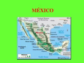
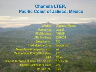
Chamela LTER, Pacific Coast of Jalisco, México
4/Sep/01 Proyecto “Cuencas” (1981- present)
Chamelas’ Experimental Watersheds N 180 160 140 m.a.s.l. 120 Ws-I Ws-III 100 Ws-II Ws-V Ws-IV 80 60 Eje Central Arroyo Zarco Camino Antiguo 1 km Estación de Biología
Colectores de lluvia indirecta Colectores de hojarasca Medición en troncos Cuadros permanentes de medición
Parámetro Unidades Alto Medio Bajo Geomorfología Superficie censada m² 2100 2400 2400 Elevación msnm 150 130 70 Profundidad de suelos cm 40-45 15-25 20-30 Intervalo de pendientes grados 8-16 8-16 16-30 Hidrología Area de la cuenca ha 14.91 Pendiente del cauce % 15.5 Longitud del cauce Km 0.48 Volumen de escorrentia m³/año 6316 Lámina de escorrentía mm/año 42.36 % de lluvia anual escurrida % 4.65 Florística Diversidad spp/cuadro 57 78 88 Núm. de spp con 50% del VIP spp 11 11 12 VIP Acumulado en 10 spp % 47.9 49.2 46.5 Especie más importante Guapira lin. Guapira lin. Thouinid. d. 2° " Plumeria ru. Lonch. erio. Guapira lin. 3° " Lonch. cons. Plumeria ru. Astronium g. 4° " Bursera inst. Pityrocar. c. Trichilia tri. 5° " Colubr. het. Bursera inst. Casearia c. Estructura Area Basal AP Promedio cm² 45.5 53.5 93.9 Area Basal AP Mámima cm² 695.7 3921.9 2246.0 Area Basal m²/cuadro 3.43 4.38 4.85 Area Basal m²/ha 16.33 18.23 20.22 Altura promedio m 5.1 4.9 6.2 Altura Máxima m 9.0 14.0 25.0 Perímetro AP promedio cm 20.9 21.8 27.0 Perímetro AP Máxima cm 93.5 222.0 168.0 Altura de la copa promedio m 3.7 4.0 4.8 Altura máxima de la copa m 7.5 12.0 22.0 Radio de la copa promedio m 1.3 0.8 1.5 Radio máximo de la copa m 7.0 3.5 9.9 Densidad Ind/cuadro 752 815 516 Densidad Ind/ha 3581 3396 2150 Resumen de parámetros de la Cuenca I
Parámetro Unidades Alto Medio Bajo Productividad Area Foliar Específica cm²/g 154 188 203 Indice de Area Foliar m²/m² 3.3 3.8 5.4 Caída de hojarasca kg/(ha*año) 3291.0 3191.0 4210.0 PPN-Aérea kg/(ha*año) 6680 6396 8145 PPN-Subterránea kg/(ha*año) 5313 5243 5476 PPN-Total kg/(ha*año) 11993 11639 13621 Mantillo en pie (total) Kg/ha 8188 7933 7996 Ramas en el mantillo Kg/ha 4522 4174 3932 Hojas en el mantillo Kg/ha 2936 3264 3346 Estr. Repr. en el mantillo Kg/ha 369 219 216 Restos animales en mant. Kg/ha 38 30 74 Crecimiento Incremento en diámetro cm/ind 0.2 0.19 0.29 Incremento en perímetro cm/ind 0.65 0.77 1.02 Incremento en área basal cm²/ind 2.55 2.78 4.95 Incr. en biomasa leñosa kg/ind 0.72 0.71 1.38 Incr. en biomasa leñosa kg/(ha*año) 27 21 102 Biogeoquímica Materia Orgánica del Suelo % 2.0-2.5 2.5-3.0 3.0-3.5 Profundidad de suelos cm 40-45 15-25 20-30 Descomp. del mantillo Constante k 0.46 0.36 0.46 N Total % 0.13 0.14 0.23 P Extractable PPM 8.83 8.99 28.21 K extractable meq 100/g 0.78 0.86 0.84 Ca extractable meq 100/g 6.38 6.29 10.61 Mg extractable meq 100/g 2.09 1.97 2.63 Resumen de parámetros de la Cuenca I
Potential Vegetation Tropical Evergreen Forest Tropical Subdecid. Forest Tropical Deciduous Forest Thorn Forest Xerophytic Shrubs & Desrts Grasslands Pine Forest Cloud Forest Aquatic vegetation 20o N Chamela MAASS 2/03
800 Wettest year (1,261 mm) 700 600 500 Yearly average (763 mm) 400 Monthly values 300 200 Driest year (366 mm) 100 0 J F M A M J J A S O N D Monthly Rainfall in Chamela, Jalisco, Mexico rainfall (mm)
Rainy Season in the TDF of Chamela, Jal. Mex. 7.5 Feb Jan Dec Nov 3 Oct Sep Aug Jul Jun May 83 84 85 86 87 88 89 90 91 92 93 94 95 96 97 98 99 00 MAASS 6/03
Southern Oscillation Index Rainfall (mm) Runoff (mm) 200 Max Discharge (m3 s-1km-2) 1200 150 1.0 1000 10 0.75 100 800 5 0.5 50 600 0.25 0 400 0 0 -5 -10 83 84 85 86 87 88 89 90 91 92 93 94 95 96 97 Effects of the El Niño Southern Oscillation in the Chamela Region(Maass et al.) MAASS 6/03
500 450 400 Hojarasca (g m-2 a-1 ± 1EE) 350 300 82 84 86 88 90 92 94 96 98 Producción de Hojarasca en la Selva Baja Caducifolia de Chamela, Jalisco (Martínez Yrízar et al.)
Temporal Variation of Standing-crop Leaf-litter In the Tropical Deciduous Forest of Chamela, Jal. (After Martínez-Yrízar et al.) 1000 900 800 700 Dry Weight (g m-2) 600 500 400 300 200 82 83 84 85 86 87 88 89 90 91 92 93 94 95 96
1998: 1261 mm 1999: 1131 mm Soil Moisture during wet years in a Tropical Deciduous Forest in Chamela, Jalisco, Mexico (Data: García Oliva et al.) 0.30 Wet Years 0.25 0.20 Soil Moisture (%) 0.15 0.10 0.05 0.00 Nov Jun Jul Aug Sep Oct
Soil Moisture during dry years in a Tropical Deciduous Forest in Chamela, Jalisco, Mexico (Data: García Oliva et al.) 0.30 2000: 545 mm Dry Years 2001: 440 mm 0.25 2002: 649 mm 0.20 Soil Moisture (%) 0.15 0.10 0.05 0.00 Jun Jul Aug Sep Oct Nov Dec
TDFt TDFtu TSF -p se sa-r se -r TDFs -p -r TDFtr -p ma-r TSFu chbw se ma-r cbw Cb TDFm TDFsu TSFm slb ll CP Pb ia-r Cg Cd h slbw C slb ll Ch Pg Pd P sl d Pc ia-r ia-v d T5 sa-r sa-r chbw T5 cbw TSFy TDFy ia-r ia-v sa-p sa-p T10 T10 ma-p chb ma-p T20 U T20 la-r la-r la-p la-p Burgos and Maass TDF Flatlands Crests Slopes
Grado de amenaza ponderado 0.00 0.10 0.20 0.30 0.40 0.50 0.60 0.70 0.80 0.90 Pradera de temporal Agricultura temporal G. vacuno (sin tumbar) Extracción de especies G. caprino (sin tumbar) Asentamientos urbanos Incendios provocados Extracción maderable Minería Asentamientos rurales Extracción no maderable Plantaciones forestales Agricultura tecnificada Presas Caminos Agricultura transhumante Líneas eléctricas Introducción de especies Acuacultura Gasoducto Desvío de agua Matarrasa Sobreexpl. de acuíferos Local Nacional Regional
Bosque tropical sub-caducifolio (arroyos) Monitoreo a largo plazo de riqueza de especies de reptiles en dos ambientes de selva seca en Chamela, Jalisco (Andrés García et al.) 50 30 Bosque tropical caducifolio 10 Riqueza Acumulada Número de muestreos 10 20 30 40 50 -10 -30 -50 6 años