Download
1 / 21
210 likes | 226 Vues
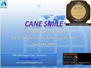
CANE SMILE Smart Application of Geo -Spatial technologies for Sugarcane. Mitr Phol Sugar Corp., Thailand www.mitrphol.com saravananr@mitrphol.com. Contents of presentation. Thailand Sugar industry Background of Mitr Phol Sugarcane management process Why Geo -spatial informations

E N D
CANE SMILE Smart Application of Geo-Spatial technologies for Sugarcane MitrPholSugar Corp., Thailand www.mitrphol.com saravananr@mitrphol.com
Contents of presentation • ThailandSugarindustry • Background of MitrPhol • Sugarcane management process • WhyGeo-spatial informations • Applications and benefits to business and farming • Conclusion
Thailand Sugar industry – A glance • 47 sugarfactories • 4thlargestproducerglobally • 2ndlargest exporter (Exports 70% of production ; 5-6 million tons) • 1.1 million ha cane area • 65-75 million ton cane • Daily crushing 825,000 Tons • Crushingperiod 120 days • 6.5 – 7.5 million ton Sugar
Mitr Phol Sugar and allied Business Since 1946 • Largest in Thailand (19 % share) and one of the pioneers in Asia and global • Produces 2.55 million tons of sugar annually
Mitr Phol Sugar operations China Lao Thailand
Sugar industry – A Zero waste 2 3 Sugar Cane 7 Bagasses Board 1 Sugar Mill 4 5 Fertilizer 6 Cogeneration Ethanol
Sugarcane Farming background • Contract farming • Averagefarm size 2.5 ha • 85% cane area depend on rain • Low cane yield compared to Brazil, Australia and India. • Less intensive farming • Soils low in organic matter • Uncertain rainfall- amount and distribution • Farmers have choices of growing different crops
Cane Management Operations • Land survey for cane area expansion • Contract agreement with farmers • Monitor cane planting area • Arranging finance loan • Deliver fertilizer • Monitor crop condition • Harvest planning • Cane supply logistics – field to factory
Manual documentation • Time : more time taken for reporting and decision making • Accuracy: less accurate • Human resource : More time spent • Cost : spent more Costly ,Time consuming and less accurate
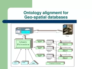
Geo-Spatial information System • Map accurate cane area at parcel level and estimate cane production. • Deliver finance and inputs to farmers in time • Manage field operations- planning and monitoring in more efficient manner. • Determine suitable area for cane expansion • Yield improvement through site specific problem analysis O B J E C T I V E S
Cane Smile Geo-Spatial information System Soil map Satellite INFO. FLOW Road Land use Nutrient map A P P L I C A T I O N Planning GPS Survey Data collection Monitoring Farmer & Farm data Crop improvement
Accurate area estimation GIS Map Field sketch
Quick finance and inputs to farmers • Field map, area and planting is verified • Request for farm loan is approved online • Release of loan reduced to 3 days from 19 days
Quick retrieval of information • Planting area • Loan status • Fertilizer and crop management • Harvest planning and monitoring
Cane area expansion Irrigation potential area Pond, river, canal, bore well Rainfed potential area Scrub land, fallow, upland rice Land use map Water resource Soil suitability map 30 Km Suitable area for expansion
Crop condition monitoring NDVI map Monitoring the impact of drought and anomalies to map the hot spot area Satellite image Dry cane Green cane
Zoning Determine achievable yield Collect actual yield Demarcate yield gap area Determine limiting factors Site specific management Farm yield improvement
Out come and benefits • Mapping cane area with accuracy of 95-97 % • Cane Smile, a successful financial assistance program for cane farmers. • Reduced processing time for farmer loan from 19 days to 3 days • Logistics cost savings of 1.25 million Baht/year (42,000 USD/year). • Reduced survey time by 30% for estimating cane area and production • Improved accuracy of cane crop forecast. • Improving farmers cane yields and Profit • Identify area for expansion and water resources to build irrigation systems.
Summary Space and spatial technologies are powerful tool for managing sugar cane management efficiently Timely, accurate & relevant data and continuous updating is vital for business decision support MitrPhol sugar experiencing the benefit of these technologies (CANE SMILE) and finding improvement for sustainable cane supply Farm community is key customer- technology supports to increase profit and living standard Future focus on central information system – integrating all the mills.