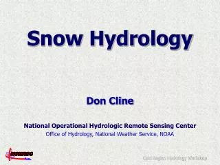
Snow Hydrology Modeling
Snow Hydrology Modeling. Gayle Dana, Ph.D. Division of Hydrologic Sciences Desert Research Institute, Reno NV Gayle.Dana@dri.edu. Talk Outline. Background Approaches Spatial Distribution Assumptions Uncertainties. Snow Hydrology in a Nutshell. Snow Terms. SWE - Snow Water Equivalent

Snow Hydrology Modeling
E N D
Presentation Transcript
Snow Hydrology Modeling Gayle Dana, Ph.D. Division of Hydrologic Sciences Desert Research Institute, Reno NV Gayle.Dana@dri.edu
Talk Outline • Background • Approaches • Spatial Distribution • Assumptions • Uncertainties
Snow Terms • SWE - Snow Water Equivalent • The height of water if a snow cover is completely melted, on a corresponding horizontal surface area • Snow Depth x (Snow Density/Water Density) • SNOTEL • Network of automated sites collecting precipitation and SWE data
Snow models can be found in: • General Circulation Models (GCM) • Regional Climate Models • Weather Prediction Models • Snow Process/Hydrology Models • Watershed Models • Operational Runoff Forecasting • Frozen Soils Studies • Avalanche Forecasting • Erosion Control
Outline • Background • Approaches • Spatial Distribution • Assumptions • Uncertainties
Two Basic Approaches • Empirical • Temperature Index Models • Regression Models • Physically based • Energy Balance Models
Empirical: Temperature Index • Estimates snowmelt, M (cm d-1), as linear function of near-surface air temperature: M = a Td Td , daily average temperature (ºC) A, melt factor (cm d-1 deg ºC -1) (situation specific)
Why does the Temperature Index Method Work? • During melting, the snow surface temperature near 0 C, and energy inputs (radiation, turbulent) are approximately linear functions of air temperature.
Empirical: Regression Y =a + b1BF + b2FP + b3WP + b4S + b5SP Y = predicted runoff volume BF = base flow index FP = fall precipitation index WP = winter precipitation index S = snow water equivalent index SP = spring precipitation index a = streamflow intercept bi = regression coefficients
A t m o s p h e r e K S o l a r S o l a r I n c i d e n t / E m i t t e d L o n g w a v e E N E R G Y L L C a n o p y M A S S S h o r t w a v e C a n o p y R e d u c t i o n W i n d W i n d R e d u c t i o n R e f l e c t e d Q p S n o w C a n o p y S o l a r L o n g w a v e R a i n K E m i s s i o n s T e m p e r a t u r e V a p o r H u m i d i t y Q Q h e T u r b u l e n t A l b e d o E x c h a n g e S n o w Q M E L T I N G M e l t F l o w R E F R E E Z I N G C o n d u c t i o n Q g T h e r m a l l y A c t i v e S o i l L a y e r Physical: Energy Balance (K-K) + (L - L ) + Qe + Qh + Qg + Qp = Q
Modeled Processes From Melloh, 1999
Meteorological Requirements From Melloh, 1999
Talk Outline • Background • Approaches • Spatial Distribution • Assumptions • Uncertainties
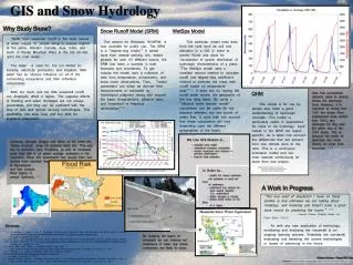
Spatial Distribution of Snow Models • Lumped • Polygon Discretization • Gridded
Incline Creek Watershed, Lake Tahoe Upper-Upper Basin Lower-Upper Basin Lower Basin Mid Basin Exit to Lake Tahoe Upper-Upper Basin Lower-Upper Basin Lower Basin Mid Basin Exit to Lake Tahoe Lumped • Parameters assigned to sub basins
Polygon Discretization Taylor Valley, Antarctica 46 land classes based on slope, aspect, surface type • Parameters assigned to land classes • based on physical characteristics
Gridded (Fully Distributed) Emerald Lake Basin, CA • Parameters assigned to each cell in grid • adapted from Cline et al 1998
Regression Trees • Parameters assigned to grid cells based on physical characteristics • derived from DEM Winstral et al, 2002
Incorporating Remote Sensing from Cline et al, 1998 …..and Depletion Curves
Calibration / Validation Snow depth sampled at 504 sites! Winstral et al, 2002
Calibration / Validation SNOTEL data often used for calibration & validation
Talk Outline • Background • Approaches • Spatial Distribution • Assumptions • Uncertainties
Assumptions • Assumed values for snow properties difficult to measure • Spatial interpolation of point data (e.g., meteorological) is valid for entire modeled area • Heat conduction from soil negligible (some models) • Uniform density and compaction (simple models)
Talk Outline • Background • Approaches • Spatial Distribution • Assumptions • Uncertainties
Uncertainties Leading to Model Error • Data availability • Data consistency • Data quality, especially wind effects on: • Snow precipitation • Redistribution of snow on the ground • Extrapolating point data • Poor understanding of physical processes
Web Resources • SNOW MODELERS INTERNET PLATFORM www.geo.utexas.edu/climate/Research/SNOWMIP/ • Snow Models Intercomparison Project (SnowMIP) www.geo.utexas.edu/climate/Research/SNOWMIP/ • National Snow and Ice Data Center (NSIDC) nsidc.org/ • Snow Data Assimilation System (SNODAS) nsidc.org/data/g02158.html • SNOTEL (Natural Resources Conservation Service) http://www.wcc.nrcs.usda.gov/snotel/ SnowMIP results for Sleeper River
References • Cline, D., R. C. Bales, and J. Dozier. 1998. Estimating the spatial distribution of snow in mountain basins using remote sensing and energy balance modeling. Water Resources Research, 34(5):1275–1285. • Luce, C.H. and D. G. Tarboton. 2004. The application of depletion curves for parameterization of subgrid variability of snow. Hydrol. Process.18, 1409–1422. • Martinec, J., and A. Rango. 1981. Areal distribution of snow water equivalent evaluated by snow cover monitoring, Water Resour.Res., 17(5), 1480–1488. • Melloh, R. 1999. A synopsis and comparison of selected snowmelt algorithms. CRREL Report 99-8-17. Online: www.crrel.usace.army.mil/techpub/CRREL_Reports/reports/CR99_08.pdf • Seidel, K. and J. Martinec, 2004. Remote Sensing in Snow Hydrology-Runoff Modeling, Effect of Climate Change. Springer. • Singh, P. and V. P. Singh, 2001. Snow and Glacier Hydrology, Kluwer Academic Publishers, 742p • U.S. Army Corps of Engineers. Runoff from Snowmelt. 1998. Engineer Manual 1110-2-1406. Online: www.usace.army.mil/inet/usace-docs/eng-manuals/em1110-2-1406/entire.pdf • Winstral, A., K. Elder, and R. E. Davis, 2002. Spatial snow modeling of wind-redistributed snow using terrain-based parameters. J. Hydrometeorology (3):524-538.