Improving Snow Modeling
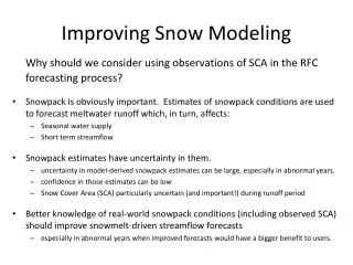
Improving Snow Modeling. Why should we consider using observations of SCA in the RFC forecasting process? Snowpack is obviously important. Estimates of snowpack conditions are used to forecast meltwater runoff which, in turn, affects: Seasonal water supply Short term streamflow

Improving Snow Modeling
E N D
Presentation Transcript
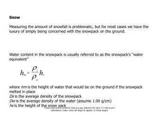
Improving Snow Modeling Why should we consider using observations of SCA in the RFC forecasting process? • Snowpack is obviously important. Estimates of snowpack conditions are used to forecast meltwater runoff which, in turn, affects: • Seasonal water supply • Short term streamflow • Snowpack estimates have uncertainty in them. • uncertainty in model-derived snowpack estimates can be large, especially in abnormal years. • confidence in those estimates can be low • Snow Cover Area (SCA) particularly uncertain (and important!) during runoff period • Better knowledge of real-world snowpack conditions (including observed SCA) should improve snowmelt-driven streamflow forecasts • especially in abnormal years when improved forecasts would have a bigger benefit to users.
Improving Snow Modeling (con’t) • Current sources of snowpack information used at CBRFC: • SNOTEL SWE observations • SNODAS via NOHRSC web site (used subjectively by hydrologists/forecasters to make model modifications) • SNOW-17 model-derived estimates of SWE and SCA (termed AESC in SNOW-17) • No satellite-derived observations of SCA (which are readily available) are used explicitly in the RFC forecasting process at this time. • Satellite-derived SCA obs would provide a beneficial, quantitative source of SCA information in addition to, and independent of, the datasets already in use at the RFC. • CBRFC currently engaged with: • CWCB Rti project • OHD data assimilation project
CWCB SCA Project • Purpose of project: use SCA to improve snow modeling and water forecasts • Groups involved: • CWCB, RTi, NRCS, RFCs (CB, WG, MB, AB) • RTi is processing two types of SCA data: • MODIS SCA from NASA (higher priority for CBRFC) • SCA derived from NOHRSC/SNODAS.
FSCA Grids - daily mosaic over CO, most of Colorado Basin - some bad values rm’d Binary SCA Grids: if the SNODAS SWE pixel is > 0.10”, then it assumed to be snow-covered. NASA MODIS SCA tiles - MOD10A1 (Terra only) - 500 m resolution FSCA averages by basin and elevation zones - with quality info CWCB SCA Project - Overview of Datasets MODIS Datasets: 2000 to 2011 SNODAS Datasets: 2003 to 2011 NOHRSC SNODAS SWE Product SCA averages by basin and elevation zones
CWCB SCA Project – MODIS FSCA Grids June 22, 2011 MODIS FSCA Grid from RTi MODIS Visible image from USFS (http://activefiremaps.fs.fed.us/imagery.php?op=fire&passID=136716) May 5, 2011 MODIS FSCA Grid from RTi MODIS Visible image from USFS (http://activefiremaps.fs.fed.us/imagery.php?op=fire&passID=130779)
Little Cottonwood Creek 2010 Melt dashed = model AESC solid lines = 14 d moving avg from the MODIS-derived SCA points
CWCB SCA Project – MODIS Basin FSCA Time Series RTi-produced MODIS FSCA Grids + CBRFC basin and elevation zone shapefiles = daily estimates of FSCA for basins and elevation zones • Pixels with problems are ignored in the calculations • The remaining pixels within the basin polygon are used to estimate the basin FSCA Quality values for the FSCA estimates: • 0 = most confidence in the FSCA values. • 100 = worst confidence in the FSCA values
CWCB SCA Project – MODIS Basin FSCA Time Series • Same plot for WY10 (LCC Case) • + FSCA grids zoomed in on that basin RTi dataset ends on June 30, 2011
OHD SWE Data Assimilation Project • OHD contacts: Kevin He, Haksu Lee • Purpose of the project is to answer: • Would assimilation of SNOTEL SWE obs into SNOW-17 via an Ensemble Kalman Filter (EnKF) help retrospective streamflow simulations in certain CBRFC basins? • Or, would updating the SWE states with observed SWE information degrade the simulations? • If the results are a mixed bag: • id where and why the assimilation helped • where and why it caused the simulations to be worse than the control • Still in early stages
Study basins (as of 8/2/11): • WBRW4 • HMFW4 • WTRU1 • FISC2 • SKEC2 • ALEC2 • DRGC2
OHD SWE Data Assimilation Project (cont.) • Study methodology is similar to a previous study of the North Fork of the American River in the Sierras by He, et al. • Create mean areal SWE values (for assimilation) via PCR using obs and model information. • Perturb MAT/MAP forcings to create ensembles. • Precip: log-normal distribution, Temp: normal distribution • Assimilate the computed mean areal SWEs and update SNOW-17 SWE states via an EnKF • Uses uncertainty information in the observed SWE and the model SWE to weight one over the other. • Check how the assimilation affects the streamflow simulations.
Painter Proposal • Proposed work to NASA (currently under review) • Goal: Introduce MODSCAG dataset into CBRFC modeling system • Method: Highly interactive between research group and CBRFC with personnel exchanges, data exchanges, etc.