Download
1 / 5
50 likes | 149 Vues
Learn how to display geospatial data using Google Maps and other open-source GIS software. Discover the "Godiva2" website for quick visualizations of numerical models and satellite data, with interactive features to select and view datasets on a draggable, zoomable map. Easily visualize data at various scales and in Google Earth's 3-D globe. This lightweight GIS tool generates images dynamically on the server, eliminating the need to download data. Explore using WMS and open standards for efficient image generation and visualization across different platforms. Join the future of visualizing environmental data effortlessly!

E N D
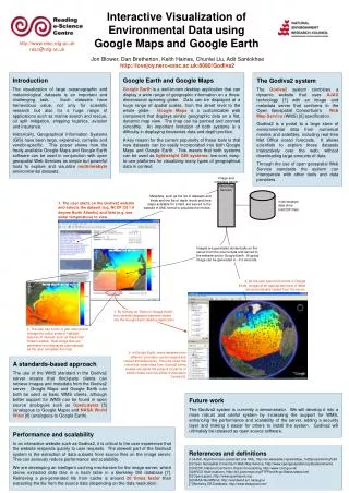
Using Google Maps and other OpenSource GIS software for displaying geospatial data Jon Blower, Dan Bretherton, Keith Haines, Chunlei Liu, Adit Santokhee Reading e-Science Centre Environmental Systems Science Centre University of Reading
Exploring environmental data with Google Maps and Google Earth • “Godiva2” website provides very quick visualisations of numerical model and satellite data • Scientists use an interactive website to select dataset to visualise on a draggable, zoomable map • can view data at large range of scales • Can then view same data in Google Earth • 3-D globe • Lightweight, easy to use GIS tool • Can visualise alongside other datasets • Don’t have to download any data! • Images generated dynamically on the server • Spin-off from GODIVA project
Architecture WMS WMS Could use images from many other WMSs DATA DATA metadata (XML) images (PNG) WMS = OGC-compliant Web Map Service Web server HTML, Javascript Web server and WMS could be co-located
Open standards and open source • Godiva2 website gets its images from a standards-compliant Web Map Server • (or at least it will do soon…) • We built a WMS for dynamically generating images from NetCDF data • takes ~0.3 seconds to generate an image • are working on an intelligent cache for greater efficiency • Means that third-party GIS software can get images from our WMS • And we can display images from other WMSs • Are considering switching from Google Maps to OpenLayers • Open Source equivalent, no licensing or API issues • Better support for WMS
The intention / the future • Project generates CF-compliant NetCDF • Run a Web Map Server out of the box • i.e. the Godiva2 server • Visualise the data instantly on Godiva2 website and Google Earth • Alongside other datasets from third parties e.g. satellite images • Need to handle vectors for currents!!! • Would be nice to visualise derived fields • Temporal and spatial averages • Can we generate the images fast enough on the server? • Also visualise on other WMS-compliant tools • NASA WorldWind • Cadcorp SIS