Climate Information for Society
370 likes | 543 Vues
Climate Information for Society. Roberto J. Mera Climate Modeling Laboratory Marine, Earth and Atmospheric Sciences North Carolina State University National Climatic Data Center February 19th, 2010. Global Warming?.

Climate Information for Society
E N D
Presentation Transcript
Climate Information for Society Roberto J. Mera Climate Modeling Laboratory Marine, Earth and Atmospheric Sciences North Carolina State University National Climatic Data Center February 19th, 2010
Global Warming? • Recent events showcase the uncertainties inherent in the study of world climate • It also offers us an opportunity to examine how climate change (natural or anthropogenic) relates to the general public
Ongoing Research • The questions facing decision makers are all multivariate in nature and shrouded in many vexing uncertainties • Our work at the North Carolina State University (NCSU) Climate Modeling Laboratory (CML) explores the interface between climate information and end user applications
How will climate change affect healthcare? How will it affect food supply and energy demand? The Future of Climate Science: Climate Applications
Education • In 2008, UNC-Asheville’s Strategic Plan stated that the business community, government agencies and public policy-makers have identified climate change as an economic development priority for the region • In 2009, plans for a Master’s degree in Climate Information for Society acquired support from the Marine, Earth and Atmospheric Sciences Department at NC State University • This degree also benefits from collaboration with the International Research Institute for Climate and Society • Plans for the degree are moving forward and classes could begin as early as fall 2011
Internships & Opportunities • A list of parties interested in a Climate and Society Master’s student: • NCDC, Oakridge National Laboratories, Forest Service, NC State Climate Office, Unison Engine Components, Volvo North America, Mission Hospitals, Henderson Co., Durham Co., Orange Co., Town of Chapel Hill, City of Asheville, Biltmore Estate, Nature Conservancy, Progress Energy, Land of Sky, NC State Energy Office, SRC, AquaTerra, WildSouth
Prospective students • Undergraduate students • Mid-career students • Backgrounds vary from • economics to environmental • sciences, visual arts, non-profit, engineering, • meteorologists, planners, government, • business administration, ecology
International Perspective • Interest on graduate and undergraduate climate change programs has gained momentum in West Africa and South America • Collaboration with theSysTem for Analysis, Research and Training (START) program
NOAA ISET @ NCSU • Involves collaboration of PI's from Marine Earth and Atmospheric Sciences, Mathematics, Physics at NCSU, NCA&T, and CUNY and divided into two sub groups: • Analysis of Observing Systems: Severe Storms & Hurricanes Research • Analysis of Observing Systems: Physical and numerical research approach
NOAA ISET @ NCSU • Recent Research: • --African Easterly Wave interaction with Isentropic Descent off the coast of West Africa • --GIS modeling of coastal flooding due to hurricanes in North Carolina • --Variability of springtime westward-propagating disturbances in West Africa
Relevance to Society • The general population is more concerned with their own applications (health, agriculture, insurance) • Climate data products are often too complex or irrelevant for the public sector • New technology and techniques are required to relay climate information
Problems with data • The development of relevant products for society is reliant on the data available • Much of the data is limited in scope, accessibility and format • In-situ data, for example, is sometimes scattered and incomplete, making it less useable for agricultural management
Data Access • The US has an advantage over other countries that struggle with data acquisition and formats • We work with various institutions to streamline conversion of climate data for specific applications • New developments in the US are aimed at streamlining data access and visualization for specific applications
Dissemination • Collaborators: • World Climate Research Programme, World Bank • UCAR/USGS – Rocky Mountains Climate Response Center, cooperation between end-users and climate modelers (DeWayne Cecil, Jeffrey Kershner) • Oregon Climate Change Research Institute (OCCRI) – GIS- based visualization products of extreme events / topography • Google.org / UCAR Africa Initiative (meningitis outbreaks) – using IDV, GIS, GraDs, NCL and other graphics interface software
Meningitis Outbreaks in West Africa: A Climate Application Study Google/UCAR Africa Initiative Project
Meningitis in Africa • Meningitis is a serious infectious disease affecting 21 countries • 300 million people at risk • 700,000 cases in the past 10 years • 10-50 % case fatality rates
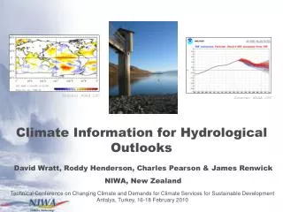
Meningitis-Climate link • Outbreaks coincide with dry, dusty conditions over the Sahel due to the Harmattan winds • Largest correlation occurs between humidity and disease outbreaks (Molesworth et al., 2003) • Disease occurrence drops dramatically with the onset of humidity SHL SHL Harmattan Moisture January July
Largest correlation occurs between humidity and disease outbreaks (Molesworth et al., 2003) Disease occurrence drops dramatically with the onset of humidity Previous studies have been aimed at specific locations and for the start of meningitis 1998 2004 Pink: # of cases Orange: Relative Humidity (%)
Current Efforts • UCAR, in conjunction with IRI, NCSU, Navrongo (Ghana) Health Research Center are working on a prototype Earth-gauging system integrating weather and health data to manage meningitis • The latest research was presented at the World Health Organization (WHO) Meningitis Environmental Risk Information Technologies (MERIT) project meeting in Niamey, Niger in 2009
Google/UCAR Project at NCSU • Recent work for the MERIT project has been aimed at constructing a decision tree on “action threshold” for vaccine implementation • This decision tree, however, does not include climate information at this point • Our aim is to address the climate factors pertinent to meningitis mitigation
Our Study: Predictability of Atmospheric Moisture • What are the variables important for the prediction of the moisture regime? • What are the sources of moisture in West Africa during the Boreal Spring? • Can regional climate models forecast moisture transport dynamics?
The Variables • Variables related to the West Africa monsoon have the highest correlation with meningitis • We use relative humidity (RH) as an indicator in our study From Yaka et al (2008)
Sources of Moisture • We employ a parcel back-trajectory analysis utilizing u and v wind components from the NCEP/NCAR reanalysis for 2000-2008 • The end points surface is set at 925mb *NCEP: National Centers for Environmental Prediction *NCAR: National Center for Atmospheric Research
Source Regions P1 P2 P3
Dynamical Downscaling • Analysis of added value of dynamical downscaling • We use the Weather Research and Forecasting WRF Model as both a predictive and analytical tool for • High resolution reanalysis • Real-time forecasts • Sensitivity experiments • Comparison with large-scale models Scale of relevance
Advantages of Dynamical Downscaling Ghana Ghana WRF at 30km resolution NCEP/NCAR Reanalysis at 2.5°
Relaying Information • We use prototype GIS technology to deliver climate-related information for meningitis mitigation in West Africa • We can overlay climatic conditions of different types (remote sensing, in-situ, model) over meningitis attack rate reports
Future Work • Data assimilation of satellite and in-situ information for further analysis of the meningitis-climate interface • Integration of WRF into meningitis prediction • Simulations using spectral nudging to retain large scale information from the air mass source regions • Stratification of predictive model skill for different modes of variability
Communication • Updates on our work: http://climlab.meas.ncsu.edu/googleucar • twitter.com/climlab