Download
1 / 14
140 likes | 162 Vues
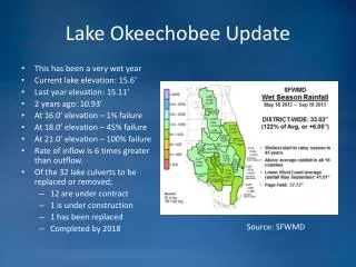
This study examines the influence of Lake Okeechobee sea surface temperatures (SST) on numerical predictions of summertime convective systems over South Florida. High-resolution SST simulations and experiments with the Weather Research and Forecasting model (WRF) were conducted using MODIS SST and RTG SST data. The results highlight the significant impact of varying Lake Okeechobee SST on convective system simulations and surface fluxes over the lake.

E N D
IMPACT OF LAKE OKEECHOBEE SEA SURFACE TEMPERATURES ON NUMERICAL PREDICTIONS OF SUMMERTIME CONVECTIVE SYSTEMS OVER SOUTH FLORIDA Michael E. Splitt1, Jonathan L. Case2, Kevin K. Fuell3, Pablo Santos4, Steven M. Lazarus1, and Gary J. Jedlovec5 1Florida Institute of Technology, Melbourne, FL 2ENSCO, Inc./Short-term Prediction Research and Transition (SPoRT) Center, Huntsville, AL 3University of Alabama – Huntsville/SPoRT Center, Huntsville, AL 4NOAA/NWS Miami, Miami, FL 6NASA/SPoRT Center, Huntsville, AL
HighResolution SST Simulations • NWS MFL Experiments with WRF-NMM [ EMS ] • MODIS SST Composite ( 2 km)vs. RTG SST (~9 km, Daily) • MODIS SST: Regional near real time product (Haines et al. 2007) • MODIS Products available at 0400, 0700, 1600, & 1900 UTC • Both MODIS SST and Control model runs [RTG SST] use static SST • SPoRT model set up nearly replicates real-time NWS MFL implementation • Twenty-seven hour forecasts are run daily with start times of 0300, 0900, 1500, and 2100 UTC on a domain with 4-km grid spacing • Lake Okeechobee Experiments with WRF-ARW • MODIS Composite: time varying [ SSTVAR ] vs. static [ Control ] • In-situ observations (SFWMD1) used to modify MODIS product • WRF SST updated along with boundary forcing (3 hourly) 1 South Florida Water Management District
Model Domains for Case Studies • NWS MFL case study conducted for a Mesoscale Convective System (MCS) that produced hail ~ 1 inch, high winds and an F0 tornado. 0300/0900 initialization times only. • Lake Okeechobee case study conducted for a fair weather easterly flow event. Lake Okeechobee Experiments NWS MFL Experiments
6 May 2007 South Florida MCS HPC surface analysis for 6 May 2007 1800 UTC and WRF model domains for the NWS MFL (black box) and Lake Okeechobee (red box) experiments.
Initial Condition Differences: SST 06 May 2007 0300 UTC 06 May 2007 0900 UTC [MODIS SST – Control] SST [0.1°C] [MODIS SST – Control] SST [0.1°C] • Control simulations use RTG SST • MODIS SST simulations use latest MODIS Composite • The most significant differences between the 0300 & 0900 SST is in the vicinity of Lake Okeechobee. (using 19z and 04z MODIS, respectively) • MODIS product warmer/cooler than RTG at 0300/0900 UTC over Lake Okeechobee
MCS Simulation: Impact MODIS SST: 0300 UTC Run Control:0300 UTC Run • Maximum 10-m wind ranged from 13.6 to 14.9 m s-1, with the highest recorded in the 0900 UTC MODIS SST run. • Maximum cloud top heights ranged from 12657 – 13813 m, with the highest recorded in the 0300 UTC MODIS SST run. • Maximum composite reflectivity ranged between 43 and 45 dBZ, with the maximum value achieved in both MODIS SST runs.
MCS simulation: Early evolution MODIS SST – Control : 0300 UTC Run valid at 0700 UTC MODIS SST - Control: 0900 UTC Run valid at 1300 UTC • Model difference (MODIS SST - Control) in 10-m wind speed (m s-1, shaded), divergence (*10-5 s-1, contoured), and wind speed vector differences (reference vector 10 ms-1) 4 hours into the 0300 UTC and 0900 UTC NWS MFL MCS simulations. • The most significant differences in the early portion of the simulations were associated with SST specification in SST of Lake Okeechobee.
Varying Lake SST: Anchor and Drift Step 1: Start with MODIS SST Composite. 0700 UTC MODIS Composite 2200 UTC MODIFIED SST Step 2: Anchor Composite SST over Lake Okeechobee to the observed Lake Temperature at Composite Valid Time. Step 3: Drift Composite SST in time over the Lake along with observed changes. Step 4: Repeat process as new MODIS Composite becomes available. Hourly GRIB2 modified MODIS Composites are generated for ingest into WRF. SWFMD LZ40 Lake Surface Temperature
Simulation: 01 May 2007 0900 UTC Easterly Low Level Flow SSTVAR vs. Control • WRF ARW initialized with Static (Control) and varying (SSTVAR) lake temperatures • SST differences on the order of 4 °C • Limited convection with easterly flow Lake Temperature (°C) SSTVAR Control Forecast Hour
Model Impact: SSTVAR vs. Control Sensible Heat Flux (Wm-2) SSTVAR Latent Heat Flux (Wm-2) SSTVAR • Simulated surface fluxes over the center of Lake Okeechobee significantly impacted by use of diurnally varying Lake Temperature. Control Control Forecast Hour Forecast Hour
Model Impact: SSTVAR vs. Control 2-m Air Temperature 10-m Wind Speed • Model differences (SSTVAR – Control) 12 hours into the simulation for 2-m temperature (°C) and 10-m wind (ms-1). • Stronger easterlies in the SSTVAR simulations are attributed to enhanced mixing [due the larger surface fluxes/air temperature] throughout the forecast period. • SWFMD Stations L005 and LZ40 are just outside the zone of maximum wind impact. L005 L005 LZ40 LZ40
SSTVAR: 10 m wind validation • LZ40 simulated SSTVAR wind speed is higher (f06-f12 h) compared to observations. LZ40 wind speed is initialized too high in both runs. Observations shows delayed increase in wind speed relative to the simulations. • L005 simulated SSTVAR wind speed trend matches well between 9 and 14 hours. L005 wind speed is initialized too low in both runs.
SSTVAR: 2 m Temperature validation • Air temperature initialized too warm at L005. • Air temperature trends appear to be better captured by the SSTVAR simulations at both locations, especially at L005.
Concluding Remarks • SUMMARY: Static SST and time varying SST WRF simulations were conducted using the MODIS SST COMPSITE Product • Simulations of an MCS produced differences that may have stemmed from the specification of SST over Lake Okeechobee • Simulations testing the use of diurnally varying SST over Lake Okeechobee revealed significant impact over Lake Okeechobee • Model validation indicates potential issues with the surface/mixed layer and/or initialization. • Acknowledgments • Research was funded by Dr. Tsengdar Lee of the NASA Science Mission Directorate’s Earth Science Division in support of the SPoRT program at the NASA Marshall Space Flight Center • Thanks to the South Florida Water Management District (SWFMD) for data support; and to Dr. Kang-Ren Jin for additional data interpretation