Download
1 / 11
110 likes | 277 Vues
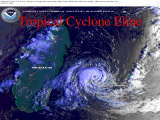
Development of a Tropical Cyclone Rain Forecasting Tool Frank D. Marks NOAA/AOML, Hurricane Research Division, Miami, FL 33149. QPE Techniques in TCs TRMM and gauges QPF Techniques in TCs R-CLIPER 2002 Storms Where do we go from here?. Support from NOAA JHT and NASA TRMM and CAMEX.

E N D
Development of a Tropical Cyclone Rain Forecasting ToolFrank D. MarksNOAA/AOML, Hurricane Research Division, Miami, FL 33149 • QPE Techniques in TCs • TRMM and gauges • QPF Techniques in TCs • R-CLIPER • 2002 Storms • Where do we go from here? Support from NOAA JHT and NASA TRMM and CAMEX
QPE techniques in TCs: DATA: • TMI R estimates for 245 storms (December 1997-2000), globally, yielding 2121 events, from TD to CAT5 (Lonfat et al 2003). 1998-2000 TMI events by Intensity Storm Intensity Events % TD/TS 1361 64 Category 1-2 548 26 Category 3-5 212 10 Total 2121 • 560,000 hourly gauge estimates in 46 US landfalling hurricanes (1948-2000) (DeMaria 2003)
QPF techniques in TCs: • Develop R-CLIPER from gauge and TMI climatology for operational and model QPF comparisons. • Project R-climatology along NHC forecast track.
R-CLIPER • Radial distribution of R for gauge and TMI climatology consistent. • TMI peak R increases with intensity: 3 mm h-1 TD/TS; 7.2 mm h-1 CAT 1-2; 12.5 mm h-1 CAT 3-5. • TMI peak R radius decreases with storm intensity.
R-CLIPER Cases 7.7” 15.9” 4.8” color contours denote Rtotal (inches, peak at landfall listed) Position and intensity from best track (6 h) 8.6” 4.1”
R-CLIPER Cases Danny 97 • R-CLIPER underestimates area of Rtotal by factor of 2 using CDF. % of gauges PMM R-CLIPER/Gauge Rtotal 90% 90% Andrew 92 Allison 01 50% 50% % of area 20% Floyd 99
QPF in Landfalling TCs • For 2002 season ran 584 forecasts in 32 storms in the ATL, EPAC, and CPAC for both the gauge and TRMM R-CLIPER.
QPF in Landfalling TCs Gauge TRMM
Where do we go from here? • R-CLIPER ran operationally in 2002 at NHC. • Provides benchmark for evaluation of other QPF techniques. • Develop data products for hurricane specialists. • Compare R-CLIPER forecasts to models and 6-h average rainfall amounts on HPC 1°X1° grid. • Work with HPC to provide track guidance after landfall.
Comparison with Models Rogers et al 2002 • RCLIPER Rmax along track, with a probability of heavy rain right or left of track. • RCLIPER Rmax increases when storm slows or turns. • Model shows symmetry and asymmetry. RCLIPER
QPF in Landfalling TCs ISSUES: • Are we providing our users what they need? Different users have different needs. • How do we develop an evaluation/validation system for high-resolution QPF product? • How will it be used operationally (probabilistic)? NEEDS: • New products developed for forecasters and hydrologists. • New display products to convey uncertainty to forecaster and others.