Download
1 / 18
180 likes | 456 Vues
Chapter 4: Physical Geography of the United States and Canada Highest Point: Mount McKinley – Alaska Lowest Point: Death Valley – California Largest Lake: Lake Superior – U.S./Canada Longest River: Mississippi-Missouri – U.S.

E N D
Chapter 4: Physical Geography of the United States and CanadaHighest Point: Mount McKinley – AlaskaLowest Point: Death Valley – CaliforniaLargest Lake: Lake Superior – U.S./Canada Longest River: Mississippi-Missouri – U.S.
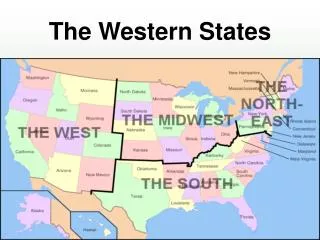
48 “contiguous” states: the states that are joined together inside a common boundary Major Landforms of U.S. and Canada: 1. Eastern Lowlands and Highlands: 1. broad lowland runs along the Atlantic and Gulf of Mexico 2. fertile, hilly area called the Piedmont stretches inland along the coastal plain
3. Cities stretching along the Atlantic Coast form a “megalopolis” – a connected area of urban communities 4. West and north of the Atlantic Coastal plain spread a number of highland areas including the Appalachian Mountains
2.Interior Lowlands:1. West of the eastern highlands are vast interior lowlands – these include The Canadian Shield - a horseshoe-shaped area of rocky hills, lakes, and evergreen forests that wrap around the Hudson Bay
2. South of the Canadian Shield and west of Appalachians lies the Central Lowlands – grassy, rolling lands with thick forests and fertile farmland. Many important waterways are located here as well.3. The Great Plains stretch west of the Mississippi River –prairie – rolling inland grasslands with fertile soil.
3. Western Mountains and Plateaus:1. West of the Great Plains is a “cordillera” – group of mountain ranges that run side by side. – Rocky Mountains, Sierra Nevada, Cascade Ranges, Coast Ranges, and Alaska Ranges.
2. Between the Pacific Ranges and the Rocky Mountains are stretches of dry basins and high plateaus. 3. Southern part of this area rivers have worn “canyons” - deep valleys with deep sides. – The most famous being The Grand Canyon.
Bodies of Water: - The Great Lakes – world’s largest group of freshwater lakes – There are 5. Located on the border of U.S. and Canada. These were formed by “glaciers” – giant sheets of ice. – Superior, Michigan, Huron, Ontario, and Erie – flow into the St. Lawrence - St. Lawrence River – one of Canada’s most important rivers
- The Mississippi River – North America’s longest river - The Continental Divide – high ridge of Rockies that determines direction that rivers flow
Natural Resources: Energy and Mineral Resources: -U.S. and Canada have major energy resources such as oil and natural gas. – Texas ranks first, then Alaska. The U.S. does use nearly 3 times the amount of oil it produces. - The U.S. and Canada also have significant amounts of coal.
- In Eastern areas, highlands drop to lower Atlantic Plain. Along this fall line, rivers break into waterfalls that provide hydroelectric power. Niagara Falls is a major source of hydroelectric power for Canada and the U.S. - Mineral resources are also plentiful in the U.S. and Canada
Soil, Timber, Fish: - Rich soil in parts of U.S. and Canada is excellent for farming- Timber is another important resource that covers much of the U.S. and Canada- Coastal waters are important for large fishing industries
Climate Regions of U.S. and Canada: The Far North:Tundra and subarctic climates are found in northern parts of Alaska and CanadaThe Pacific Coast:The area from southern Alaska to northern California has marine west coast climate year round.
The West: Inland west has desert climate- eastern side of Rocky Mountains often experience droughts- long periods without rainfall
The Great Plains:-humid climate with cold, snowy winters, and hot, humid summersThe East:-humid climate regions with plenty of precipitation – winters temperatures and weather vary
Tropical Areas:- found in two areas of the U.S. – Florida and Hawaii – hot summers, warm winters
Natural Hazards:Severe Weather-tornadoes – funnel cloud windstorm, hurricanes- wind systems over the ocean that bring violent storms and heavy rains, blizzards- winter storms that last several hours with heavy winds and snow
Earthquakes and Volcanoes:- Most earthquakes take place on Pacific coast- where tectonic plates meet are the sites of volcanoes