Download

1 / 16
160 likes | 275 Vues
SDSP at Anadarko. DPUG Meeting November 14 , 2013. Spatial Data Standards and Process Team Overview. “The Map”. Purpose. The SDSP team’s purpose is to address the following issues related to spatial data: Nobody trusted existing data Inconsistent collection processes Versioning issues

E N D
SDSP at Anadarko DPUG Meeting November14, 2013 Spatial Data Standards and Process Team Overview
Purpose • The SDSP team’s purpose is to address the following issues related to spatial data: • Nobody trusted existing data • Inconsistent collection processes • Versioning issues • Data stored in silos • Duplication of efforts • Solution:
Why SDSP? • Improve level of trust in spatial data • Consistent & efficient collection process through survey request process and standard GDB deliverables • Minimize versioning issues • Eliminate spatial data silos
Vision & Mission SDSP Vision: Influence change in Anadarko’s data culture to enhance our competitive advantage SDSP Mission: The Spatial Data Standards & Process (SDSP) Team ensures that newly acquired data* is timely, accurate and reliable and is accessible company-wide to enable our people to work safely and make intelligent business decisions. (Our Team’s primary focus is newly acquired data*. We support historical data cleanup in cooperation with resources stretching beyond our team.) * SDSP supported data includes: Archeological, Boundaries (surface), Electrical, Habitat, Pad Location, Paleontological, Pipeline/Facilities, Rights of Way, Roads, Structures, Water Features, Well Location and Wildlife
Where Do We Sit Organizationally? • SDSP is a service group within E&P Technology Services • Close partnerships with GIS Support and Pipeline Technology groups • Not formally part of IT
What Does SDSP Do? • Data stewards – one stop shop for spatial data • Provide standards for field-collected spatial data • Provide spatial data that is: • Accurate • Reliable • Complete • Timely • Easily Accessed Company-Wide • Provide a place to store the data that cannot currently be stored internally at APC • New technologies
Impact on Operations As-Built Surveying • Better One Call data = Safer operations • The higher level of detail that an as-built provides allows for better planning/decision making, modeling efforts and more accurate reporting to the regulatory agencies • Timely availability in iMaps Increase Safety in One Call As-Built Pipeline Data Collection with Pictures • Surveyors take pictures of equipment and buried assets to give our customers a complete view of the area they are working • Adding pictures to the data that we are receiving will help those that are new to the field • Operators • Contractors • Visitors • Can potentially be used to identify problems Training Internal Data Collectors • Corporate methodology and guidance for internal data collectors – maximize their efficiency • Line Locate Training
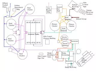
Wattenberg - As-Built vs. Proposed Prior to SDSP Wattenberg was using proposed lines in iMaps and One Call. Illustration below shows the liabilities associated with that practice.
Benefits of SDSP • Spatial data can be leveraged for: • Safety • Better & Quicker Decision Making • Planning & Scheduling • Cost Estimates & Forecasting • Emergency Response • Modeling • Enhance intercompany collaboration
Where We’re Going • Web-based delivery portal for surveyed data • Automated validation tools and processes • Corporate staging database for field-collected data • 2014 deployment of tools, survey standards with internal and external training • Enhanced KPI reporting • LiDAR standards
Next • Jeff Davis, Wattenberg Spatial Data Analyst • Presenting a look at solution for enabling collaborative planning workflows in Wattenberg • Time for questions following Jeff’s presentation