Index Map for Geophysical Studies
90 likes | 241 Vues
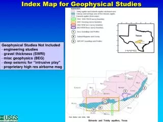
Index Map for Geophysical Studies. Geophysical Studies Not Included engineering studies gravel thickness (SWRI) misc geophysics (BEG) deep seismic for “intrusive play” proprietary high res airborne mag. Enlargement of Sinkhole area. Arrows show EW intersection of sinkhole.

Index Map for Geophysical Studies
E N D
Presentation Transcript
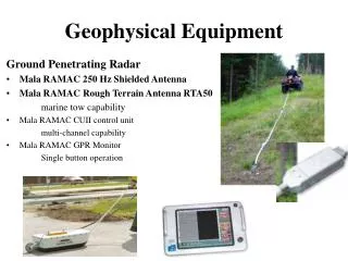
Index Map for Geophysical Studies • Geophysical Studies Not Included • engineering studies • gravel thickness (SWRI) • misc geophysics (BEG) • deep seismic for “intrusive play” • proprietary high res airborne mag
Enlargement of Sinkhole area Arrows show EW intersection of sinkhole Valdina sinkhole entrance Depth meters Sensor height South North
3D Resistivity Model in Progress Recharge area Trinity Capture area Sinkhole Woodard Cave Fault Seco Creek
Seco Creek HEM (view NW to SE)Elevation top Del Rio ASL (meters)
Resistivity 115,000hz Trinity Aquifer units Edwards Aquifer units
High Resistivity zones N BexarHEM survey Trinity Aquifer reefal units Cibilo Creek area Edwards Aquifer units