Download
1 / 9
90 likes | 228 Vues
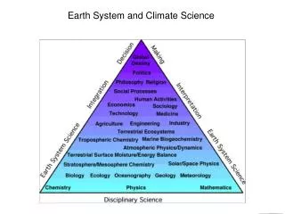
Earth System and Climate Science. Earth System and Climate Science. Computing. Data. ENES – Climate: Scope. ENES is intended to help in the development and evaluation of state-of-the-art climate and Earth system models,

E N D
Earth System and Climate Science Computing
Data ENES – Climate: Scope • ENES is intended to • help in the development and evaluation of state-of-the-art climate and Earth system models, • facilitate focused model inter-comparisons in order to assess and improve these models, • encourage exchanges of software and model results, and • help in the development of high performance computing facilities dedicated to long high-resolution multi-model ensemble integrations.
ENES – Climate: Organisation • ~ 50 member institutions from • 15 European countries • National and EC funds • Some funding statements until 2013 • Long-term institutional commitment from some members available • Large infrastructure FP7 project for ENES has started: IS-ENES
ENES – Climate: Data • Needs for pan-European Data Services • Services to store, retrieve and compare research data • A service layer for transition of research data into community data including long-term archiving and open access • A trusted domain for long-term data preservation and federated data access • Interdisciplinary data utilization is requested for mitigation of and adaptation to climate change
Interoperability drawbacks in Earth system model data usage • Interdisciplinary research presently has problems in model data utilization across disciplines • Federation of geographically distributed data archives is requested Related areas of problems: • Metadata: • Problem: Discipline specific and development specific metadata models and list of values • Improvement: agreed metadata model and controlled vocabularies (METAFOR / CIM as federated data model) • Improvement: Mapping from legacy data model archives to CIM is in the responsibility of the individual archives • Improvement: Mapping to interdisciplinary vocabularies on the basis of personal communication, systematic solution like thesauri are discussed
Interoperability drawbacks in Earth system model data usage • Data storage and formats • Problem: Non modeling communities are not used to data storage (coordinate systems) and model data formats • Improvement: Application adapted data products are pre-processed and disseminated (time series of individual variables) • Improvement: Application adapted server side data processing is offered for data reduction and format conversion (national data Grid projects, EU IS-ENES) • Model data interpretation • Problem: Non modeling communities have problems in applying and interpreting climate model data • Improvement: Guidance on using and interpreting climate model data is provided on-line and on basis of personal communication (IPCC Data Distribution Centre, National Weather Services, Climate Service Centre in Hamburg)