Download
1 / 5
50 likes | 154 Vues
Discover stunning satellite images of Ground Zero in NYC, the Grand Canyon, Maldives, Ayers Rock, and a possible Noah's Ark site on Mt. Ararat. Compare and explore these iconic locations.

E N D
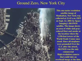
Ground Zero, New York City This one-meter resolution satellite image of Manhattan, New York was collected at 11:43 a.m. EDT on Sept. 12, 2001 by Space Imaging's IKONOS satellite. The image shows an area of white and gray-colored Dust and smoke at the location where the 1,350-foot towers of the World Trade Center once stood. Since all airplanes were grounded Over the U.S. after the attack, IKONOS was the only commercial High-resolution camera that could take an overhead image at the time.
Grand Canyon Northern Arizona and the Grand Canyon are captured in this pair of Multi-angle Imaging Spectroradiometer (MISR) images from December 31, 2000. The above image is a true color view from the nadir Vertical camera. In addition to the Grand Canyon itself, which is visible in the western (lower) half of the images, other landmarks include Lake Powell, on the left, and Humphreys Peak and Sunset Crater National Monument on the right. Meteor Crater appears as a small dark depression with a brighter rim, and is just visible along the upper right-hand edge.
Malosmadulu Atolls, Maldives North and South Malosmadulu Atolls are in the Maldives, an island Republic in the northern Indian Ocean, southwest of India. The Maldives are made up of a chain of 1,192 small coral islands, which are grouped into clusters of atolls. It has a total area of 298 Square kilometers and a population of about 330,000. The capital and largest city is Male, with a population of about 80,000. Arguably the lowest-lying country in the world, the average elevation is just 1 meter above sea level. The natural-color ASTER image of the Malosmadulu Atolls was acquired on December 22, 2002, and is centered near 5.3 degrees North latitude, 73.9 degrees West longitude.
Ayers Rock (Uluru), Australia This IKON OS satellite image of Ayers Rock was collected Jan. 17, 2004. Ayers Rock is located in Kata Tjuta National Park, 280 miles 450km) southwest of Alice Springs, Australia. It is the world's largest monolith, an Aboriginal sacred site and Australia's most famous natural landmark.
Noah's Ark Site? Is it or isn't it? Satellite images of Mt. Ararat, Turkey have pointed to a possible sighting of Noah's Ark. Decide for yourself! Compare this image taken by Digital Globe on September 10, 2003 with Shamrock -- The Trinity Corporation's image (enlarge). Also, note their image is flipped.