Download
1 / 15
160 likes | 312 Vues
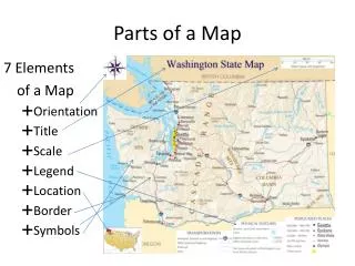
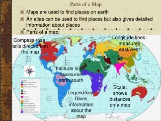
Parts of a Map. Parts of a Map. Most maps have the following elements, which are necessary to read and understand them. Title. The title explains the subject of the map and gives you an idea of what information the map conveys. Compass Rose. The compass rose shows you directions on a map

E N D
Parts of a Map • Most maps have the following elements, which are necessary to read and understand them
Title • The title explains the subject of the map and gives you an idea of what information the map conveys
Compass Rose • The compass rose shows you directions on a map • Cardinal directions are north, south, east, and west • Intermediate directions are northeast, northwest, southwest, and southeast
Labels • Labels are words or phrases that explain features on the map
Legend/Key • A legend or key lists and explains the symbols and use of color on the map
Lines of Latitude • These are imaginary lines that measure distance north or south of the equator and run from east to west on the map. • These lines are also called parallels because they do not touch.
Lines of Latitude • Some important lines of latitude are: • The Equator - 0° • The Tropic of Cancer - 23º 26’ N • The Tropic of Capricorn - 23º 26’ S • The Arctic Circle - 66° 33’ N • The Antarctic Circle - 66° 33’ S
Lines of Longitude • These are imaginary lines that measure distance east or west of the prime meridian and run from north to south on the map. These lines connect at the north and south poles. These lines are also called meridians.
Absolute and Relative Location • Latitude and longitude lines are used to find absolute location. This is an exact point on the earth. • Relative location is NOT an exact location. People use direction and distance to give a general idea of where something is.
Scale • Scale shows the ratio between a unit of length on the map and a unit of distance on the earth
Scale • Ratio Scale - Shows the distance on the map compared to real earth measurement (1 = 30,000,000, 1 = 500 miles) • Bar Scale - Shows the ratio of distance on the map to distance on the earth
Symbols • Symbols represent items such as capital cities, economic activities, or natural resources. Check the map legend for more details