Download
1 / 21
210 likes | 349 Vues
Impacts of Sea Level Rise in the South Florida Region. Presentation to the South Florida Regional Planning Council September 8, 2003. Why Sea Level Rise?. Five warmest average global temperature years on record in 1990s Tenfold increase in rate of sea level rise over 20 th Century

E N D
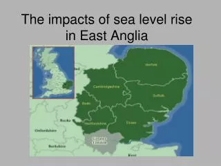
Impacts of Sea Level Rise in the South Florida Region Presentation to the South Florida Regional Planning Council September 8, 2003
Why Sea Level Rise? • Five warmest average global temperature years on record in 1990s • Tenfold increase in rate of sea level rise over 20th Century • Increased rates of beach erosion and acres of coastal wetland losses documented
Why South Florida? • Low elevations and flat topographic profile • Tourism economy dependent on beaches and coastal resources • Significant public and private investments in vulnerable areas
Project Genesis • 1998 - U.S. Environmental Protection Agency (USEPA) initiates and funds study of Sea Level Rise (SLR) impacts on nation’s economy • 2000 – USEPA contracts with Southwest Florida Regional Planning Council (SWFRPC) to coordinate SLR study within Florida • 2002 – SWFRPC contracts with South Florida Regional Planning Council (SFRPC) to map SLR in 7 counties (Indian River, St. Lucie, Martin, Palm Beach, Broward, Miami-Dade, Monroe).
Study Assumptions • SLR timeframe from 2000 to 2200 • Anticipated SLR rate of 5 feet over 200 yrs • New coastline based on existing topography, not erosion or accretion of sediments • Open space/conservation areas allowed to be inundated by SLR • Protection of existing developed areas will be policy decisions for the future
Map Legend • Dark Green – wetlands • Light Green – open space/agriculture • Blue – 0’-5’ – uplands inundated by SLR • Orange – 5’-10’ – uplands influenced by SLR • White - >10’ uplands not affected by SLR
Policy Implications • How to raise level of awareness of decision-makers, especially elected officials • Which areas will we choose to protect • What means will be used to protect • What will be costs of protection • How will these costs be budgeted • How will SLR affect ecological functions
Next Steps • Final report on SLR impacts to be submitted to EPA in late September, 2003 • Plan to raise awareness of study findings in development • Contact us at www.sfrpc.com