Download
1 / 98
1.05k likes | 1.72k Vues
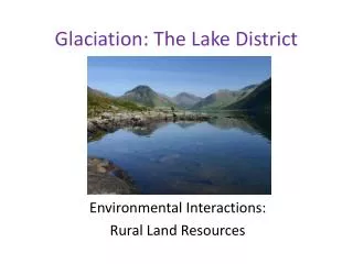
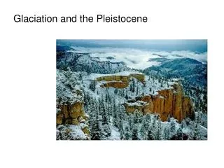
Glaciation and the Pleistocene. Over the last two million years, severe climatic changes had tremendous influence on life on earth. These events were recent enough that a number of techniques that they can be studied using techniques that are not available for more ancient times.

E N D
Over the last two million years, severe climatic changes had tremendous influence on life on earth. These events were recent enough that a number of techniques that they can be studied using techniques that are not available for more ancient times. Pleiostocene pack rat midden in eastern Nevada
Over its history, the earth has undergone many periods of extensive glaciation. Often, this resulted when plate movements positioned large continental blocks over the poles. Much of the Mesozoic and early Cenozoic, however, were characterized by mild climates. Therefore, the glacial and interglacial cycles of the Pleistocene represented a dramatic shift. The Wisconsin maximum
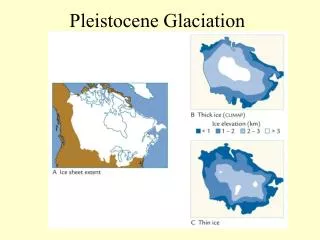
During the Pleistocene, the earth experienced numerous glacial-interglacial cycles. The glaciers were enormous, often 2-3 km thick. At their maximum extent, they covered up to a third of the earths land surface. At the maximum extent of the last glacial period, ice sheets extended to about 45º N. latitude During the last glacial maximum (about 18,000 years B.P.) the Gulf Stream helped keep the North Atlantic relatively warm. It also cooled southern Europe and Africa as it flowed southward.
The last glacial maximum was largely (not entirely) a North American phenomenon.
Glacio-pluvial lakes of western North America During these glacial maxima, prevailing winds shifted. Moist air penetrated into the interior of most continents, causing wet (glacio-pluvial) conditions regions that are now arid. The same climate patterns led now moist tropical regions to be drier during glacial maxima. Glaciation was largely a northern hemisphere phenomenon, simply because of the distribution of land masses.
Move through the next few slides to examine the glacial recession in North America since the Wisconsin glaciation, the last glacial maximum of about 18,000 B.P. (before present). • Watch for: • The retreat of the Laurentide ice sheet, leaving the Great Lakes behind. • The opening of unglaciated areas between the Laurentide and the Cordilleran ice sheets. • The creation of massive Lake Agassiz, which will ultimately burst through the ice dam and empty into the forming Hudson Bay.
The “dumping” of Lake Agassiz is thought by some paleoclimatologists to have triggered the “Younger Dryas”. The present-day Minnesota River Valley was a drainage basin for Lake Agassiz.
What caused the ice ages? Scientists once believed that they had resulted from changes in the output of solar radiation from the sun. This does not appear to be the case. Instead, the Pleistocene ice ages seem to have resulted from changes in the Earth’s orbit which, in turn, resulted in changes in incident solar radiation. These changes are known as Milanovitch cycles.
Milankovitch cycles are periodic changes in: • the eccentricity of the earth’s orbit, i.e., how elliptical the orbit is. This occurs with a period of about 100,000 years. • obliquity, i.e. the tilt of the earth’s axis to the plane of the ecliptic. This occurs with a period of about 41,000 years, over which time the tilt changes from about 22.1 to about 24.5. The current tilt is about 23.5. • The precession of the “point” of the poles. This occurs with a period of about 22,000 years.
It’s also believed that, as ice developed, the increased albedo of the earth led to further cooling.
What’s the Evidence? By analyzing the oxygen contained in the CaCO3 shells of preserved marine invertebrates, we can determine the amount of 16O and 18O present in the atmosphere at the time of the shell formation. The lighter 16O evaporates more rapidly during warmer periods. With calibration, this ratio can be used to esimate temperatures.
Past and (predicted) future changes in the Milankovitch cycles. Periods of the cycles remain relatively constant, but their amplitude varies considerably.
Estimated average global air temperature over the past 850,000 years (inferred from oxygen isotope) measurements from ice cores. Note that we are currently in a very warm interglacial period. In general, interglacials tend to be brief in duration. The earth has undergone at least twenty major glacial periods over the past 2 million years. If you’re wondering how these determinations can be made, here’s a link to a site that describes the use of oxygen ratios in paleoclimatology.
Records of global ocean temperatures over the last 140,000 years indicate that the last two shifts from interglacials to glacial maxima took place of just a few thousand years.
Air temperatures from Eastern Europe over the last 10,000 years….
…and the variation in mid-latitude air temperatures from the Northern Hemisphere over the last thousand years. Again, note that the changes can be rapid. Global temperatures have varied significantly over the last millenium. After the relatively warm Middle Ages, temperatures cooled rapidly and we experienced the “Little Ice Ages”. A recent warming trend began about 150 years ago, and another cooling trend began around 1940.
This cooling trend seems to have been halted and reversed over the last twenty years, apparently by anthropogenically-induced warming.
During the Pleistocene, climates were influenced far south of the glaciers. This figure indicates that many unglaciated regions of North and South America were from 4 to 8C. cooler in the Pleistocene than they are today.
The Laurentide ice sheet which existed from 18,000-9,000 B.P. caused changes in prevailing wind patterns. This had great influence on local climates. While, globally, average ocean temperatures just dropped a couple of degrees, the temperature of the North Atlantic dropped as much as 10C.
As winds moved down the very tall, steep faces of the glaciers, they warmed adiabatically. This moderated conditions in regions adjacent to the glaciers.
The lowering of sea level during the Pleistocene led to the formation of Beringia, which connected North America and Asia. These eustatic changes were global fluctuations in sea level that resulted from the freezing of massive quantities of water.
Lower sea level also resulted in the connection of many of the islands of Indonesia with the mainland of Asia and Australia, respectively. Wallace’s Line, a major biogeographic division, reflects the separation between those glacial land masses.
Two different methods have been used to estimate ancient sea levels, oxygen istope data and the depth of fossil coral reefs. Estimates derived from these two estimates agree reasonably well.
An examination of sea level changes throughout the Pleistocene reveal how rapidly (in a geological sense) the transition from glacial to interglacial conditions can occur.
The coastline of the southeastern U.S. has also changed dramatically since the last glacial maximum.
During the most recent glacial retreat, sea level rose rapidly, creating a shallow sea that covered the Saint Lawrence River Valley, Lake Champlain, and the Ottawa River.
A depiction of animals at the edge of the Champlain Sea. Many marine fossils have been found there, including a number of large marine mammals.
This explains the disjunct distribution of plants such as the seaside spurge, Euphorbia polygonifolia.
Biogeographic Responses to Glaciation A disjunct distribution
Biogeographic changes were triggered by three environmental changes that occurred as a result of the glacial/interglacial cycle. • Changes in the location, extent, and configuration of prime habitats. • Changes in the nature of climatic and environmental zones. • Formation and removal of dispersal routes.
The responses of biotas can also be placed into three categories. • Some species were able to move with their optimal habitat as it changed location. • Some species remained in place and adapted to new conditions. • Some species underwent range reductions, and many ultimately became extinct.
Vegetation zones in Europe during the last glacial maximum (Würm). The zones for most types were shifted to the south by 10 to 20 latitude. In some cases, east-west mountain ranges blocked the southward range shift.
In contrast, the “north-south” mountain ranges and major rivers of North America made it easy for high latitude biomes to shift to the south. The next few slides show the gradual northward retreat of those biomes following the Wisconsin maximum of 18,000 B.P.
Pollen profiles in the Andes Mountains of South America show how vegetation zones have shifted upward since the last glacial maximum. Compare the illustrations below, showing the distribution of vegetation on Andean slopes at the time of the glacial maximum and today. The increasingly warm climate has forced the retreat of the cold-adapted vegetation found higher on the slopes. Note the upward shift of most vegetation zones. Realize how this elevation shift relates to the latitudinal shifts seen earlier.