Download
1 / 21
210 likes | 230 Vues
This presentation outlines the background of the Fifty States Initiative and discusses the major tasks for the "Next Steps" project. It also highlights the importance of the initiative to the National Spatial Data Infrastructure (NSDI) and State GIS Coordination Councils. The presentation includes information on the NSDI framework layers and the FGDC-NSGIC "Nine Criteria" for statewide GIS. It also provides an overview of the Cooperative Assistance Program (CAP) projects in "Category 3" and the major tasks for the "Next Steps" project.

E N D
National Spatial Data Infrastructure (NSDI) Advancing the Fifty States Initiative:Next Steps Update/Review for the FGDC Coordination Group 1/6/09
Presentation Outline • Fifty States Initiative Background • Major Tasks for “Next Steps” Project • Project Support Team • Federal Stakeholder Workshop
Fifty States Initiative Background Importance to NSDI State GIS Coordination Councils Context for “Next Steps” Project CAP “Category 3” Assistance for Strategic & Business Planning
NSDI Framework Layers • Geodetic Control • Cadastral (parcels) • Political Boundaries • Hydrography • Imagery (orthos) • Elevation • Transportation (i.e., Roads, Air, Rail, Transit, Inland waterways…) • … and Structures Multi-Directional Supply & Demand
The FGDC-NSGIC “Nine Criteria” for Statewide GIS • A full-time, paid coordinator position is designated and has the authority to implement the state’s business and strategic plans • A clearly defined authority exists for statewide coordination of geospatial information technologies and data production • The statewide coordination office has a formal relationship with the state’s Chief Information Officer (CIO) • A champion (politician, or executive decision-maker) is aware and involved in the process of geospatial coordination • The responsibilities for developing the National Spatial Data Infrastructure and a State Clearinghouse are assigned • The ability exists to work and coordinate with local governments, academia, and the private sector • The sustainable funding sources exist to meet project needs • GIS Coordinators have the authority to enter into contracts and become capable of receiving and expending funds • The Federal government works through the statewide coordinating authority
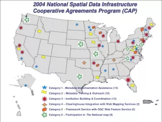
Fifty States Initiative: Cooperative Assistance Program (CAP) projects in “Category 3” • In support of the NSDI and the objectives of the Fifty States Initiative Action Plan, CAP Category 3 projects will: • Develop and implement statewide strategic and business plans for spatial data infrastructure • Facilitate the coordination of programs, policies, technologies, and resources that enable the coordination, collection, documentation, discovery, distribution, exchange and maintenance of geospatial information
35 Recipients of Previous CAP Grants or Partnership Funds
Completed CAP-assisted Business Plans: Thematic Groupings • Data Centric (7) • GIS Coordination Focused (5) • Infrastructure and Enterprise Architecture (3) • Funding Related (3)
Priority 2009 “Category 3” Application Candidates Deadline: 1/6/09….Today!
Major Tasks for “Next Steps” Project Federal Related Components And Key Milestones
Major Tasks: Federal Related Components • Deliver information about Statewide Councils and the Fifty States Initiative to candidates for CAP assistance and assess coordination efforts to-date • Develop strategies with the FGDC and Federal stakeholders on ways to assist statewide coordination • Conduct a facilitated workshop to engage both states and Federal representatives to identify best practices and additional steps to implement completed plans • Outreach to Federal GLOB stakeholders • Workshop being planned for afternoon of 3 February 2009 at NCPC in Washington, DC (confirmed after last Coordination Group meeting)
Project Team Project Sponsors And Contractor Support Team
Project Support Team Project Sponsors: Project Contractor Team:
Federal Stakeholder Workshop Outreach Questions And Workshop Format
Federal Stakeholder Workshop: Outreach Questions • Can Federal agencies benefit from looking at the State GIS Strategic and Business Plans? • For Federal reps working at the state-level, are these reps able to contribute to the planning efforts? • For national program managers, can resource alignment be done better in consideration of the state plans? • For the Federal person on the ground (working within a state), how can they help? • How does the Fifty States Initiative dovetail with other Federal Initiatives?
Federal Stakeholder Workshop: Workshop Format • Half-day Duration • 1:00 PM to 4:00 PM on 3 Feb 08 • Part One: Presentations • Fifty States Initiative Overview • State Mini-case Study (TBD) • Lessons-learned on GIS Strategic & Business Planning • Part Two: Facilitated Discussion • Questions to Federal Stakeholders (and discussion) • Summary of Actionable Items
Input from the Coordination Group Meeting on 12/2/08 • Conduct the Workshop after the February 3, 2009 FGDC Coordination Group meeting, at the NCPC in Washington, DC (in the afternoon) • Send invitation via the FGDC Coordination Group executive secretary, Patricia Phillips • Review draft copy of A-16 Supplemental Guidance for bearing on Workshop agenda (e.g., data themes) • Survey the USGS Liaisons on potential issues for the Workshop (and assess other agencies with people on-the-ground in the states, such as NGS) • Parse a set of finished plans for relevant content and outcomes to present at the Workshop
Input from the Coordination Group Meeting on 12/2/08 • Potential agenda items include: • The Fifty States Initiative: What’s in it for the Federal agencies? • State Case Studies (e.g., on best practices for planning and implementation outcomes) • Parcel Data and/or other geospatial infrastructure data themes (e.g., imagery, transportation, etc.) • Should future assistance for state plans be tied to developing data for NSDI? • Should “data calls” that overlap with NSDI data themes be coordinated across Federal agencies? • Relationship to A-16 Theme Leaders (e.g., who are they, and how would these work at the state-level?) • GeoLOB Smart Buy: What is it, and who can use it?