Basic Map Info -1
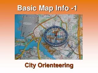
Basic Map Info -1. City Orienteering. City Orienteering takes place in inhabited areas: Among streets, in parks, in the university campus, etc. Category: Sprint (very fast running). Symbols for City Orienteering maps: special symbols to show

Basic Map Info -1
E N D
Presentation Transcript
Basic Map Info -1 City Orienteering
City Orienteering takes place in inhabited areas: Among streets, in parks, in the university campus, etc. Category: Sprint (very fast running)
Symbols for City Orienteering maps: special symbols to show road with traffic, road without traffic, buildings, building pass through...
road with traffic Sprint Map Legends paved area steps paved footpath passable wall impassable wall(forbidden to pass) passable fence impassable fence(forbidden to pass) building(forbidden to pass through) building pass through canopy / covered area man-made object statue closed area (forbidden to pass)
unpaved footpath Sprint Map Legends small unpaved footpath lake / pond(forbidden to pass) distinct tree open land open land with scattered trees rough open land forest - easy run trees in distinct rows vegetation - difficult to run vegetation - very difficult to run vegetation - impossible to run (forbidden to pass) private area(forbidden to pass)
Map 1 Learning the map legends for city-orienteering Map 2
Control Descriptions An Orienteering Course consists of a) the map b) the control points marked on the map and... c) a list of control descriptions showing the exact location of the control point.
(A) This is my 2nd control point. (B) Its number is 225. (D) The control point is in a clearing. There are many clearings near eachother. The control is at the southeastern (C) clearing. The clearing is covered with undergrowth (E) and covers an area of 8x4m (F). The control point is at the western corner (G) of the clearing. This is drinkable water available at this control point. (H)
Common Control Descriptions for City Orienteering (D) appearance on map clue appearance on map clue Road Lake, large pond Footpath Small pond Building Well, drinking fountain Ruin Water tank, reservoire Building pass through Bridge Steps Power line or Paved area Power line pole Statue, monument Tunnel Man-made object Bush or Stone wall Hedge or Fence Distinct tree Earth bank Tree stump - fallen tree
Position of the Control (G) intersection where / which part what junction bend
Orienteering Control Descriptions in many languages http://www.fortnet.org/icd