Enhancing Disaster Prevention Through Boring Data Management Systems
Explore how drilling data can revolutionize disaster prevention through the creation of advanced hazard maps, supported by a national data standard and coordination strategy. Learn about the collaboration involving Nippon Koei Co., Ltd., various public bodies, and the application of boring data in disaster prediction and simulation tools. Discover the potential of utilizing boring data in open systems to improve hazard maps and evacuation planning. Gain insights into the metadata handling and development of data standards in the field of boring data.

Enhancing Disaster Prevention Through Boring Data Management Systems
E N D
Presentation Transcript
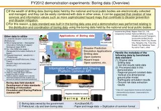
FY2012 demonstration experiments: Boring data (Overview) ○If the wealth of drilling data (boring data) held by the national and local public bodies are electronically collected and managed, and they can be easily combined with data in other areas, it can be expected that creation of new services and information values such as more sophisticated hazard maps that contribute to disaster prevention and disaster mitigation. ○For this reason, a data standard was built in the boring data area and a demonstration was performed relating to the distribution and coordination of boring data using the boring data held by the national and local public bodies. Implementing Body: Nippon Koei Co., Ltd. Cooperation bodies: National (Ministry of Land, Infrastructure and Transport), local public bodies(Kochi Prefecture, Kochi City, Konan City, Nangoku City, Tosa City, Susaki City, Nakatosa Town, Kuroshio Town), other Applications of Boring data Other data to utilize ○ Landslide disaster caution zones (Prefectures) ○ Microtopographies *1 (Geospatial Information Authority of Japan)/ Geological maps (AIST) ○ 5m・10m DEM tints maps *2 (Geospatial Information Authority of Japan) ○ Release basement waveforms *3 (Prefectures) ○ Landmark data(Prefectures, Cities, Towns) (Hazard maps and evacuation centers, etc.) *1 Refer to very small terrains that are hard to discern in topographic maps. *2 Refer to maps that depict elevation (height) by grid in colors. *3 Refer to seismic waveforms in seismic basement (basement that is taken into account for seismic movement prediction) National/local governments Households - Disaster Prediction Simulation Applications - Drilling data Open systems - Hazard maps Open systems, etc. Handle the metadata of the following data by benchmark data standard (1) Original data - Drilling data - Soil test results table data (2) Processed data in this demonstration - Regional ground constant data * - Vertical one-dimensional ground pillarmodel - Earthquake simulation results - Ground risk data extraction results * Data such as geological structures and physical characteristics by stratum, characteristics for seismic waves. Education / Tourism Information Circulation and Sharing Platform Common API Common identifiers (Codes, etc.) Database Applications - Boring data field standard Development of data standards - Building of Information Circulation and Sharing Platformcommon API Register metadata for search Boring data 〇 Boring data owned by the government- KuniJiban(MLIT) 〇 Prefectural, city and town boring data - Paper and image data -> Digitization of common format
FY2012 demonstration experiments: Boring data (Applications) A Slope failure risk National, prefectural and municipal drilling data 3-dimensional ground surface model Drilling data PDF XML Soil test results table data C B PDF XML 125m grid elevation model Surface maximum acceleration Usage through common API Drilling location map service C B Liquefaction hazard prediction Vertical one-dimensional ground pillarmodel Shows a list of national, prefectural and municipal drilling data A: Collect drilling data, etc. B: Build a model using tools. C: Predict disasters from each model through the application. [Achievements and Issues] ○ Based on the common API specification, succeeded in building and implementing APIs and data standards (vocabulary, etc.) in the boring data area, and verified their effectiveness. ○Kochi Prefecture, seven local cities and town in the prefecture, and the local industries and academia plan to cooperate for continuously managing the results of the demonstration.. ○ In order to contribute to disaster prevention and disaster mitigation, it is necessary to continue encouraging the release of boring data to the boring data holders such as local public bodiesnationwide. B C