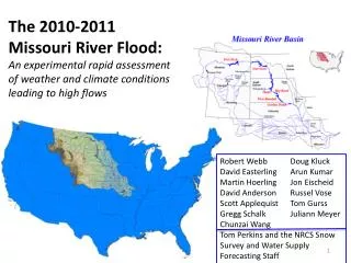
The 2010-2011 Missouri River Flood:
220 likes | 401 Vues
The 2010-2011 Missouri River Flood: An experimental rapid assessment of weather and climate conditions leading to high flows . Robert Webb Doug Kluck David Easterling Arun Kumar

The 2010-2011 Missouri River Flood:
E N D
Presentation Transcript
The 2010-2011 Missouri River Flood: An experimental rapid assessmentof weather and climate conditions leading to high flows Robert Webb Doug Kluck David EasterlingArun Kumar Martin HoerlingJon EischeidDavid Anderson Russel VoseScott Applequist Tom GurssGregg Schalk Juliann MeyerChunzai Wang Tom Perkins and the NRCS Snow Survey and Water Supply Forecasting Staff
Missouri River Basin Precipitation March-April-May 2011 Observed Seasonal Mean Precipitation(% of Normal)
January – June 2011 Observed Temperature(departure from normal) - °C March 11 April 2011 May 11 MAM 11
NOAA Soil Moisture Anomaly Analysis http://www.cpc.ncep.noaa.gov/soilmst/index_jh.html
NRCS Snowpack Maps for the Missouri River Basin Prepared by USDA Natural Resources Conservation Service, National Water and Climate Center, Portland, Oregon MAR 2011 JAN 2011 FEB 2011 MAY 2011 JUN 2011 APR 2011 http://www.wcc.nrcs.usda.gov/cgibin/misssnow.pl?state=missouri_river
Missouri River Basin Snowpack Evolution Wet Spring Caused Late Increase in Upper Basin Snowpack. Cold Spring Extended Snowpack Peaks to the end of May.
September 10 October 10 November 10 NOAA CPC Precipitation Forecast for MAM 2011 December 10 January 11 February 11
November 10 September 10 October 10 NOAA CPC Temperature Forecast for MAM 2011 February 11 December 10 January 11
NRCS Spring & Summer StreamflowForecast Maps for the Missouri River Basin MAR 2011 JAN 2011 FEB 2011 http://www.wcc.nrcs.usda.gov/cgibin/miss_strmflow.pl?state=missouri_river MAY 2011 JUN 2011 APR 2011 Prepared by USDA Natural Resources Conservation Service, National Water and Climate Center, Portland, Oregon
April to September 2011 Most Probable Streamflowfor select Missouri River Forecast Points 308 * May to September ** June to September Most Probable as a Percent of 1971 - 2000 Average NOAA Missouri Basin River Forecast Center Water Supply Statements issued in cooperation with USDA NRCS
Paleoclimate PerspectiveTree ring reconstructions of Palmer Drought Severity Index (PDSI) Wet Upper Missouri Basin Dry Wet Lower Missouri Basin Dry Year AD Interannual and decadal climate variability resulting in shifts between wet and dry conditions common over the last 1000 years Cook, E.R., et al. (2008) Data from NOAA National Climatic Data Center
Missouri River Basin: Long term Climate Trends (Jan-Dec) warming trends Year AD NOAA National Climatic Data Center
Missouri River Drainage Basin 12-month Precipitation Departures: June 2010 – May 2011 % of Climatology; Data Source PRISM 1901-2011 Time Series of June-May Missouri Basin PCPN 2010/11 Ranks Among the Top 3 Wettest Years for the Missouri Basin
Seasonality of PrecipitationSpring is the Missouri Basin’s Rainy Season But, severe Missouri River floods often stem from the combination of a prolonged wet period, rapid snowmelt, and heavy spring rains.
Spring 2011 Was Very Wet : May 2011 Second Wettest since 1901 ° Caused a Late Surge in Upper Basin Mtn Snowpack ° May 2011 Departures, % of Climatology
Spring Was Unusually Cold : Contrary to a Recent Warming Trend ° The Cold Spring Extended Snowpack Peak into May 1901-2011 Time Series of March -May Missouri Basin SfcT
La Nina Has A Strong Impact on Missouri Basin Annual Climate Precipitation Temperature
Projected Future Climate Change Impact on North American Precipitation 2080-2099Ensemble mean from 15 climate models for high emission scenario (A2) Winter Spring Summer Fall Global Climate Change Impacts in the United States. Karl, Melillo, and Peterson, (eds.), 2009.
NOAA El Niño/Southern Oscillation (ENSO) Diagnostic Discussion EL NIÑO/SOUTHERN OSCILLATION (ENSO) DIAGNOSTIC DISCUSSION issued by CLIMATE PREDICTION CENTER/NCEP 4 August 2011 ENSO Alert System Status: La Niña Watch* *Watch: Issued when conditions are favorable for the development of La Niña conditions within the next six months. • ENSO-neutral conditions are present across the equatorial Pacific. • Sea surface temperatures (SST) are near-average across the equatorial Pacific Ocean. • Atmospheric circulation anomalies still reflect aspects of La Niña. • ENSO-neutral is expected to continue into the Northern Hemisphere fall 2011, with ENSO-neutral or La Niña equally likely thereafter. • Summary From Weekly update prepared by Climate Prediction Center/NCEP 8 August 2011 http://www.cpc.ncep.noaa.gov/products/analysis_monitoring/enso_advisory/
La Niña Winter Impacts Temperature (°C) Snowfall (In) Mean composite anomalies for January/February/ March relative to the 1981-2010 average. www.cpc.ncep.noaa.gov/products/precip/CWlink/ENSO/composites/EC_LNP_index.shtml Precipitation (mm) NOAA ESRL Physical Sciences Division
Take Away Points For the Missouri River Drainage Basin : ° June 2010-May 2011 Ranked Among the Top 3 Wettest 12-month Periods Since 1901. Yet, the other 2 wettest June-May periods (1941/42 & 1998/99) did not have severe, basin wide flooding ° A Monthly Sequence of Almost Unbroken Wet Months Began in early 2010. High soil moisture content conducive to immediate runoff to streams. ° Spring (March-May) 2011 was Unusually Cold Western basin snowpack melt was deferred at least 1 month, until May 2011. ° May is a Climatological Wet Month---May 2011 was the 2nd Wettest on Record Since 1901. Heavy May rains commingled with high May snowpack, and antecedent saturated soils to induce severe flooding ° Since 1901, La Nina Has Impacted Missouri Basin Precipitation and Temperature. The 2010-11 La Nina event was very likely an important contributing factor to the flooding event.