Download
1 / 11
130 likes | 348 Vues
LOW COST AND FLEXIBLE OFFSHORE WIND MEASUREMENTS USING A FLOATING LIDAR SOLUTION (FLIDAR™ ) Wind at Sea session , EWEA 2013. sales@flidar.com | www.flidar.com | February 2013. LOW COST AND FLEXIBLE OFFSHORE WIND MEASUREMENTS USING A FLOATING LIDAR SOLUTION (FLIDAR™). BUOY

E N D
LOW COST AND FLEXIBLE OFFSHORE WIND MEASUREMENTS USING A FLOATING LIDAR SOLUTION (FLIDAR™) Wind at Sea session , EWEA 2013 sales@flidar.com | www.flidar.com | February 2013
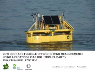
LOW COST AND FLEXIBLE OFFSHORE WIND MEASUREMENTS USING A FLOATING LIDAR SOLUTION (FLIDAR™) BUOY • Industry standard buoy with long track record • Designed for harsh environment ENERGY • Fully autonomous, solar and wind powered • Offshore components • Dimensioning for European waters • No fossil fuels, no environmental harming liquids MECHANICS Gimbal based motion stabilisation LIDAR WINDCUBE®v2 Offshore • Electronics protected with water proofing beyond standard offshore techniques for marine environment • IEC 60068-2-52 salt atmosphere compliant Data correction to account for unit motion (software) Product specifications – Technology characteristics
LOW COST AND FLEXIBLE OFFSHORE WIND MEASUREMENTS USING A FLOATING LIDAR SOLUTION (FLIDAR™) Product specifications – Measurements and Communication • Wind & Environmental Measurements • Full WindCube V2 capabilities (up to 200m height, 1Hz and 10’ averages data) • Sonic Anemometer (FLiDAR deck) • Temperature, pressure, humidity (FLiDAR deck) • Sea temperature (FLiDAR hull) • Waves and currents (under development) • Data communication • Satellite: 10’ averages once a day • GPRS: Real time full data access • Wi-Fi: Near FLiDAR operations (full data access) • Storage: On board and SFTP
LOW COST AND FLEXIBLE OFFSHORE WIND MEASUREMENTS USING A FLOATING LIDAR SOLUTION (FLIDAR™) Jul – Dec 2011 One month test next to Oostdijkbank platform 20Km offshore the Belgian coast Conditions during test: Max. significant wave height: 5m, period from 4 to 10s Wind up to 25m/s Measurement campaigns & results – Belgian trials Feb-March 2011 Near-shore Proof of concept Oostdijkbank Radar Platform
LOW COST AND FLEXIBLE OFFSHORE WIND MEASUREMENTS USING A FLOATING LIDAR SOLUTION (FLIDAR™) Measurement campaigns & results – Belgian trials
LOW COST AND FLEXIBLE OFFSHORE WIND MEASUREMENTS USING A FLOATING LIDAR SOLUTION (FLIDAR™) Measurement campaigns & results – Belgian trial - DTU report Wind speed and direction @ 100m
LOW COST AND FLEXIBLE OFFSHORE WIND MEASUREMENTS USING A FLOATING LIDAR SOLUTION (FLIDAR™) Measurement campaigns & results – Belgian trial - DTU report Accuracy deviations in 10’ averages with respect to wind direction and wind speed intensity
LOW COST AND FLEXIBLE OFFSHORE WIND MEASUREMENTS USING A FLOATING LIDAR SOLUTION (FLIDAR™) VALIDATION IN IRISH SEA AGAINST FIXED METMAST Carbon Trust Offshore Wind Accelerator Project RWE - Gwynt y Môr site Note: OWA (Offshore Wind Accelerator) is not the same as OWA (Offshore Wind Assistance)
LOW COST AND FLEXIBLE OFFSHORE WIND MEASUREMENTS USING A FLOATING LIDAR SOLUTION (FLIDAR™) Measurement campaigns & results – OWA – RWE GyM site – Carbon Trust Preliminary results from Offshore Wind Accelerator Project Wind speeds above 2m/s @ 90m (n of points >=40) Y=0.98189*x R²=0.99373 Wind direction @ 70m (n of points >=40) Y=0.96774*x R²=0.97602 • Above results are based on 1.5 days out of nearly 3 months of data collected to date • The data are processed using an offline post-processing algorithm (FLiDAR correction algorithm V2) rather than on-board (real time) algorithm on the FLIDAR
LOW COST AND FLEXIBLE OFFSHORE WIND MEASUREMENTS USING A FLOATING LIDAR SOLUTION (FLIDAR™) Summary and conclusions • FLiDAR is a highly accurate wind flow measurement device due to the combination of mechanical stabilization and software based measurement adaptation • FLiDAR is an autonomous renewable powered offshore measurement device • OWA/ GyM (Irish Sea) preliminary/ sample results show that FLiDAR measurement accuracy in wind speed is equivalent with the one obtained in the Belgian trial (r² = 0.994) • OWA/ GyMpreliminary/ sample results show that FLiDAR wind direction measurement is improved with the version 2 algorithm (r² = 0.976) • Further processing of OWA/GyM results for the full period of the trial is underway
LOW COST AND FLEXIBLE OFFSHORE WIND MEASUREMENTS USING A FLOATING LIDAR SOLUTION (FLIDAR™) THANK YOU CONTACT US FOR MORE INFORMATION: Athanasios Kyriazis Product Manager sales@flidar.com T: +32 2 217 58 68 www.FLiDAR.com SEE THE FLiDAR AT SEA: