Download
1 / 23
230 likes | 260 Vues
Discover the hydrologic cycle, groundwater distribution, and geologic impact of groundwater through features like caves, springs, and karst topography.

E N D
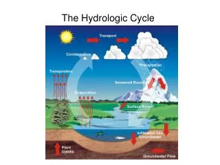
Earth as a SystemThe hydrologic cycle • Illustrates the circulation of Earth's water supply • What processes make up the water cycle?
GROUNDWATER • Largest freshwater reservoir for humans • Geological roles • An erosional agent in the formation of • Sinkholes • Caverns • Equalizes stream flow and surface water
Groundwater model • http://earthguide.ucsd.edu/earthguide/diagrams/groundwater/
Water beneath the surface (groundwater) • Distribution and movement of groundwater • Distribution of groundwater • Belt of soil moisture • Zone of aeration • Unsaturated zone • Pore spaces in the material are filled mainly with air
Water beneath the surface (groundwater) • Distribution and movement of groundwater • Distribution of groundwater • Zone of saturation • All pore spaces in the material are filled with water • Water within the pores is groundwater • Water table – the upper limit of the zone of saturation
Water beneath the surface (groundwater) • Distribution and movement of groundwater • Distribution of groundwater • Porosity • Percentage of pore spaces • Determines how much groundwater can be stored • Permeability • Ability to transmit water through connected pore spaces • Aquitard – an impermeable layer of material • Aquifer – a permeable layer of material
Water beneath the surface (groundwater) • Features associated with groundwater • Springs • Hot springs • Water is 6-9ºC warmer than the mean air temperature of the locality • Heated by cooling of igneous rock • Geysers • Intermittent hot springs • Water turns to steam and erupts
Water beneath the surface (groundwater) • Features associated with groundwater • Wells • Pumping can cause a drawdown (lowering) of the water table • Pumping can form a cone of depression in the water table • Artesian wells • Water in the well rises higher than the initial groundwater level
Water beneath the surface (groundwater) • Environmental problems associated with groundwater • Treating it as a nonrenewable resource • Land subsidence caused by its withdrawal • Contamination
Water beneath the surface (groundwater) • Geologic work of groundwater • Groundwater is often mildly acidic • Contains weak carbonic acid • Dissolves calcite in limestone • Caverns • Formed by dissolving rock beneath Earth's surface • Formed in the zone of saturation
Water beneath the surface (groundwater) • Geologic work of groundwater • Caverns • Features found within caverns • Form in the zone of aeration • Composed of dripstone • Calcite deposited as dripping water evaporates • Common features include stalactites (hanging from the ceiling) and stalagmites (growing upward from the floor)
Water beneath the surface (groundwater) • Geologic work of groundwater • Karst topography • Formed by dissolving rock at, or near, Earth's surface • Common features • Sinkholes – surface depressions • Sinkholes form by dissolving bedrock and cavern collapse • Caves and caverns • Area lacks good surface drainage