Surface processes
Surface processes. Bilingual biology and geology 3º ESO Mª Eugenia Alba Torreiro. How the Earth’s surface changes. Exogenous geological process:. Erosion, Transportation, Sedimentation.

Surface processes
E N D
Presentation Transcript
Surfaceprocesses Bilingual biology and geology 3º ESO Mª Eugenia Alba Torreiro
How the Earth’s surface changes Exogenous geological process: Erosion, Transportation, Sedimentation. • The Earth’s surface is continually being changed and shaped by different exogenous geological agents as temperature, humidity, wind, precipitation, streams and rivers, ice, seas, etc. • When these agents work on rocks of the Earth’s surface they carry out what are called exogenous geological processes: • Erosion • Transportation • Sedimentation (deposition)
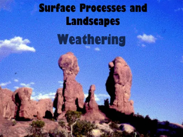
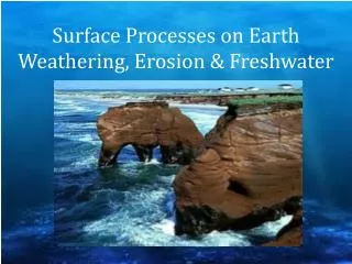
Weathering Weathering is the processes of fragmentation and alteration of rocks by the joint action of the atmosphere, water and living things. The weathering take place in two ways: Physical weathering takes place when solid rocks are fragmented by physical processes that do not change its chemical composition. Chemical weathering takes place when minerals in rocks are chemically altered or dissolved. SOIL When rocks on the Earth’s surface are weathered, they eventually produce soil. Soil formation is a very slow process which can last thousands of years.
Permanent streams and rivers They are continuous currents of water which run along a fixed channel in a valley. They are formed by rainwater, springs or melting ice and have three stages: upper course, middle course and lower course.
The stages of the rivers • Upper course • The river is closest to its source. • It usually runs down a steep slope and the water flows quickly. • There is a lot of erosion and little sedimentation. • The river valley is often narrow and V-shaped with frequent rapids and waterfalls. • Gorges and canyons are features of this stage.
Middle course • Middle course • The slope is much shallower. • The water flows more slowly: heavier materials are deposited but erosion and transportation of lighter materials continues. • Their features are: • V-shaped river valley but the slopes are less steep and the bottom is flat. The deposited sediment creates floodplains. • Meandreswhich are large bends in the river on flat terrain. • Fluvial terraces which are the remains of old floodplains when the river flowed at a higher elevation
Lower course • It is the last stage of the river. • The slope is minimal and the water flows slowly. • Meanders are large and the river valley is very wide with large floodplains. • Materials are deposited assediments. • In the river mouth, the accumulation of sediment forms deltas. • If the deltas are washes away an estuary is formed.
Karst topography • Karst is a landscape where the rocks on the Earth’s surface, usually limestone or dolomite, has been dissolved by groundwater, forming an irregular surface.
Karst topography Surface features Underground features Caves, tunnels and galleries in the rock. Stalactites, pointed columns descending from the roof. Stalagmites, pointed columns ascending from the floor. Columns, when a stalactite and stalagmite join together. • Limestone pavements, flat surfaces crossed by many fissures. • Sinkholes, depressions in the ground. • Canyons, deep channels with vertical walls.
The sea Action of waves. Waves break off fragments of rock and throw them against the coast as projectiles, increasing the erosive power of the water. This process is known marine abrasion. Action of tides. The rise and fall of the sea level is capable of transporting abundant loose materials. Action of currents. Coastal currents, which run parallel to the coast, are capable of transporting large amounts of sand and small stones.
Erosive coastal features Rocky coasts Cliffs, high and rough walls of rock formed by marine erosion due to waves breaking at their feet. Abrasion platform, a flat area at the bottom of cliffs formed by erosion of the cliffs. Caves, natural arches and stacks, are the result of different rocks which have different resistance to erosion.
Transportation and sedimentary coastal features Beach Marshes Sand bank • Beaches are formed by the accumulation of gravel and sand on the shore. • Barrier island are deposits of sand (sandbank) parallel to the coast. • Tombolos are sand banks or spits which attach small island to the coast. • Sand spits are long deposits of sands and gravels attached to the coast and formed by the longshore drift. • Lagoons are areas of water formed when sandbanks close off a bay or a gulf. • Marshes are a kind of wetland formed at the mouths of rivers by the action of the tides.
Flat-coasts Sand bank and spit Tombolo Beach Marshes
Glaciers A glacier is an enormous mass of permanent ice that forms in cold regions. It moves slowly downhill, with strong erosive power, shaping the landscape. There are two types of glaciers: ice sheets or polar glaciers and valley glaciers.
The two types of glaciers Alpine glacier Ice sheet Antarctica 14 million km2 30 million km3 of ice Greenland 1,7 million km2 2 million km3 of ice An ice sheet is a mass that covers more than 50 000 km2 of land area.
The cirque • The accumulation zone is the highest part of the glacier. • The snowaccumulates, is compacted and slowly transforms into ice. • The glacier erodes the land into an amphitheatre-shaped valley called cirque. Tarn (lake) It is a mountain lake formed in the cirque when the ice melts.
The tongue The slipping zone includes one or more tongues of ice which slide slowly downhill creating a U-shaped valley. The materials eroded and transported by the ice forms deposits called moraines. The glacier terminus is the bottom of the glacier. Here, the ice breaks and melts and deposits the transported materials. These materials form terminal moraines.
The wind The action of the wind is predominant in arid regions where precipitation is low and vegetation almost non-existent: deserts, semi deserts and beaches.
Natural arch Alveolar erostion Deflation. The removal of loose materials from the ground. Dunes