Download
1 / 1
10 likes | 167 Vues
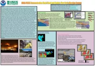
Intensive Research Areas (IRAs) – move to physical understanding. Day Fire, 2006. Santa Lucia Range, Sierra Madre, and Santa Ynez, Topatopa, Santa Susana and Santa Monica Mtns. Burned area. Harvard Fire, 2005. San Gabriel, San Bernardino and San Jacinto Mtns.

E N D
Intensive Research Areas (IRAs) – move to physical understanding Day Fire, 2006 Santa Lucia Range, Sierra Madre, and Santa Ynez, Topatopa, Santa Susana and Santa Monica Mtns Burned area Harvard Fire, 2005 San Gabriel, San Bernardino and San Jacinto Mtns Hillslope and Channel Instrumentation 1-2 years of recovery Canyon Fire, 2007 danger Fresh Fires Peninsular Ranges Rain gages Greenwood Ave, Dec 25, 2003 SMART-R Radar Truck Thresholds can vary with local conditions Or - how would we draw the map today? • San Bernardino and Ventura steepland thresholds aren’t moving with additional data Threshold rainfall conditions for flash flood and debris flow from recently burned basins in the San Bernardino Mountains ? ? ? ? ? ? ? ? ? ? ? • Rainfall Thresholds for Southern California Burned Areas (data from 2003 and 2004) • North Coast and Santa Susannas unknown • Some areas will most likely not produce debris flows • Thresholds are too low for Santa Monica Mountains and parts of the Peninsular Ranges Flash Flood Monitoring and Prediction (FFMP) The project utilizes the NWS’s Flash Flood Monitoring and Prediction (FFMP) system. Comparisons between precipitation forecasts and rainfall thresholds allow the FFMP to identify when flash floods and debris flows are likely to occur in specific basins. When precipitation amounts meet or exceeded the threshold values for a particular drainage basin, the NWS will issue a Watch or a Warning. Advisory Outlooks, Watches, and Warnings are disseminated to emergency management personnel and the public through the NWS Advanced Weather Information Processing System. Precipitation Monitoring and Forecast 40 mm of rainfall in 1.5 hour Burned area Burned area The National Weather Service (NWS) routinely forecasts and monitors precipitation events. Precipitation forecasts are for both the probability of precipitation occurring and the most likely amount. Forecasts are typically issued twice daily and updated as conditions warrant. Forecasts are derived from a number of numerical and statistical weather models as well as NWS forecaster expertise. Precipitation monitoring is conducted in real time at the local Weather Forecast Offices using rain gauge networks, NWS doppler radars, and satellite estimates. 0-25% 26-50% 51-75% 76-100% Probability of debris flow from drainages burned by the Missionary Ridge Fire near Durango, Colorado 15 mm of rainfall in 30 minutes 30 mm of rainfall in 60 minutes NOAA/USGS Demonstration Flash-Flood and Debris-Flow Early-Warning System Pedro Restrepo1, Susan Cannon2,Jayme Laber3, David Jorgensen4, Kevin Werner5 1NOAA-NWS, Office of Hydrologic Development, Silver Spring, MD USA: Pedro.restrepo@noaa.gov 2U.S. Geological Survey, Landslides Hazards Program, Golden, CO USA: cannon@usgs.gov 3NOAA-NWS, Los Angeles Weather Forecast Office, Oxnard, CA USA: jayme.laber@noaa.gov 4NOAA-OAR, National Severe Storms Laboratory, Norman, OK USA: David.E.Jorgensen@noaa.gov 5NOAA-NWS, Colorado Basin River Forecast Center, Salt Lake City, UT USA: Kevin.Werner@noaa.gov Abstract Flash floods and debris flows are common following wildfires in southern California. On 25 December 2003, sixteen people were swept to their deaths by debris flows generated from basins in the San Bernardino Mountains that burned the previous fall. In an effort to reduce loss of life by floods and debris flows, the National Oceanic and Atmospheric Administration (NOAA) and the United States Geological Survey (USGS) established a prototype flash flood and debris flow early warning system for recently burned areas located in eight counties of southern California in the fall of 2005. This prototype system combines the existing NOAA’s National Weather Service (NWS) Flash Flood Monitoring and Prediction (FFMP) system and USGS rainfall intensity-duration thresholds for debris flow and flash flood occurrence. Separate sets of thresholds are defined for the occurrence of debris flows and flash floods in response to storms during 1) the first winter after a fire, and 2) following a year of vegetative recovery. The FFMP was modified to identify when both flash floods and debris flows are likely to occur based on comparisons between precipitation (including radar estimates, in situ measurements, and short-term forecasts) and the rainfall intensity-duration thresholds developed specifically for burned areas. Advisory outlooks, watches, and warnings are disseminated to emergency management personnel through NOAA’s Advanced Weather Information Processing System (AWIPS). The FFMP provides a cost-effective and efficient approach to implement a warning system on a 24-hour, 7-day-a-week basis. In 2004 the system was advanced to incorporate a web-based procedure developed by the NWS Weather Forecast Office (WFO) in Oxnard, CA that provides information about each fire to forecasters, and displays hazard maps generated by the USGS that show those basins most likely to produce the largest debris flow events within recently burned areas. During four years of operation, the WFOs in Oxnard and San Diego issued 104 warnings, with 45 percent of these verified as having produced debris flows. Local communities and emergency response personnel have used the information provided to guide decisions for equipment deployment and evacuations. In addition to the prototype system, each year an area within the southern California study area is dedicated to intense instrumentation and research to develop new geologic, hydrologic, and hydrometeorologic methods for precipitation and debris-flow forecasting, measurement, and analysis techniques. Ongoing research to further advance the system within the USGS is focused on the development of empirical and physically-based methods for generating spatially and temporally explicit forecasts of debris-flow hazards that can integrate real-time field monitoring of hillslope and channel conditions with precipitation forecasts and measurements. Ongoing NOAA research includes improving multi-sensor precipitation estimation (from radar, rain gages and satellites) and the spatial and temporal resolution of precipitation forecasting and nowcasting techniques, and developing high-resolution hydrologic models that include soil moisture accounting procedures. Thresholds define the onset of ‘life and property threatening’ conditions Thresholds are representative of conditions over broad areas Antecedent and seasonal soil moisture effects negligible Response depends entirely on rainfall (no burn severity, slope, etc) Rainfall Thresholds To define rainfall conditions that lead to flash floods and debris flows from recently burned areas, we divided the mountainous areas of southern California into three regions based on similar geologic materials. We then compiled data on storm rainfall and the response of recently burned areas. We then compared measures of different durations of storm rainfall from storms known to have produced debris flows and flash floods with conditions in storms known to have shown no response. Those conditions that are unique to the flash flood and debris-flow producing storms define the lower limit of the danger threshold. Threshold lines delineate a range of rainfall combinations—from short duration, low peak rainfall to longer duration, higher peaks—any of which can result in flash-flood or debris-flow activity. Post-fire threshold conditions change with time as sediment supplies are depleted and vegetation recovers, and so in addition to thresholds that are useful for immediately after a fire, thresholds for the following rainy season have also been developed. Warning System Operation • Potential System Expansion • Continue to employ Intensive Research Areas to advance knowledge • Improved rainfall thresholds for smaller areas and more storm conditions • Improved radar coverage • Improved resolution of radar estimates and models for precipitation accumulations • More detailed characterizations of rainfall—i.e. polarized radar info on drop size • Provide spatially and temporally specific information as storms develop • Develop mechanistic/probabilistic models for burn and non-burn areas Extensive and severe wildfires burned more than 200,000 hectares in the San Bernardino Mountains in October of 2003. A storm on Christmas Day 2003 triggered debris flows and floods from nearly every burned basin. Sixteen people were swept to their deaths by two of these debris flows. In addition to the lives lost, $23.5 million was spent to repair flood and debris-flow damage and to remove the 4.1 million cubic meters of material deposited in debris retention basins following this event. To reduce such loss of life and property in the future by providing timely information to emergency response personnel and to the public, NOAA’s National Weather Service and the USGS partnered to establish a prototype early warning system for such events. This system combines NOAA-NWS capabilities in precipitation forecasting and measurements, and USGS experience with post-fire debris flow hazard assessments.