Download
1 / 1
20 likes | 141 Vues
Observed. Simulated. Climate Change Impacts on Pacific Northwest Hydrology: Implications for Agriculture and Water Resources Jennifer Adam and Josh Van Wie Department of Civil and Environmental Engineering, Box 642910, Washington State University, Pullman, WA 99164. 1. Introduction.

E N D
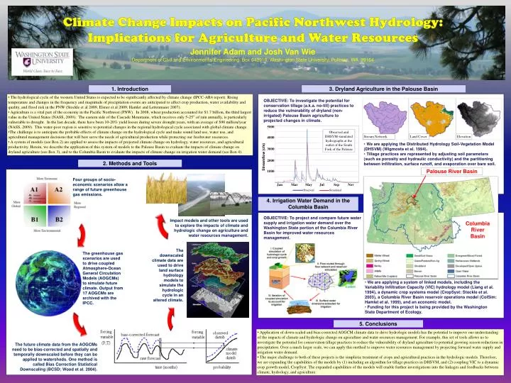
Observed Simulated Climate Change Impacts on Pacific Northwest Hydrology: Implications for Agriculture and Water Resources Jennifer Adam and Josh Van Wie Department of Civil and Environmental Engineering, Box 642910, Washington State University, Pullman, WA 99164 1. Introduction 3. Dryland Agriculture in the Palouse Basin • The hydrological cycle of the western United States is expected to be significantly affected by climate change (IPCC-AR4 report). Rising temperature and changes in the frequency and magnitude of precipitation events are anticipated to affect crop production, water availability and quality, and flood risk in the PNW (Stockle et al 2009, Elsner et al 2009, Hamlet and Lettenmaier 2007). • Agriculture is a vital part of the economy in the Pacific Northwest (PNW). In 2008, wheat production accounted for $1.7 billion, the third largest value in the United States (NASS, 2009). The eastern side of the Cascade Mountains, which receives only 5-25” of rain annually, is particularly vulnerable to drought. In the last decade, there have been 10-20% yield losses during severe drought years, with an average of $90 million/year (NASS, 2009). This water-poor region is sensitive to potential changes in the regional hydrological cycle associated with global climate change. • The challenge is to anticipate the probable effects of climate change on the hydrological cycle and make sound land use, water use, and agricultural management decisions that will best serve the needs of agricultural production while protecting our freshwater resources. • A system of models (see Box 2) are applied to assess the impacts of projected climate change on hydrology, water resources, and agricultural productivity. Herein, we describe the application of this system of models to the Palouse Basin to evaluate the impacts of climate change on dryland agriculture (see Box 3), and to the Columbia Basin to evaluate the impacts of climate change on irrigation water demand (see Box 4). OBJECTIVE: To investigate the potential for conservation tillage (a.k.a. no-till) practices to reduce the vulnerability of dryland (non-irrigated) Palouse Basin agriculture to projected changes in climate. 5000 Observed and DHSVM-simulated hydrographs at the outlet of the South Fork of the Palouse Stream Network Land Cover Elevation 4000 • We are applying the Distributed Hydrology Soil-Vegetation Model (DHSVM) (Wigmosta et al. 1994). • Tillage practices are represented by adjusting soil parameters (such as porosity and hydraulic conductivity) and the partitioning between infiltration, surface runoff, and evaporation over bare soil. 3000 Streamflow (cfs) 2000 2. Methods and Tools Palouse River Basin 1000 Four groups of socio-economic scenarios allow a range of future greenhouse gas emissions. Jan Mar May Jul Sep Nov 4. Irrigation Water Demand in the Columbia Basin OBJECTIVE: To project and compare future water supply and irrigation water demand over the Washington State portion of the Columbia River Basin for improved water resources management. Impact models and other tools are used to explore the impacts of climate and hydrologic change on agriculture and water resources management. Columbia River Basin The downscaled climate data are used to drive land surface hydrology models to simulate the hydrologic cycle in an altered climate. The greenhouse gas scenarios are used to drive coupled Atmosphere-Ocean General Circulation Models (AOGCMs) to simulate future climate. Output from 17 AOGCMs are archived with the IPCC. • We are applying a system of linked models, including the Variability Infiltration Capacity (VIC) hydrology model (Liang et al. 1994), a dynamic crop systems model (CropSyst: Stockle et al. 2003), a Columbia River Basin reservoir operations model (ColSim: Hamlet et al. 1999), and an economic model. • Funding for this project is being provided by the Washington State Department of Ecology. 5. Conclusions • Application of down-scaled and bias-corrected AOGCM climate data to drive hydrologic models has the potential to improve our understanding of the impacts of climate and hydrologic change on agriculture and water resources management. For example, this set of tools allows us to investigate the potential for conservation tillage practices to reduce the vulnerability of dryland agriculture to potential growing season reductions in precipitation. Over a much larger scale, we can apply this method to improve water resources management by projecting forward water supply and irrigation water demand. • The major challenge to both of these projects is the simplistic treatment of crops and agricultural practices in the hydrologic models. Therefore, we are expanding the capabilities of the models by (1) including an algorithm for tillage practices in DHSVM, and (2) coupling VIC to a dynamic crop growth model, CropSyst. The expanded capabilities of the models will enable further investigations into the linkages and feedbacks between climate, hydrology, and agriculture. The future climate data from the AOGCMs need to be bias-corrected and spatially and temporally downscaled before they can be applied to watersheds. One method is called Bias Correction Statistical Downscaling (BCSD; Wood et al. 2004).