ArcGIS Online Clearinghouse: Streamlining Geospatial Data Sharing Across Organizations
80 likes | 213 Vues
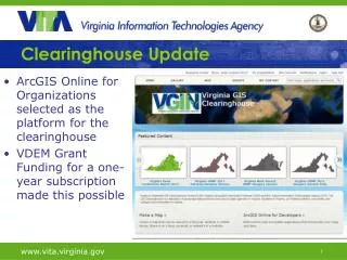
The ArcGIS Online Clearinghouse, supported by VDEM grant funding, is a cloud-hosted document management system designed to securely share geospatial data among state, local, federal, and private sector partners. Users can post and share geospatial content, allowing for selective visibility within their organization or to the general public. The platform supports various applications, including desktop software and mobile devices. A predefined user account structure facilitates easy access to shared content, enhancing collaborative efforts in geospatial project management.

ArcGIS Online Clearinghouse: Streamlining Geospatial Data Sharing Across Organizations
E N D
Presentation Transcript
Clearinghouse Update • ArcGIS Online for Organizations selected as the platform for the clearinghouse • VDEM Grant Funding for a one-year subscription made this possible
ArcGIS Online for Organizations- AGOLO • Cloud-hosted document management system for geospatial data • Secure system for sharing with authorized state, local, federal and private sector partners • Selected items can also be made available to the general public • Content includes downloadable data, links to external web services, hosted services, and apps • Total solution a blend of locally hosted services and ESRI services.
The VGIN AGOL Organization • User accounts will be pre assigned • Initially, one general user per entity (local government, state agency, others) upon request (e.g. VGIN.Chesterfield) • Will allow the user to post geospatial content to the clearinghouse • User can choose to share their data with • All others in the organization • Select groups within the organization • Select groups outside the organization • The general public
Content can be used in many apps Desktop software Web map viewers Embedded maps Smart phones/tablets Other mobile devices
AGOLO Subscription Limits • Currently limited to 250 users • 137,500 service credits • Credits are consumed by storage costs, downloads, and hosting services
Clearinghouse Usage Guidelines • Sharing of data by download - use freely • Layer packages • Map packages • Shapefiles (w/o feature service) • Register services published by your ArcGIS Server • Use freely • Hosted Services (coordinate with VGIN before using) • Feature services • Tiled cache services • Geocoding
Clearinghouse User Guidelines • Hosted Services • coordinate with VGIN before using • Feature services • Tiled cache services • Geocoding
Questions or Comments? John Scrivani – VGIN John.scrivani@vita.virginia.gov