Download
1 / 50
540 likes | 1.22k Vues
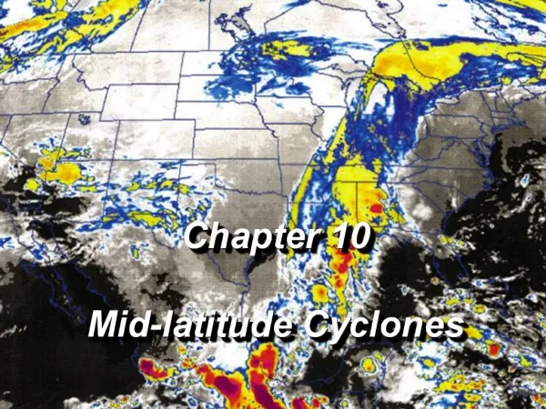
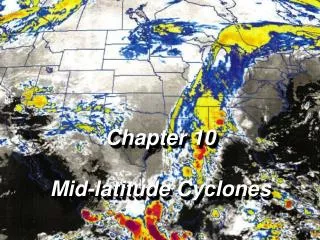
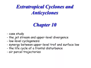
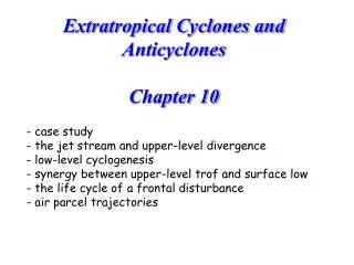
Extratropical Cyclones and Anticyclones Chapter 10. case study the jet stream and upper-level divergence low-level cyclogenesis synergy between upper-level trof and surface low the life cycle of a frontal disturbance air parcel trajectories. the Edmund Fitzgerald. 9 Nov 1975.

E N D
Extratropical Cyclones and AnticyclonesChapter 10 • case study • the jet stream and upper-level divergence • low-level cyclogenesis • synergy between upper-level trof and surface low • the life cycle of a frontal disturbance • air parcel trajectories
the Edmund Fitzgerald 9 Nov 1975 Fig. 10.2
the crew Fig. 10.3
8 Nov 7 am Fig. 10.5
9 Nov 7 am Fig. 10.7
Evolution of fronts 9 Nov 6 am 9 Nov 3 pm Fig. 10.10
10 Nov 7 am Fig. 10.14
Fitzgerald lost at sea, 10 Nov 7 pm Fig. 10.17
Strong northwesterly winds, long fetch … large waves Fig. 10.16
11 Nov 7 am Fig. 10.18
Remember from chapter 3… • Net radiation R is greatest at tropics, least at poles. We will now discuss how this poleward heat transfer is accomplished in mid-latitudes …
300 mb cold warm
The jet stream is there because of low-level temperature differences polar front jet (PFJ) temperature jet stream winds
The jet stream and surface weather • The jet stream is consistent with a large horizontal temperature gradient (the atmosphere is baroclinic). • The jet stream has waves, called Rossby waves • These waves may first form in the lee of mountains (lee cyclogenesis) • These waves propagate, and are unsteady • The shorter waves are important for weather at the surface, because • UL divergence occurs ahead of the Rossby trof • UL convergence occurs behind the Rossby trof • UL divergence causes uplift, and cyclogenesis near the surface. • These waves, in turn, are affected by the low-level cyclogenesis. • The evolution of midlatitude frontal disturbances is understood by the synergy between UL wave evolution, and LL cyclone evolution (baroclinic instability).
Remember the causes of uplift, and cloud & precipitation: • Buoyant ascent [bubble ascent] • Forced ascent [layer ascent] • Orographic • Frontal • Low-level convergence (friction) • Upper-level divergence (jet stream) Fig. 10.11
300 mb height, 9 Nov 1975, 7 pm Find the trofs Fig. 10.13
surface low 300 mb height, 9 Nov 1975, 7 pm Fig. 10.13
Two mechanisms for upper-level divergence • changes in wind speed due to Rossby waves • jet streak: small region in the jet stream with strong winds
1. Rossby waves: remember from Chapter 6 .... The jet stream wind is subgeostrophic in trofs, and supergeostrophic in ridges slow fast fast slow
from chapter 9: gradient wind balance (PGF, Coriolis force, and centrifugal force) CFF PGF PGF Coriolis CFF Coriolis faster-than-geostrophic wind (supergeostrophic) slower-than-geostrophic wind (subgeostrophic)
Rossby waves fast fast slow
mid-latitude frontal disturbances:interaction between the low-level and the jet-level flow SL pressure and precipitation 300 mb height and wind speed warm cold
upper-level chart surface chart
12 hrs later The movement and evolution of the frontal system is tied to those of the UL trof.
Developing frontal lows tilt westward with height surface low upper-level trof
fast fast slow Note the advection of cold and warm airmasses
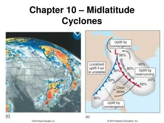
Norwegian cyclone model Precursor conditions: frontogenesis along a developing front I. early open wave stage: A kink on the front will form as an upper level disturbance embedded in the jet stream moves over the front. Distinct regions of warm & cold air advection form.
Norwegian cyclone model II. late open wave stage: cold and warm fronts become better organized. III: mature (occluding) stage: As the cold front overtakes the warm front, an occluded front forms. Effectively, the low moves into the cold air, and warm air is drawn into the elevated wedge (trof aloft or “trowal”)
Norwegian cyclone model IV: dissipating stage: the occlusion increases and eventually cuts off the supply of warm moist air, causing the low pressure system to gradually dissipate.
Evolution of a frontal disturbance: the Norwegian cyclone model stationary polar front (trof) 1. early open wave stage 2. late open wave stage 3. mature (occluding) stage 4. dissipating stage
early open wave mature Upper-level height contours 1 3 Note displacement of upper-level trough to west of surface low late open wave dissipating 2 4
Relationship between surface cyclone and UL wave trof, during the lifecycle of a frontal disturbance 500 mb height (thick lines) SLP isobars (thin lines) layer-mean temperature (dashed) The deflection of the upper-level wave contributes to deepening of the surface low.
How does a low form in the first place? It can form along a polar front, from scratch. Over land, it often forms in the lee of mountains: lee cyclogenesis Box 10.1
Conservation of angular momentum slow spin fast spin fast spin regions of frequent cyclogenesis Alberta low Colorado low Fig. 7.8
Satellite Views of Wave Cyclones occluded front warm front cold front warm sector 2. open wave stage, with clouds over warm and cold fronts, with clear warm sector 3. occluding stage 4. dissipating stage From Hobbs
occluding stage dissipating stage From Cotton and Anthes
conveyor belts: air parcel trajectories 1. “dry-tongue jet”: descending cold air behind cold front Box 10.3
conveyor belts 2: warm conveyor belt: ascending warm, most air ahead of cold front, over the warm front. 3. cold conveyor belt: ascending cold, moist air drawn into the occluding storm. 3. Ascending cold conveyor belt 1. Subsiding dry-tongue jet 2. ascending warm conveyor belt From Palmen and Newton, p. 310
Pop quiz • When an upper-level low is right above the surface low, • A: the system is occluded & dissipating • B: the system is in open-wave stage • C: the system is in the initial stage • D: the system must be a tropical cyclone
Summary: how a mid-latitude frontal disturbance works • The jet stream is consistent with a large horizontal temperature gradient (the atmosphere is baroclinic). • The jet stream has waves, called Rossby waves • These waves may first form in the lee of mountains (lee cyclogenesis) • These waves propagate, and are unsteady • The shorter waves are important for weather at the surface, because • UL divergence occurs ahead of the Rossby trof • UL convergence occurs behind the Rossby trof • UL divergence causes uplift, and cyclogenesis near the surface. • These waves, in turn, are affected by the low-level cyclogenesis. • Warm advection ahead of the surface low builds the UL ridge • Cold advection behind the surface low deepens the UL trof. • The evolution of midlatitude frontal disturbances is understood by the synergy between UL wave evolution, and LL cyclone evolution (baroclinic instability). • Finally, the raison d’étre of these frontal disturbances is to transfer heat poleward …