Download
1 / 67
730 likes | 2.02k Vues
Cyclones and Anticyclones in the Mid-Latitudes. Val Bennington November, 2008. Anticyclones. High pressure systems Just air masses with temperature and moisture varying slightly over large area Clear, calm, pretty dry Blob-like, with small pressure gradients and slower winds. Anticyclone.

E N D
Cyclones and Anticyclonesin the Mid-Latitudes Val Bennington November, 2008
Anticyclones • High pressure systems • Just air masses with temperature and moisture varying slightly over large area • Clear, calm, pretty dry • Blob-like, with small pressure gradients and slower winds
Anticyclone (High) • Which way does the wind blow? • Does air diverge or converge at the surface? • Does air converge or diverge above the high?
Anticyclone (High) • Which way does the wind blow? --> anti-cyclonic = clockwise! • Does air diverge or converge at the surface? -->Diverges! • Does air converge or diverge above the high? -->Converges!
Anticyclones (Highs) • Generally boring weather - clear, calm • Linger for a while, but can be nice • Trap air near surface (sinking motion) • Blob-like air masses • Air mass stays long can take on characteristics of land it is over
Fronts • What about when two air masses meet? • We get a front - large changes in temperature and moisture over small area
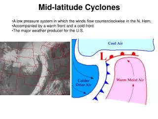
What is a Cyclone? • A cyclone is simply an area of low pressure around which the winds flow counterclockwise in the Northern Hemisphere and clockwise in the Southern Hemisphere • Cyclones form and grow near the front • Cyclones (lows) are cloudy, wet, stormy
COLD FRONTS Cold Front • A transition zone where a cold air mass replaces a warm air mass • Drawn as a blue line with blue triangles pointing in the direction of the front’s movement
Cold Fronts Cold Front • Cold air is more dense than warm air! • As the dense, cold air moves into the warm air region, it forces the warm air to rapidly rise just ahead of the cold front. • This results in deep convective clouds, occasionally producing strong to severe thunderstorms (depending on how unstable the atmosphere ahead of the cold front is). • Often, the precipitation along a cold front is a very narrow line of thunderstorms
Warm Fronts Warm Front • A transition zone where a warm air mass replaces a cold air mass • Drawn as a red line with red half-circles pointing in the direction of the front’s movement • TEMPERATURE CONTRAST ALONG WARM FRONTS IS GENERALLY LESS DISTINCT (SMALLER GRADIENT)
Warm Fronts Warm Front • Again, warm air is less dense than cold air. • As the warm air moves north, it slides up the gently sloping warm front. • Because warm fronts have a less steep slope than cold fronts, the precipitation associated with warm fronts is more “stratiform” (less convective), but generally covers a greater area.
Occluded Fronts Occluded Front • A region where a faster moving cold front has caught up to a slower moving warm front. • Generally occurs near the end of the life of a cyclone • Drawn with a purple line with alternating semicircles and triangles
Stationary Fronts • Front is stalled • No movement of the temperature gradient • But, there is still convergence of winds, and forcing for ascent (and often precipitation) in the vicinity of a stationary front. • Drawn as alternating segments of red semicircles and blue triangles, pointing in opposite directions
Locating Fronts Fronts are associated with . . . • Strong temperature gradients • Positive vorticity (counter-clockwise rotation) • Lower pressure • Regions of convergence of the winds • Often precipitation and clouds (regions of ascent)
Locating Fronts Here, the winds are rapidly changing counterclockwise across this temperature gradient. The winds are blowing warm air from the south. This is awarm front.
Locating Fronts In this case, the winds are also rapidly changing counterclockwise across this temperature gradient, indicating positive vorticity. The winds are blowing cold air from the northwest. This is acold front.
Locating Fronts • To find the cyclone: • Find the center of cyclonic circulation • To find the fronts: • Find large temperature gradients • Identify regions of wind shifts • Look for specific temperature advection (warm/cold) • Look for kinks in the isobars (regions of slightly lower pressure)
Locating Fronts • To find the cyclone: • Find the center of cyclonic circulation • To find the fronts: • Find large temperature gradients • Identify regions of wind shifts • Look for specific temperature advection (warm/cold) • Look for kinks in the isobars (regions of slightly lower pressure)
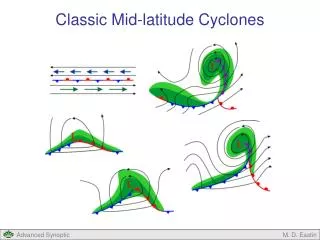
The Birth of a Cyclone • A mid-latitude cyclone is born in a region where their is a strong temperature gradient with forced lifting, perhaps an old stationary front • At the polar front!
Stage Two • An instability (kink) forms • Warm air pushes to the northeast • Cold air pushes to the southwest • This will create the fronts!
Mature Stage • Takes 12-24 hours to develop • Warm front moves NE • Cold front moves SE • Region between fronts called warm sector • Low pressure lowers (deepens) • Wide-spread precip ahead of warm front • Narrow band of precip at cold front • Wind speeds increase
Cyclone Movement • Cyclone moves eastward (or to NE) • Starts to occlude (cold front catching up) • Storm most intense • Triple point is where cold, warm, and occluded fronts meet
Final Stage • Warm sector shrinks • Occlusion grows • All energy from temperature contrast has been used up • Warm air has been lifted • Cold air has sunk • STABLE
Precipitation Around a Cyclone and its Fronts To the right is a major cyclone that affected the central U.S. on November 10, 1998. Around the cold front, the precipitation is more intense, but there is less areal coverage. North of the warm front, the precipitation distribution is more “stratiform”: Widespread and less intense. http://weather.unisys.com
Precipitation Around a Cyclone and its Fronts Again, in this radar and surface pressure distribution from December 1, 2006, the precipitation along the cold front is much more compact and stronger. North of the warm front, the precipitation is much more stratiform. Also note the kink in the isobars along the cold front!
Locating a Cyclone • Find the region of lowest sea level pressure • Find the center of the cyclonic (counter-clockwise) circulation L
Pressure… • If we have converging air at the surface, must have divergence aloft! • Otherwise, air would “fill up” the low and the pressure would rise
Review • Winds converge at a surface low pressure center • Winds diverge from a surface high pressure center (this is because of thefrictional forceat the surface) • This Convergence/Divergence suggests that there must be movement of air in the vertical (can’t lose air parcels) • Flow in the upper troposphere is generally ingeostrophic balance, so we do not get divergence/convergence high up caused by friction • How do we get divergence/converge up high?
Upper Tropospheric Flow • Typical 500 mb height pattern • Notice the troughs (dotted line) and ridges • The troughs and ridges are successive • In the northern hemisphere, lower pressure is generally to the north of higher pressure
Relative Vorticity If the wind has counterclockwise spin, it haspositive vorticity(left) If the wind has clockwise spin, it hasnegative vorticity(right) Vorticity can be directional (top), or speed shear vorticity (bottom)
Vorticity in the Upper Troposphere Where is there vorticity advection? Pinpoint vorticityminimaandmaxima. Negative vorticity advection (NVA) occurs just “downstream” from a ridge axis (vorticity minimum) Positive vorticity advection (PVA) occurs just “downstream” from a trough axis (vorticity maximum)
Vorticity Advection and Vertical Motion * Positive vorticity advection (PVA) results indivergenceat that level * Negative vorticity advection (NVA) results inconvergenceat that level
Vorticity Advection and Vertical Motion Remember thatconvergenceat upper levels is associated with downward vertical motion (subsidence), anddivergenceat upper levels is associated with upward vertical motion (ascent). Then, we can make the important argument that . . .
Upper Tropospheric Flow and Convergence/Divergence • Downstream of an upper tropospheric ridge, there is convergence, resulting in subsidence (downward motion). • Likewise, downstream of an upper tropospheric trough, there is divergence, resulting in ascent (upward motion).
Upper Tropospheric Flow and Convergence/Divergence • Downstream of an upper tropospheric ridge axis is a favored location for asurface high pressure. • Downstream of an upper tropospheric trough axis is a favored location for asurface low pressurecenter.
Upper Tropospheric Flow and Convergence/Divergence • Surface cyclones move in the direction of the upper tropospheric flow! • The storm speed and direction can also be identified on the 500 mb map. Cyclones move in the direction of the 500 mb flow, the 500 mb flow is also called the steering flow. The cyclone also moves at about half the speed of the 500 mb flow. • The surface low pressure center in diagram above will track to the northeast along the upper tropospheric jet (along the surface temperature gradient)
Vertical Structure of Cyclones • What else do these diagrams tell us? • Surface cyclone is downstream from the upper tropospheric (~500 mb) trough axis • Mid-latitude cyclones generally tilt westward with height!
Vertical Structure of Cyclones • 500 mb positive vorticity advection causes divergence and ascent • This induces a surface cyclone • Cyclone formation occurs because of this upper-level divergence!
Longwaves and Shortwaves • The flow in the upper troposphere is characterized as having . . . • Longwaves: There are typically 4-6 of these around the planet. The longwave pattern can last for as long as 2-3 weeks on occasion, and can result in long periods of anomalous weather • Shortwaves: Embedded in the longwave pattern are smaller scale areas of high vorticity (lots of curvature). They move quickly east within the longwaves, and generally strengthen when they hit a longwave trough. Often, shortwaves result in huge “cyclogenesis” events such as nor-easters or midwest snowstorms.
Longwaves vs. Shortwaves • To the left is a North Pole projection of 300 mb heights (contoured) and wind speed (colors) • North Pole is at the center, equator is at the edges • Note the prominent longwave troughs and ridges---especially over North America LONGWAVE TROUGH