Space Geodesy
Space Geodesy. Chopo Ma Planetary Geodynamics Laboratory Goddard Space Flight Center Chair International Earth Rotation and Reference Frames Service (IERS) Executive Committee Global Geodetic Observing System (GGOS) Directing Board

Space Geodesy
E N D
Presentation Transcript
Space Geodesy Chopo Ma Planetary Geodynamics Laboratory Goddard Space Flight Center Chair International Earth Rotation and Reference Frames Service (IERS) Executive Committee Global Geodetic Observing System (GGOS) Directing Board International VLBI Service for Geodesy and Astrometry (IVS)
Current Missions LAGEOS, Etalon, Starlette, Stella, BE-C, Ajisai Jason-1, Envisat, ICESat, ERS-2, GFO-1 GRACE, CHAMP GPS, GLONASS, GIOVE ANDE-RR, ETS-8, LARETS COSMIC Benefits to Earth Science Research Sea level changes Ice budget Terrestrial deformation Earthquakes NASA’s Space Geodesy Networks:Supported Missions and Resulting Benefits • Recent Missions • TOPEX/Poseidon • GP-B • Meteor-3M • Future Missions • Jason-2 • ICESat-2 • GRACE-2 • DESDynI • LIST • GNSS occultation • Atmospheric sounding • Ocean circulation • Mass transport • Climate change Space Geodesy Overview
Terrestrial Reference Frame (TRF) • An accurate, stable set of positions and velocities. • Provides the stable coordinate system that allows us to link measurements over space, time and evolving technologies. • Essential for tracking and interpreting flight missions. • Foundation for virtually all space-based and ground-based observations. • Measuring sea level rise requires stability of 0.1 mm/yr. • Established and maintained by the global space geodetic networks. • Network measurements must be precise, continuous, and worldwide. Space Geodesy Overview
Geodetic Networks • Provide the critical capabilities necessary to maintain the TRF in support of the Earth science goals and missions • Include: • physical networks • technologies that compose them • scientific models that define a TRF • Must be robust: • reliable • geographically distributed • proper density over the continents and oceans • interconnected by co-location of different observing techniques Space Geodesy Overview
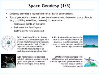
Space Geodesy Techniques • SLR/LLR Satellite/Lunar Laser Ranging • VLBI (Very Long Baseline Interferometry) • GNSS (GPS, GLONASS, future: Galileo) • DORIS (Doppler Orbitography and Radio Positioning Integrated by Satellite) SLR/LLR DORIS VLBI GNSS/GPS Space Geodesy Overview
Why do we have multiple techniques? • High precision geodesy is very challenging • 0.1 mm/yr required for sea level • Fundamentally different observations with unique capabilities • Together provide cross validation and increased accuracy for TRF • Well-distributed co-location and accurate ties required • Strength from improvement of techniques and integration of techniques Space Geodesy Overview
Impact of Reference Frame on Regional Mean Sea Level Rates TOPEX MSL Rates 1993-2001 ITRF2005 (GGM02c) - CSR95 (JGM3) Space Geodesy Overview
The SLR Technique Precise direct range measurements to satellites Least dependent on transmission media Passive space segment Near real-time global data availability Ability to detect variations in long-term trends Science and Applications Terrestrial Reference Frame (Center of Mass and Scale) Static and time-varying coefficients of the Earth's gravity field Earth mass distribution Earth Orientation Parameters (EOP) Accurate satellite ephemerides: POD calibration and validation of altimetry missions Backup Precise Orbit Determination (POD) Saved missions (ERS-1, GFO-1, Meteor-3M, last years of TOPEX/Poseidon) SLR Unique Capabilities Space Geodesy Overview
Co-Location in Space • Retroreflectors on GPS-35, -36, GIOVE-A (Galileo), and GLONASS • Effort underway to have Air Force place retroreflectors on GPS-III • Studies underway to reduce size and weight of arrays • INFN (Italy) agreed to provide environmental testing • Absolute validation of tracking techniques and spacecraft models • Resolve issues about the origin and scale of the ITRF Space Geodesy Overview
What do the geodetic networks do for NASA? • Directly measure Earth science parameters • e. g., volcanic and tectonic deformations, gravity field, Earth rotation • Provide the accurate TRF for the interpretation of satellite observations • e. g., altimetry for sea level rise and cryosphere change • Provide precise determination of satellite orbits and critical information for accurate deep space navigation • Networks provide essential capability to support flight projects • Support is assumed by current and future missions yet is rarely budgeted or planned • NASA network components are deteriorating and must be rejuvenated Space Geodesy Overview
Global Space Geodetic Networks(SLR/LLR, VLBI, GNSS) • Unbalanced geographic distribution • Inadequate co-locations • Declining NASA network contribution • NASA leverages worldwide networks Space Geodesy Overview
What are the Geodetic Services? • Parts of the International Association of Geodesy (IAG) • An example of Community Management Model • Self-regulating, develop standards, monitor performance • Define and deliver products • 200+ Organizations in 80+ countries • NASA actively participates in the services • International GNSS Service (IGS) • International Laser Ranging Service (ILRS) • International VLBI Service for Geodesy and Astrometry (IVS) • International DORIS Service (IDS) • Activities are supported by the Crustal Dynamics Data Information System (CDDIS) • Services respond to NASA’s program needs • NASA leverages its resources by cooperating with international partners Space Geodesy Overview
GGOS Global Geodetic Observing System Based on the IAG Services, GGOS has been accepted as a member of GEO, GEOSS and IGOS-P. Goals: • To collect, archive and ensure the accessibility of geodetic observations and models through the IAG Services; • To ensure the robustness of the three fundamental fields of geodesy: geometry, orientation, and gravity; • To identify a consistent set of products and establish requirements concerning its accuracy and reliability; • To promote and improve the visibility of the research in geodesy; • To achieve maximum benefit for the scientific community and society in general. NASA contributes to GEO through space geodesy. Space Geodesy Overview
Fundamental Station Co-Location System SLR VLBI GPS Gravimeter DORIS Space Geodesy Overview