Download
1 / 35
350 likes | 520 Vues
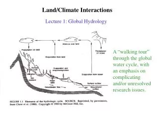
Land/Climate Interactions. Lecture 1: Global Hydrology. A “walking tour” through the global water cycle, with an emphasis on complicating and/or unresolved research issues. Issue: Imperfect knowledge of the globally-averaged fluxes. Two different estimates (even after normalization):.

E N D
Land/Climate Interactions Lecture 1: Global Hydrology A “walking tour” through the global water cycle, with an emphasis on complicating and/or unresolved research issues.
Issue: Imperfect knowledge of the globally-averaged fluxes. Two different estimates (even after normalization):
Issue: The components of the water cycle operate at different timescales...
…and different spatial scales “Opportunities in the hydrologic sciences”, National Academy Press, 1991 “A Plan for a New Science Initiative on the Global Water Cycle”, USGCRP, 2001
Issue: The global water balance is inextricably tied to the global energy balance. + latent heat release during condensation in atmosphere
Issue: measurements of the global water balance are far from perfect. Precipitation, a relatively well-measured hydrological field, is still not known with certainty. Two alternative, state-of-the-art estimates disagree in places
1. Precipitation events can easily be missed by raingauges. 2. Structure of precipitation events is critical. In these events, the average rain depth over the catchment is about the same, yet the hydrological response will differ markedly. Fennessey et al., Ralph M. Parsons Tech Report 307, MIT, 1986
Evaporation, a critical element of the hydrological cycle, can only be roughly estimated on the global scale. One approach: determine evaporation by forcing a land surface model with observed meteorological data
In situ soil moisture measurements are spotty and are not global. Satellite soil moisture measurements are global but only access the top millimeters of soil. Modeled soil moisture reflects observed antecedent forcing but is limited by realism of model used. Global Soil Moisture Data Bank: http://climate.envsci.rutgers.edu/soil_moisture/index.html
Validation: Standard Error~3% Soil Moisture Mapping and Single Channel Algorithm Validation Using ESTAR in SGP97
Difference [m3/m3] Satellite vs. model surface soil moisture (1979-87)
Runoff integrates hydrological response over large areas. Data is not compete, however, and communication between data centers is less than perfect. Active streamgages operated by the USGSStreamgages currently operated by other agencies and in the NSIP planStreamgages that are inactive, to be reactivated in the NSIP planProposed new streamgages in NSIP Plan Global Runoff Data Center
Issue: realistic modeling is difficult. Simple models of soil moisture transport, commonly used in today’s models... … ignore tremendous complexity below the surface 100s of km
Models often go to great lengths to characterize the evaporation process properly. Nevertheless, different models, forced with the same met. data, produce different evaporation rates. Bowling, PILPS 2-e
Two critical roles for a land surface model: Partition incoming radiative energy into latent heat, sensible heat, heat storage, and outgoing radiative energy Partition precipitation into evaporation, runoff, and water storage. Proper land surface modeling has many potential benefits. It will be the focus of much of the first part of this course.
Precipitation, a relatively well-measured hydrological field, is still not known with certainty. Two alternative, state-of-the-art estimates disagree in places GCMs can be way off!
Different AGCMs OBS
Issue: variations in the global water cycle can have tremendous impacts on society, yet they often can’t be predicted. 1) Floods “During 1991-1995, flood related damage totaled more than US$200 billion (not inflation adjusted) globally, representing close to 40% of all economic damage attributed to natural disasters in the period.” (Pileke Jr. and Downton, 2000, citing IFRCRCS, 1997) 1993 Mississippi River flood
Impacts of floods and droughts have been known for a long time... 2) Droughts Droughts can be expensive: --1988 midwest drought: $40 billion -- 1998 southern U.S. drought: $6 to 9 billion Drought near Bracketville, Texas, in 1980
Predictions of water cycle variations, however, are gradually becoming better, largely through the development of earth system models and improved understanding of phenomena like El Nino. prediction observed
Background photograph (taken by Philipp Hoelzmann) shows rock paintings of mid-Holocene fauna near Zolat el Hammad, North Sudan. Today this region, like the largest part of the Sahara, is a hyperarid desert. The desert formed some 5,000 to 6,000 years ago. Ensemble simulations using a coupled atmosphere-ocean-vegetation model reveal a rather abrupt change in Saharan vegetation (superimposed blue lines indicate fractional vegetation cover), which was triggered by subtle changes in Northern hemisphere summer insolation (Claussen et al.,1999). Issue: because our observational record is limited, we don’t have a full characteriza-tion of the variability of the water cycle -- we don’t necessarily know what nature will throw at us in the years to come. “A Plan for a New Science Initiative on the Global Water Cycle”, USGCRP Figure 2. Winter-spring precipitation reconstructed from tree ring data, Durango, Mexico (normalized and smoothed to highlight decennial variability). The tree-ring estimates explain 56% of the variance in precipitation for Durango and are consistent with independent precipitation data. This reconstruction is well correlated with the all-Mexico rainfall index (r = 0.76; p < 0.001) and with precipitation over north central Mexico, where the cocoliztli epidemics appear to have been most severe. Note the unprecedented 16th-century megadrought during both cocoliztli epidemics. Megadrought and Megadeath in 16th Century Mexico, Rodolfo Acuna-Soto,* David W. Stahle, † Malcolm K. Cleaveland,† and Matthew D. Therrell
Issue: certain components of the global water cycle contain information about past climate. Ice cores Groundwater Phillips et al., 1986
Issue: Humans may be modifying the global water cycle in significant ways. Stan Leake and Dave Goodrich, via“A Plan for a New Science Initiative on the Global Water Cycle”, USGCRP
1986 1973 Observations: Glacier Extent 1986 1973 Retreat of Muir Glacier, from Landsat
Global warming may or may not be affecting or even “accelerating” Earth’s hydrological cycle. Some evidence is suggestive... …whereas other evidence appears to fly in the face of model predictions.
Issue: predictions often are made at large scales, but sociological impacts tend to occur at much smaller scales. How do we translate predictions between scales? Nesting climate and hydrologic models. A coupled ocean-atmosphere model is used to compute global sea surface temperatures (SSTs), which are transferred as input, along with the land-surface state, to a global atmospheric model. The global model output drives a large-scale atmospheric circulation model, whose output serves as an input to a regional atmospheric dynamics model. This regional model computes surface temperature, precipitation, and other radiation components which, when spatially disaggregated, and upon specifying the land state again at basin resolution, provide the input for a basin-scale coupled hydrology-ecosystem model. The hydrologic model predictions along with risk statistics can provide input to a complex decision making process. “Shukla staircase”, printed in“A Plan for a New Science Initiative on the Global Water Cycle”, USGCRP, 2001
Issue: the global water cycle is strongly tied to global geochemical cycles. Water is the “universal solvent”. “Societal Need: Understanding the links among the C, N, and water cycles in terrestrial and inland aquatic systems and the factors driving the human activities that impact vegetation distribution and water quality.” “A Plan for a New Science Initiative on the Global Water Cycle”, USGCRP
La Conchita mudslide, January 2005 (photo taken off web. AP?)
Issue: the global water cycle is strongly linked to global ecological distributions. Wang and Eltahir Eagleson and Segarra http://www.tkl.iis.u-tokyo.ac.jp/RGOE/actual.html
Issue: the global water cycle is a strong control on human society. Annual precipitation field Population density Oki, 2002
Issue: the global water cycle includes the ocean. The terrestrial branch of the water cycle can affect the ocean circulation.
Issue: How do we take best advantage of the new kinds of data (particularly satellite data) now being made available?
Issue: Hydrological science may have extraterrestrial relevance! Methane river channels on Titan “European Space Agency scientists report the first look at data from Huygens' descent and landing on Titan shows the Saturnian moon has Earth-like geophysical processes operating on exotic materials in very alien conditions. (Jan. 21)”
“A Plan for a New Science Initiative on the Global Water Cycle” by the USGCRP Water Cycle Study Group Three science questions: 1. What are the causes of water cycle variations on global and regional scales? 2. To what extent are these variations predictable? 3. How are water and nutrient cycles linked? Three “pillar initiatives”: 1. Determine whether the global water cycle is intensifying and, if so, to what degree human activities are responsible. 2. Extend the science to decrease the costs of water cycle calamities (droughts, floods, eutrophication, etc.) 3. Develop the ability to predict the effects of changes in land use, land cover, and cryospheric processes on the cycling of water and associated geochemical constituents.
Lectures Intro: Land & Climate / Global HydrologyThe Surface Energy BalanceThe Surface Water Balance Radiation & Turbulence Land Surface Parameterizations (part 1) Land Surface Parameterizations (part 2) Land Surface Parameterizations (part 3)Comparisons of LSMs Land and Climate: Modeling Studies Land and Climate: Observational Studies Land Use – Land Cover Change Natural Variability of the Land Surface Long-Term Vegetation Changes Introduction } Basic constraints on land surface behavior; simple modeling approaches. } Structure and performance of land surface models used with today’s GCMs. } Role of the land surface in the climate system.