Download
1 / 27
341 likes | 820 Vues
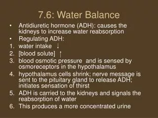
Groundwater . Crop Water Balance. Colin S. Campbell, Ph.D. Decagon Devices. Water Balance. Water in – water out = water stored Water in Precipitation (irrigation) Water out Infiltration (deep drainage) Evapotranspiration Runoff Water stored Soil water content

E N D
Groundwater Crop Water Balance Colin S. Campbell, Ph.D. Decagon Devices
Water Balance • Water in – water out = water stored • Water in • Precipitation (irrigation) • Water out • Infiltration (deep drainage) • Evapotranspiration • Runoff • Water stored • Soil water content • Precip – deep drainage – ET – Runoff = water storage in root zone
Soil Water Cycle (100 cm precip. with vegetative cover) transpiration 40 cm 100 cm Precipitation, dewfall (or irrigation) evaporation 10 cm runoff 15 cm Drainage Storage (soil moisture) 35 cm Groundwater
Upper boundary Precipitation/Irrigation • Precipitation • rainfall, snowfall • Irrigation • Sprinkler, drip, etc.
Upper boundary Runoff • A significant portion of precipitation on the soil surface may not be absorbed • Dependent on precipitation/snowmelt intensity • Topography • Ground cover/vegetation
Upper boundary Evapotranspiration (ET) • ET Covers all water loss to the atmosphere • Evaporation (E) • Direct soil to atmosphere transfer • Dominant process over bare soil or sparse vegetation (energy available for evaporation) • Severely retarded by a layer of dry soil or mulch between wet soil and atmosphere • Vapor diffusion slow • Plant canopy decreases E dramatically
Upper boundary Evapotranspiration • Transpiration (T) • Occurs via plants • Dominates over moderately and densely vegetated surfaces (shade soil from radiation) • Draws water from deeper in the soil profile • Unaffected by dry surface layer
Lower BoundaryDrainage • Drainage - water that percolates past root zone • Very little brought back up by capillary rise • Most percolates down into groundwater • Traditionally difficult to measure • Very important parameter for • Water balance • Aquifer recharge • Groundwater contamination
Measurement Upper boundary • Precipitation • Variety of gauges available for different price and accuracy/resolution needs • Not as easy to measure as many people think • Irrigation • Above ground (sprinkler, etc) • Rain gauge will work for both precipitation and irrigation • Below ground (drip, etc.) • In some cases, it is possible to measure application water with a flow meter • Other cases require reliance on water content monitoring
Measurement Upper boundary • Runoff • Catchment flow (measure stream flow)– ecosystem scale studies • Runoff collectors – measure runoff from specific slope/location • High flow tipping bucket flow meter
Measurement Upper boundary • Evapotranspiration • Sap Flow • Good estimate of transpiration • Temperature rise at heated needle inversely proportional to sap flow • Must scale up from individual stems (trunks) to full ecosystem scale See Wilson et al., 2001 for measurement comparison
Measurement Upper boundary • Evapotranspiration • Biophysical modeling • Use measurable environmental parameters to calculate evapotranspiration • Penman – Monteith, Priestley – Taylor models • Calculate reference evapotranspiration • Apply crop coefficient for particular canopy • Models often require many measurements solar radiation, wind speed, air temp, soil temp, etc • Error terms can be large
Measurement Upper boundary • Evapotranspiration – • Micrometeorological measurements (see Baldocchi et al., 1988) • Direct measurement of surface-atmosphere exchange of gases (water vapor) • Eddy Covariance, Bowen ratio, Flux gradient, Conditional sampling, etc.
Measurement Moisture storage in soil • Log change in volumetric water content (VWC) over time in the root zone • Multiple VWC measurements throughout the soil profile give you amount of water stored • More on sensor types in practicum
Measurement Moisture storage in soil • Example • If average sensor readings change from 0.150 to 0.160 m3/m3 over a depth of 0.5 m, how much water infiltrated into the soil? • Assume probes spaced evenly over 0.5 m depth • A change in VWC of 0.01 m3/m3 is equivalent to a 0.005 m3 water volume increase in a soil volume with 1 m2 ground area and 0.5 m depth. • This suggests 5 mm (0.005m) of water infiltrated into the soil
MeasurementLower Boundary - drainage • Water balance residual method Precipitation + Irrigation = Runoff + Storage + Evapotranspiration + Drainage • Measure precipitation & irrigation • Measure or estimate runoff • Measure or estimate ET • Measure soil water storage (volumetric water content) • Drainage is calculated as whatever is left over
Soil Hydrologic Cycle (150 cm precip. with vegetative cover) 10% error in ET = 17% error in Drainage transpiration 60 cm Precipitation, dewfall (or irrigation) 150 cm evaporation 15 cm runoff 30 cm Drainage Storage (soil moisture) 45 cm Groundwater
Soil Hydrologic Cycle (20 cm precip. with little vegetative cover) 10% error in ET = 300% error in Drainage transpiration 4 cm 20 cm Precipitation, dewfall (or irrigation) evaporation 11 cm runoff 4.5 cm Drainage Storage (soil moisture) 0.5 cm Groundwater
Zero tension (pan) lysimeters • Most basic measurement of drainage - simple collection pan buried in soil • Serious problems with flow divergence • Collection efficiencies of < 10% are common
Wick Lysimeters • Wick (hanging water column) used to pull tension on soil water • Static tension chosen to optimize water collection efficiency • Good accuracy in most soils • Mid level performance, mid level price
Controlled tension and weighing lysimeters • Major installation effort • Accurate and precise • Expensive
ExampleOrange grove water balance • Site background • Orange grove grown in 97% sand soil • Precipitation measured by rain gauge but irrigation is unknown • Local meteorological data available for ET calculation • ECH2O EC-5 probes buried through root zone • Find: Water leaching to ground water using residual technique
ExampleSoil volumetric water content Data courtesy of W. Bandaranayake and L. Parsons, Univ. of Florida Citrus Research and Education Center
ExampleOrange grove water balance • Change in VWC = 0.070 m3/ m3 over 6 days • Probes in top meter of soil so 11.7 mm of water lost out of the root zone per day • If ET is estimated as 7 mm per day • Estimate water leaching to ground water • Runoff can be ignored in the sand • Deep percolation is calculated as the residual • 11.7 mm – 7 mm = 4.7 mm estimated leaching to ground water
ExampleEvaluation: How to improve estimate • The numbers that we calculated are a VERY rough estimate • Error in wet climate may be very low because overall water flux is large while error in dry climates can be very high • We could improve these numbers by: • Measuring deep drainage with a lysimeter • Measuring ET by • Sap flow in the orange tree to get actual Transpiration • Or calculate ET using Pennman-Montieth and crop coefficient
Average Daily Soil Water Cycle Orange Grove Average Precipitation or irrigation 11.4 mm evapotranspiration 7 mm runoff 0 mm Drainage Storage (soil moisture) 4.7 mm Groundwater
References Baldocchi, D. D., B.B. Hicks, and T.P. Meyers. 1988. Measuring biosphere-atmosphere exchanges of biologically related gases with micrometeorological methods. Ecology 69: 1331-1340 Methods of Soil Analysis Part 4: Physical Methods. 2002. J.H. Dane and G.C. Topp eds. SSSA Book Series 5, Madison, WI. Chapter 3, Soil Solution Phase. Rutter, A.J., 1975. The Hydrological Cycle in Vegetation. In Vegetation and the Atmosphere. Volume I: Principles J.L. Monteith Ed. Academic Press, New York. Wilson, K.B., P.J. Mullholland, D.D. Baldocchi, others. 2001. A comparison of methods for determining forest evapotranspiration and its components: sap-flow, soil water budget, eddy covariance, and catchment water balance. Agricultural and Forest Meteorology 106 (2): 153-168.