Download
1 / 8
80 likes | 215 Vues
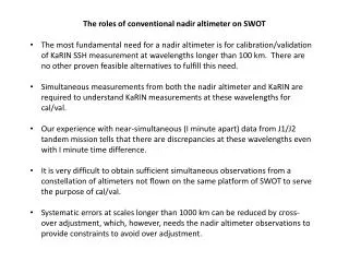
The roles of conventional nadir altimeter on SWOT. The most fundamental need for a nadir altimeter is for calibration/validation of KaRIN SSH measurement at wavelengths longer than 100 km. There are no other proven feasible alternatives to fulfill this need.

E N D
The roles of conventional nadir altimeter on SWOT • The most fundamental need for a nadir altimeter is for calibration/validation of KaRIN SSH measurement at wavelengths longer than 100 km. There are no other proven feasible alternatives to fulfill this need. • Simultaneous measurements from both the nadir altimeter and KaRIN are required to understand KaRIN measurements at these wavelengths for cal/val. • Our experience with near-simultaneous (I minute apart) data from J1/J2 tandem mission tells that there are discrepancies at these wavelengths even with I minute time difference. • It is very difficult to obtain sufficient simultaneous observations from a constellation of altimeters not flown on the same platform of SWOT to serve the purpose of cal/val. • Systematic errors at scales longer than 1000 km can be reduced by cross-over adjustment, which, however, needs the nadir altimeter observations to provide constraints to avoid over adjustment.
SSH spectra from Jason-1 and Jason-2 along pass 132 J1-J2 difference over 1 minute
SWOT Calval Approach At scales > 120 km Cal/val by nadir altimeter Cal/val by AirSWOT ~ 120 km
The roles of conventional nadir altimeter on SWOT (cont’d) • The nadir measurement thus provides a one-dimensional baseline reference for interpreting and utilization of the two-dimensional data. • Without the nadir altimeter, we would be in a situation like missing tide gauges for calibrating/validating conventional altimeter observations. • The point-wise tide gauge measurement was the only reference information we had for sea surface height to understand the one-dimensional profile measurement from conventional altimeters when they were first flown. • Likewise, the one-dimensional profiles of SSH is the only reference information we have to understand the two-dimensional KaRIN measurement for calibration/validation at wavelengths larger than 100 km. AirSWOT is needed for shorter wavelengths, but it cannot meet the needs at long wavelengths.
The roles of conventional nadir altimeter on SWOT (cont’d) • Without full understanding of the performance of KaRIN at all wavelengths, we will not be able to demonstrate its adequacy to serve as the next generation altimeter. • Without the nadir altimeter, we will not be able to provide a direct link of the KaRIN observations to the previous altimetry record that has been calibrated and validated with experience from over 20 years’ effort. • The nadir altimeter is also needed for calibration and validation of the SWH measurement from KaRIN. Accurate SWH is needed for making sea-state bias correction, a leading source of error in SSH measurement. • The dual-frequency nadir altimeter will provide information for the ionospheric range delay, but at Ka-band this is considered secondary effect.
Scales of Ocean Circulation Ocean Topography Sea Surface Temperature 2000 km 200 km
The dynamic linkage of the mesoscale to the basinscale and dissipation Spectral energy transfer function Energy flux from 30 km to > 1000 km Energy flux from 30 km to dissipation 30 km Capet et al. (2008)