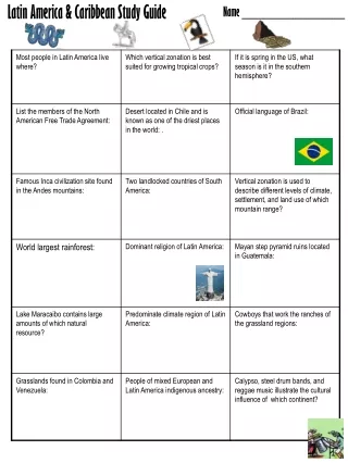
Latin America & Caribbean Study Guide: Map Identification
40 likes | 62 Vues
Test your knowledge of Latin American and Caribbean countries, capitals, and physical features with this comprehensive study guide. Identify the countries, capitals, bodies of water, and physical features on the provided maps to enhance your geographic understanding. Get ready to master your geography skills!

Latin America & Caribbean Study Guide: Map Identification
E N D
Presentation Transcript
Latin America & Caribbean Study Guide Name ________________
Identify the countries and/or capitals on the map! • ________________ • ________________ • ________________ • ________________ • ________________ • ________________ • ________________ 7
Central America Map Identification 7 1 5 6 4 2 3 • ________________ • ________________ • ________________ • ________________ • ________________ • ________________ • ________________ Identify the countries and bodies of water on the map above!
Physical Features Map Identification 6 1 5 3 2 4 • ________________ • ________________ • ________________ • ________________ • ________________ • ________________ Identify the physical features on the map above!