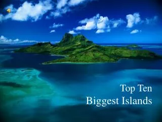
Top Ten Biggest Islands
Top Ten Biggest Islands Greenland Greenland Greenland is a member country of the Kingdom of Denmark Greenland is located between the Arctic and Atlantic Oceans, east of the Canadian Arctic Archipelago Greenland is, by area, the world's largest island that is not a continent in its own right

Top Ten Biggest Islands
E N D
Presentation Transcript
Greenland • Greenland is a member country of the Kingdom of Denmark • Greenland is located between the Arctic and Atlantic Oceans, east of the Canadian Arctic Archipelago • Greenland is, by area, the world's largest island that is not a continent in its own right • The total area of Greenland measures 2,166,086 km² (836,109 sq mi) • About 81 percent of Greenland's surface is covered by the Greenland ice sheet. • Greenland today is critically dependent on fishing and fish exports; the shrimp fishing industry is by far the largest income earner. • The name Greenland comes from Scandinavian settlers. In the Icelandic sagas, it is said that Norwegian-born Erik the Red was exiled from Iceland for murder. He, along with his extended family and thralls, set out in ships to find the land that was rumoured to be to the northwest. After settling there, he named the land Grænland ("Greenland"). • The official languages of Greenland are Greenlandic (Kalaallisut) and Danish, and most of the population speak both of the languages. • The culture of Greenland has much in common with Inuit tradition, as the majority of people are descended from Inuit. Many people still go ice-fishing and there are annual dog-sled races in which everyone with a team participates.
Scoresby Sund in East Greenland, the longest fjord in the world. An Inuit family Orca The town Qaqortoq in southwestern Greenland. Reindeer
New Guinea • New Guinea, is the world's second largest island, having become separated from the Australian mainland when the area now known as the Torres Strait flooded after the last glacial period. • New Guinea is the most linguistically diverse area in the world: it is populated by nearly a thousand different tribal groups and a near-equivalent number of separate languages. • Most societies practise agriculture, supplemented by hunting and gathering. • Biodiversity: 5 to 10% of the total species on the planet. • Probably well over 200,000 species of insect, between 11,000 to 20,000 plant species; over 650 resident bird species, including birds of paradise and bowerbirds, parrots, and cassowaries; over 400 amphibians; 455 butterfly species; marsupials and monotremes including Bondegezou, Goodfellow's Tree-kangaroo, Huon Tree-kangaroo, Long-beaked Echidna, Tenkile, Agile Wallaby, Alpine Wallaby, cuscuses and possums; and various other mammal species. • The gardens of the New Guinea Highlands are ancient, intensive permacultures, adapted to high population densities, very high rainfalls (as high as 10,000 mm/yr (400 in/yr)), earthquakes, hilly land, and occasional frost. • There is evidence that New Guinea gardeners invented crop rotation well before western Europeans. • New Guinea contains many of the world’s ecosystem types: glacial, alpine tundra, savanna, montane and lowland rainforest, mangroves, wetlands, lake and river ecosystems, seagrasses, and some of the richest coral reefs on the planet. • A central east-west mountain range dominates the geography of New Guinea, over 1600 km in total length. The western half of the island of New Guinea contains the highest mountains in Oceania • The western half of the island contains the Indonesian provinces of Papua and West Papua, while the eastern half belongs to independent country of Papua New Guinea.
Indonesia Papua New Guinea Long-beaked echidnas Dani tribesman in the Baliem Valley Matschie's Tree-kangaroo Kurulu Village War Chief at Baliem Valley Lesser Bird of Paradise
Borneo • Borneo is the third largest island in the world: 743,330 km² (287,000 square miles). • Borneo is located at the centre of Maritime Southeast Asia • Borneo is divided between Indonesia, Malaysia and Brunei • Indonesians refer to the island as "Kalimantan." • Malaysia's region of Borneo is called East Malaysia or Malaysian Borneo. • The independent nation of Brunei occupies the remainder of the island. Brunei is the wealthiest nation in the island of Borneo. • Borneo us the world’s third highest island. Its highest point is Mount Kinabalu in Sabah, Malaysia, with an elevation of 4,095 m (13,435 ft) above sea level. • Borneo has the longest river in Indonesia: Kapuas River (~1,143 km - 710 mi) • Borneo has the longest river in Malaysia: Rajang River in Sarawak (562.5 km - 349.5 mi) • Borneo is also known for its extensive cave systems. • Borneo has one of the world's longest underwater rivers in Clearwater Cave. • Borneo has the the largest cave passage in the world in Deer Cave • Borneo’s Deer Cave is a home to over three million bats and guano • There are over 30 Dayak sub-ethnic groups living in Borneo, making the population of this island one of the most varied of human social groups. • One half of the annual tropical timber acquisition of the whole world comes from Borneo • Borneo has rainforests of the following types: the high diversity mixed dipterocarp forest, the rare peat swamp forests and heath forest. • In the Kapuas River drainage system lives a venomous species of snake that can change its skin color, Kapuas mud snake • Bornean Flat-headed Frog, Barbourula kalimantanensis, found in cold, fast-flowing mountain streams, is the only known lungless frog.
Indonesia Brunei Malaysia Kapuas mud snake Bornean Orangutan habitat Lesser Short-nosed Fruit Bat Bornean Orangutan Bornean Flat-headed Frog Nepenthes villosa pitcher plant Mount Kinabalu, a major center of biodiversity in Borneo. Kayan Woman
Madagascar • The main island of Republic of Madagascar (Madagascar) is the 4th-largest island in the world • Republic of M. is an island nation in the Indian Ocean off the southeastern coast of Africa. • Madagascar is home to 5% of the world's plant and animal species, of which more than 80% are endemic to Madagascar • Madagascar's long isolation from the neighboring continents has resulted in a unique mix of plants and animals, many found nowhere else in the world • Some ecologists refer to Madagascar as the "eighth continent" • Madagascar’s unique biodiversity includes the lemur infraorder of primates, the largest mammalian carnivore on the island - fossa, three bird families and six baobab species. • Peoples' religious beliefs revolve around indigenous beliefs 52%, Christian 41%, Muslim 7%. • Madagascar’s official languages are French and Malagasy. • Madagascar’s terrain has a narrow coastal plain with a high plateau and mountains in the center. • Madagascar’s climate is tropical along the coast, temperate inland, and arid in the south. • On Madagascar there are two seasons: a hot, rainy season from November to April, and a cooler, dry season from May to October. • South-eastern trade winds predominate, and the island occasionally experiences cyclones. • Madagascar's varied fauna and flora are endangered by human activity, as a third of its native vegetation has disappeared since the 1970s, and only 18% remains intact • Agriculture, including fishing and forestry, is a mainstay of the economy.
Giant Coua Fossa Black-and-white Ruffed Lemur Baobab Antananarivo (capital)
Baffin Island • Baffin Island is the largest island in Canada and the fifth largest island in the world • Baffin Island covers an area of 507,451 km² (195,928 sq mi). • Baffin Island is named after British explorer William Baffin. • Archeological evidence on the island indicate contact with Europeans ~1000ad – 100 years before Vikings arrival in Greenland. • On southern coast of Baffin Island is located Iqaluit, the capital of Nunavut - the largest and newest territory of Canada • Nunavut ['our land' in Inuktitut] is both the least populated and the largest of the provinces and territories of Canada. Its inhabitants are called Nunavummiut • On Baffin island, on land, examples of year-round wildlife are barren-ground caribou, polar bear, arctic fox, arctic hare, lemming and arctic wolf. • Baffin Island is one of the major nesting destinations from the Eastern and Mid-West flyways for many species of migrating birds: canada goose, snow goose and brent goose (brant goose). Shore birds include the phalarope, various waders (commonly called sandpipers), murres including Brünnich's guillemot, and plovers. Three gull species also nest on Baffin Island: glaucous gull, herring gull and ivory gull. • Long-range travellers include the arctic tern, which migrates from Antarctica every spring. The variety of water birds that nest here include coots, loons, mallards, and many other duck species. • Harp seals, walrus, beluga, narwhals, bowhead whale visit Baffin island in summer • Baffin Island has an unusually cold climate: very long, cold winters and foggy, cloudy summers, which have helped to add to the remoteness of the island. • Snow, even heavy snow occurs at any time of the year, although is least likely in July and early Augus • Baffin Island is becoming popular amongst the BASE jumping community as a hotspot due to a wide array of tall cliffs scattered around the island.
Canada Canada Nunavut Nunavut Baffin Island coast Arctic Terns migrate to Baffin Island every spring Traditional qamutik Cape Dorset Polar Bear Arctic Fox
Sumatra • Sumatra is the sixth largest island in the world and is the largest island entirely in Indonesia, ~470,000 km² • Sumatra was known in ancient times by the Sanskrit names of Swarnadwīpa ("Island of Gold") and Swarnabhūmi ("Land of Gold"), due likely to the gold deposits • European writers in the 19th century found that the indigenous inhabitants did not have a name for the island. • Marco Polo visited the island in 1292 and Ibn Battuta visited twice during 1345-1346. • The island is the world's 5th highest island • Unique plant species include: Sumatran Pine, Rafflesia arnoldii (world's largest individual flower), Titan arum (world's tallest and largest inflorescence flower). • The species present include: Sumatran Tiger, Sumatran Orangutan, Sumatran Rhinoceros, Sumatran Elephant, Sumatran Striped Rabbit, Dhole, Dayak Fruit Bat, Malayan Tapir, Malayan Sun Bear and the Bornean Clouded Leopard. • The island includes more than 10 National Parks, including 3 which are listed as the Tropical Rainforest Heritage of Sumatra World Heritage Site—Gunung Leuser National Park, Kerinci Seblat National Park and Bukit Barisan Selatan National Park. • Sumatra is not very densely populated, It is nonetheless the fifth most populous island in the world • Sumatra is the largest producer of Indonesian coffee. • Most of Sumatra used to be covered by tropical rainforest, but economic development coupled with corruption and illegal logging has severely threatened it • The people composed of many different ethnic groups, speaking 52 different languages. Most of these groups, however, share many similar traditions and the different tongues are closely related. • Malay-speaking people dominate the eastern coast, while people in the southern and central interior speak languages related to Malay, such as the Lampung and Minangkabau people.
Indonesia Dhole_the Asiatic Wild Dog Titan arum, world’s tallest flower Minangkabau women carrying platters of food to a ceremony Rafflesia sumatra, world’s largest flower Malayan Tapir Sumatran Tiger
Honshu • Honshū is the largest island of Japan, the nation's main island • Honshū is the seventh largest island, and the second most populous island in the world after Java in Indonesia. • Honshu means literary "Main State" • The island is ~1,300 km long and ranges from 50 to 230 km wide, and its total area is 230,500 km², 61% of the total area of Japan. • Mountainous and volcanic, Honshū has frequent earthquakes • Honshū’s highest peak is the active volcano Mount Fuji at 3,776 m, which makes it the world's 7th highest island. • The climate is temperate, but there is little rain on the Pacific Ocean coast in winter, whereas the Japan seacoast is characterized by snowy weather. • The major economic activities and most of the population of Japan are in Honshu. • Along the northwestern coast by the Sea of Japan it is largely fishing and agriculture • Most of the nation's industry is located along the belt running from Tokyo along Honshū's southern coastal cities, including Kyoto, Osaka, Nagoya, Kobe, and Hiroshima. • Honshū is connected to the islands of Hokkaidō, Kyūshū and Shikoku by tunnels or bridges. • There is a great biodiversity on the Honshū: the Asiatic black bear inhabits mountainous areas; smaller carnivores include Honshū wolf, red fox, raccoon dog and Japanese marten. Marine mammals include the dugong, finless porpoise and Steller's sea lion • Grazing mammals include the sika deer, Japanese serow and wild boar. • There is also a Japanese macaque, the world's most northerly monkey. • There are over 40 amphibian species including the Japanese giant salamander, one of the world's largest amphibians.
Sumowrestlers Japan Asiatic black bear - Moon Bear Japanese macaque bathing in hot springs in Nagano Japanese giant salamander
Victoria Island • Victoria Island is the 8th largest island of the world, Canada's second largest island • Victoria Island is in Canadian Arctic Archipelago, ~ 217,291 square km (83,897 sq mi) • Victoria Island is also called Kitlineq • The western third of the island belongs to the Inuvik Region in the Northwest Territories and the remainder is part of Nunavut's Kitikmeot Region. • The island is named after Queen Victoria, the Canadian sovereign from 1867-1901. • Discovered in 1838 by Thomas Simpson, it was first explored by John Rae in 1851. • It is an island of peninsulas, having a heavily indented coastline with many inlets. • The island as a whole resembles a stylized maple leaf, the main Canadian symbol. • Island’s landscape is dominated by tundra, treeless plains, rock, and snow and ice. • Of the two settlements on the island the largest is Cambridge Bay, which lies on the south-east coast and is in Nunavut. • The island should not be confused with the smaller Victoria Island located in Amadjuak Lake on Baffin Island and the city of Victoria, British Columbia, which is on Vancouver Island in the Pacific Ocean, 2000km away. • Victoria Island is largely composed of sedimentary rock. • There is a belt of Precambrian rock on the west coast and another on the south coast, veined with copper formerly used by the COPPER INUIT. • On the banks of Victoria Island in the 20th century lived Copper Inuit, so named because of their extensive use of artifacts made from the native copper deposits • In winter Copper Inuit lived in large snow-house communities on the sea ice, moving to new areas as the local seal population was hunted out. • In spring Copper Inuit broke up in small bands moved to specific areas on the coasts, from where they travelled into the interior in search of caribou, muskoxen and fish. • Barren-ground caribou, muskox, Arctic char, lake trout and ringed seal were the primary and remain important food sources today.
Northwest Territories Canada Nunavut Ringed Seal Muskox Cambridge Bay, Nunavut Drum Dancing Barren-ground Caribou