Download
1 / 32
320 likes | 336 Vues
Explore the challenges and potential issues with Level 3 aerosol data, including differences in sensors, dataday definitions, and aggregation methods.

E N D
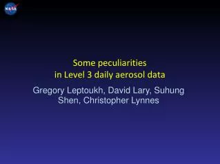
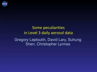
Some peculiarities in Level 3 daily aerosol data Gregory Leptoukh, David Lary, Suhung Shen, Christopher Lynnes
Why people use Level 3 products? • Level 2 data is difficult to work with because of: • Formats • Volume • Number of files • Level 3 products are mostly used by modelers, application users, climate scientists • Level 3 data are easy to use … but might lead to wrong conclusions if not being careful Gregory Leptoukh
What might go wrong with Level 3 products? • Level 3 products are the afterthoughts – science teams are usually funded to produce Level 2 • No realistic assessment of uncertainties • At best, standard deviations (mostly reflecting variability within 1 deg box), sometimes pixel count and quality histogram • Level 2 uncertainty usually doesn’t propagate to L3 • Various binning/aggregation methods lead to different results • Differences in spatial and temporal sampling in L3 from different sensors may lead to invalid comparison results But… even if Science Teams don’t like people using L3, these products are widely used, and their quality need to be addressed Gregory Leptoukh
Level 3 dataday Here we address only one aspect of potential incompatibility between Level 3 data coming from different sensors, namely, the dataday issue. Let’s compare Level 3 daily data between MODIS-Terra and MODIS-Aqua: Gregory Leptoukh
MODIS vs. MODIS ? MODIS-Terra vs. MODIS-Aqua: Map of AOD temporal correlation, 2008 Gregory Leptoukh
AOD MODIS Terra vs. Aqua in Pacific Over the dateline Away from the dateline R2 = 0.72 RMS = 0.036 R2 = 0.45 RMS = 0.05 Gregory Leptoukh
AOD Aqua MODIS vs MISR correlationmap ? AOD Aqua MODIS vs MISR correlation map for 2008 Gregory Leptoukh
MODIS vs. MISR on Terra ? MODIS-Terra vs. MISR-Terra: Map of AOD temporal correlation Gregory Leptoukh
MODIS Atmos. Data day definition Level 3 daily products are generated by binning Level 2 data belonging to one day onto a certain spatial grid according to a dataday definition. Dataday might be different for different sensors and sometimes even for the same sensor but defined by different teams. MODIS Atmospheric products (from MODIS L3 ATBD): The Daily L3 product contains statistics computed from a set of L2 MODIS granules (HDF files) that span a 24-hour (00:00:00 to 23:59:59 UTC) interval. In the case where a L2 parameter is only computed during the daytime, then only daytime files are read to compute the L3 statistics. Gregory Leptoukh
Terra Terra 00:10 21:40 Orbit Time Difference for Terra and Aqua 2009-01-06 23:30 00:30 21:55 Later in a Day 23:45 Aqua Aqua 23:20 01:45 23:00 Early in a Day 03:05 00:00 01:25 Orbit track from: http://www.ssec.wisc.edu/datacenter
Max Time diff. for Terra (calendar day) Gregory Leptoukh
Artifact Gregory Leptoukh
Data day definitions • Calendar: all granules between 00:00 – 24:00 UTC:MODIS Atmospheric products, OMI L2G • Local time (pixel-based): uses local date/time and ensures spatial continuity. TOMS, AVHRR, AIRS, OMI, MODIS Ocean, SeaWiFS More flavors: • Calendar (EqCT): 24 hours centered at the Equatorial Crossing Time at 180 deg longitude, Intermediate case • Local time (granule-based) • Local time (with ∆t = 1.6 h to eliminate multiple overlaps at high lat.) • MISR: full 14 or 15 orbits depending on a day in the 16-day cycle Gregory Leptoukh
Spatial (local time) Data Day definition • Each data set contains information for 24 hours of local time, e.g., 1:30 p.m. • The gridding starts at the dateline and progresses westward, as does the satellite. • Parts of scan lines that cross the dateline are included in the current date data set or the next, depending on which day is at the local time/day at that longitude. • For Aqua, the p.m. orbit starts at roughly 1:30 Z on the day and ends on roughly 1:30 Z of the following day. Gregory Leptoukh
AIRS local time (from L. Iredell, GSFC) Gregory Leptoukh
AIRS UTC time (from L. Iredell) Gregory Leptoukh
Max time diff. between Terra and Aqua Spatial dataday Calendar UTC (MODIS) dataday The artifact around the dateline disappears. In other areas, results are exactly the same for the (-7, 18) latitude belt. At higher latitudes, the additional restriction for one orbit time around the local time produces different results for two dataday definitions. Gregory Leptoukh
Removing the artifact in aerosol scattering angle correlation Calendar dataday Spatial dataday Artifact: difference between calendar and spatial dataday defs. Gregory Leptoukh
Removing the artifact in 16-day AOD correlation Calendar dataday Spatial dataday Artifact: difference between calendar and spatial dataday defs. Gregory Leptoukh
MODIS Cloud Top Pressure ? MODIS-Terra vs. MODIS-Aqua: Map of CTP temporal correlation, Jan 1–16, 2008 Gregory Leptoukh
MODIS Terra & Aqua vs. AIRS Cloud Top Pressure AIRS vs. MODIS Terra AIRS vs. MODIS Aqua Correlation maps for Jan 1 – 16, 2008 MODIS Aqua vs. MODIS Terra Gregory Leptoukh
Caveats and Options • Granule-based vs. L2 pixel-based: • Applying local-time approach to granules (not pixels) improves consistency between Terra and Aqua but • doesn’t remove the artifact completely • UTC begin and end time of a Level 3 day will be different for Terra and Aqua Level 3 products – it reflects the actual measurement local time • Limiting orbit overlap to +- one around the local time: • where strong diurnal or other temporal changes occur, we know that all the observations averaged occurred with in a narrow and clearly defined local time window. Gregory Leptoukh
Conclusions and recommendations • It’s the sampling… and packaging of L2 • Ability to compare daily Level 3 products from different sensors depends on the dataday definition • The calendar UTC 00-24 (MODIS) dataday definition leads to artifacts around the dateline due to ∆t between measurements reaching up to 23 hours • Spatial (local-time-pixel-based) dataday definition insures consistently small ∆t between measurements from different satellites, thus removing artifacts Gregory Leptoukh
Backups Gregory Leptoukh
Terra vs. Aqua MODIS AOD correlation: 16-day periods for 4 seasons Winter Spring Summer Fall Gregory Leptoukh
MODIS Aqua Level 3 coverage for diff. days in the 16-day cycle Start Location of Aqua Orbit Vary Daily Gregory Leptoukh
A TOMS L3 day: the ensemble of all L2 ground pixels with pixel centers that have the same local calendar date on the ground. Pixels to the east of the 180° meridian get assigned to data-day N, whereas the pixels to the west of the meridian correspond to data-day N+1. Gregory Leptoukh
Max time diff. Terra: day starts at 10:30 pm Gregory Leptoukh
Max time diff. Aqua: day starts at 1:30 am Gregory Leptoukh
Max Local time diff. for spatial DD def. with additional orbit filtering Gregory Leptoukh
MISR data day: a day in a 16-day cycle Full orbits: either 14 or 15 in a dataday Gregory Leptoukh