Download
1 / 12
120 likes | 239 Vues
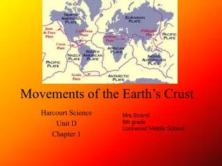
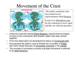
Movement of the Crust. The earth’s continents were once joined in one supercontinent called Pangaea. It took over 100 million years for the continents to move apart and they are still moving today.

E N D
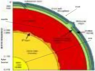
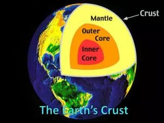
Movement of the Crust The earth’s continents were once joined in one supercontinent called Pangaea. It took over 100 million years for the continents to move apart and they are still moving today. • A German scientist named Alfred Wegener noticed that the shapes of many of the continental land masses might have been joined together. • From this observation he developed the theory of Continental drift. • He proposed the earth’s crust is divided into a number of Plates that move slowly because of Convection Currents in the mantle. • The concept of convection currents and plate movement is referred to as plate tectonics.
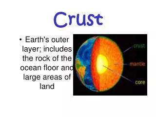
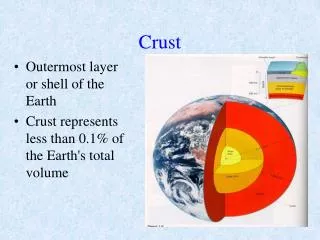
Canada’s Crust Canada is located on the northern part of the North American Plate. It is separating form the Eurasian Plate along the Mid-Atlantic Ridge. The Pacific Plate is moving northeasterly where a subduction zone is created. It is an area where one plate slides beneath another, creating volcanoes and earthquakes. http://www.jochemnet.de/fiu/OCB3043_30.html
What are Landforms? • Landforms are the topography of the land’s surface. • Topography is the natural features of the land’s surface. • A Landscape is an area’s landforms together with its cover of vegetation, water, ice, and rock. Landscapes also includes human and animal activities. Cities- urban landscape. Agricultural- rural landscapes • How do landscapes effect and influence people’s lives? • At home use your textbook to define: • Elevation______________________________________________ • Relief_________________________________________________ • Gradient_______________________________________________ • Geology_______________________________________________
Canada’s Landform Regions • Canada is so large that geographers divide it into regions to make it easier to study. • A Region is an area that is defined on the basis of the presence or absence of certain characteristics or combinations of characteristics. • Geographers classify landform regions based on a combination of characteristics. • Age of Rock • Type of Rock • Relief • Gradient • Process that has shaped the area • Canada has eight major regions
Canadian Shield • Oldest rocks in Canada 4 billion years old • Acts as foundation of Canada’s other landform regions • Thin and acidic soil called podzols. Great for coniferous tress but not agriculture • Over time this area experienced- volcanoes, plains, great mountains. Water, ice, and plate movement moved Shield materials to surrounding areas building – Appalachian Mountains, Interior Planes, Hudson Bay Lowlands • Located in Central Canada- parts of Saskatchewan, Manitoba,Ontario,Quebec.Labrador, Northwest Territories, Nunavut http://www.canadainfolink.ca/physical.htm#physio http://www.worsleyschool.net/socialarts/shield/canadianshield.html
Appalachian Mountains • Formed about 375 million years ago when the North American Plate and Eurasian Plate collided during the formation of Pangaea. • Worn down by ice & water producing rolling hills & broad valleys. • Valleys are very fertile • Forest vegetation is mixed coniferous and deciduous • Region includes most of Atlantic Canada. http://en.wikipedia.org/wiki/Image:Appalachians_NC_BLRI9242.jpg
Western Cordillera • Made up of a series of parallel mountain ranges rising over 3000m • Coast Mountains, Columbia Mountains, Rocky Mountains • Rocky Mountains- young, formed after Appalachian mountains. • Areas of valleys with good soil and deltas • Forest of the west-facing slopes are fast-growing. 200-300 year old Douglas firs may reach 100m • Includes British Columbia, Yukon Territory, part of Alberta
Innuitian Mountains • In the Far North • Steep rugged peaks rising over 2000m • Formed about 200-300 million years ago • Younger than Appalachians • Too cold for trees to survive
Arctic Lowlands • South of Innuitians – a region of upland plateau surfaces and lowland plains. • A cold, dry, poorly drained, treeless plain tundra. • Vegetation- lichens and moss • Located in Nunavut.
Interior Plains • Between Shield and Western Cordillera • Created when an inland sea receded. 500-600 million years old • Erosion carved out three prairie plains separated by escarpments. The central area is semi-desert. • The rich soil is 25cm deep and well-drained is called chernozem. Ideal for growing wheat • Covers most of Alberta, sections of Saskatchewan, Manitoba, Northwest Territories
Great Lakes- St. Lawrence Lowlands • South of Shield • Another region of plain • Lots of faulting and fractures • Flooded by a sea after the ice age- when the sea retreated it left a level base of fertile soil called brown earth. • Stretch from Ontario to Quebec.
Hudson Bay Lowlands • Within the Shield • Low area of the Shield • Accumulations of old rock 2000m deep. • Flat and poorly drained • Soil is a mix of tundra and podzols – swamp forest • Located in northern Ontario and Manitoba