Download
1 / 37
370 likes | 636 Vues
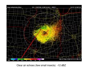
Clear air echoes (few small insects) -12 dBZ. Echoes in clear air from insects. Common is summer. Watch for echoes to expand area as sun sets and insects take off for their nocturnal travels. Echoes from birds and bats.

E N D
Echoes in clear air from insects Common is summer. Watch for echoes to expand area as sun sets and insects take off for their nocturnal travels
Echoes from birds and bats Birds take off radially from roosts in morning producing concentric rings of echo. Bats do the same at night. Migrating birds will produce small echo clusters that move across screen. Birds departing At 1114 UTC
Blocked beams (topography or buildings) Blocked beam
The bright band an enhancement of radar reflectivity at the melting level when snowflakes falling From above aggregate and develop wet surfaces. Note convective and stratiform regions of squall line. Precipitation estimates in stratiform region must be carefully examined because of bright band effects
Why there is a bright band? Recall |K2| for water is about 0.93 and for ice is about 0.176 When ice particles falling below 0oC, they start to melt, beginning from the surface. Therefore, they keep the size of the ice particle but coated with water. So the radar received power difference would be: P ice coated with water / P ice = 0.93/0.176 = 5.284 dBZ Zice coated with water = 10log Zice *5.284 = 10logZice + 10log(5.284) = dBZ Zice + 7.2 dBZ After totally melted, the ice particles becoming rain drops. The density increased from ~0.4 g/cm3 to 1 g/cm3 and the particle size decreased, so the reflectivity decreased.
The bright band appears as a ring on PPI displays where the radar beam crosses the melting level
An extreme example of bright band contamination of precipitation estimation – radar estimates 6 inches of precipitation in a winter storm on January 31, 2002!
NEXRAD (WSR-88D) Operations and Scanning Procedures
Plan-Position Indicator (PPI) Scanning procedure Echoes close to the radar are at a low elevation Echoes far from the radar are at a high elevation Data collected on a cone are projected onto a plane
WSR-88D Volume Scanning Procedures Precipitation mode scan geometry Severe weather scan geometry Saves time…fewer elevations
Clear air mode: Fewer elevations, slower antenna rotation to achieve greater sensitivity for sensing clear air turbulence, insects and clouds, light drizzle or light snowfall.
Radar reflectivity: A measure of the power scattered back to the radar from objects in the path of a radar beam. Proportional to the sum of the sixth power of the diameter of all the particles illuminated by a pulse provided the particles are much smaller than the radar wavelength.
Base reflectivity: Echo intensity at the lowest scan level (0.5o) measured in dBZ
Composite reflectivity: Maximum echo intensity at any scan level measured in dBZ
“Clear air” mode (often used for snow) Radar parameters set to increase sensitivity
Storm Total Precipitation: Measured in inches fallen after an NWS selected start time.
Storm total precipitation is the primary tool for flash flood forecasting
Vertically integrated liquid (VIL): VIL is the integration of reflectivity within a column of air. Once thought to be related to potential hail size, but not really a good predictor.
Radial velocity: Velocity component along the radar beam direction (knots)
Radial Velocity A measure of the component of the wind along the direction of the radar beam
Radial Velocity is important for detection of rotation in storms
Storm relative radial velocity: Radial velocity with the component of storm motion along the beam subtracted. Best display to see mesoscyclones, tornado vortex signatures and microburst signatures.
Radar reflectivity Radial Velocity Radar reflectivity together with Radial velocity provide means to identify potential tornadoes
NEXRAD PRODUCTS: LEVEL 2 DATA: Radar reflectivity and radial velocity at original sampling resolution. LEVEL 3 DATA: NEXRAD Information and Dissemination System (NIDS) Products Individual radars Base reflectivity, Composite reflectivity Storm total precipitation, Vertically integrated liquid Radial velocity, Storm relative radial velocity National or regional reflectivity composites
Range-Height Indicator (RHI) Scanning procedure Radar is scanned in elevation at a fixed azimuth Volume scans are accomplished by rotating slowly in azimuth while scanning rapidly in elevation
A sequence of RHI scans showing the development of precipitation in a small cumulus cloud over Florida Note ground clutter and echo from tall buildings (echo from radar side lobe)
Time-Height Display (Radar beam pointed vertically as storms move over the radar) Winter snowbands move across vertically pointing radar
“Reconstructed” RHI displays reflectivity Radial velocity Vertical cross section through a mesoscale convective system reconstructed from scans from a PPI volume from a NEXRAD
Horizontal cross sections Radar data are interpolated from cylindrical coordinates to Cartesian coordinates and displayed in Cartesian space If more than one Doppler radar scans the storm, winds can be derived using multiple-Doppler analysis techniques that we will discuss later in the course. Note location of cross section
Vertical cross sections Cartesian data can be used to construct vertical cross sections similar to the RHI If more than one Doppler radar scans the storm, vertical winds can also be derived using multiple-Doppler analysis techniques.
Radar composites: Data from PPI scans from many radars are projected onto a single image to give a map of precipitation distribution. On the display below, surface data are used to recolor the echo to show where snow and mixed precipitation are occurring. Radar data are not used to make this distinction.
Assignment #2 If air with precipitation water content of 1 g/m3, assuming mono size distribution (all hydrometeors have same size) How many raindrops would be in 1 m3 (total number density N) if all raindrops have diameter (D) of 1 mm? Calculate 10log(N*D6), units in mm6/m3. How many snowflakes would be in 1 m3 if all snowflakes have diameter of 5 mm and density in 0.3 g/cm3? Calculate 10log(N*D6), units in mm6/m3. How many hails would be in 1 m3 if all hails have diameter of 10 mm and density in 0.9g/cm3? Calculate 10log(N*D6), units in mm6/m3.