Download
1 / 40
400 likes | 433 Vues
Learn about Earth's water cycle, runoff, infiltration, soil characteristics, stream dynamics, watersheds, stream loads, carrying capacity, and more.

E N D
Surface Water Movement • Earth’s water supply is recycled in a continuous process called the water cycle. • The overall process is one of repeated evaporation and condensation powered by the Sun’s energy.
Once water reaches Earth’s surface it can evaporate into the atmosphere, soak into the ground, or flow down slopes on Earth’s surface. • Runoff is water flowing downslope along Earth’s surface. • Runoff may reach a stream, river, or lake, may evaporate or seep into the ground. • Water that seeps into Earth’s surface becomes groundwater.
For water to enter the ground, there must be large enough pores to accommodate the water’s volume. • If the pores already contain water or the soil has few pores, the newly fallen precipitation will accumulate on the surface or run downhill.
Soils that contain vegetation allow more water to enter the ground than soils with no vegetation.
Light, gentle precipitation infiltrates the dry ground. • During heavy precipitation, water falls too quickly to soak into the ground and becomes runoff. • A gentle, long-lasting rainfall is more beneficial to plants and causes less erosion by runoff than a torrential downpour.
Humus creates pores in the soil, thereby increasing a soil’s ability to retain water. • Soil with a lot of coarse particles has relatively large pores between its particles that allow water to enter and pass through the soil quickly. • Soil with a lot of fine particles clumps together and has few or no spaces between the particles. • Small pores restrict both the amount of water that can enter the ground and the ease of movement of water through the soil.
Water from precipitation falling on slopes flows to areas of lower elevation. • The steeper the slope, the faster the water flows. • There is also greater potential for erosion on steep slopes. • In areas with steep slopes, little water seeps into the ground before it runs off.
A stream is a channel with permanent water flow. • All streams flow downslope to lower elevations. • Tributaries are streams that flow into other streams, increasing the size of the stream it is joining. • A large stream is called a river, and all its tributaries make up a stream, or river system. • Small streams are called brooks and creeks.
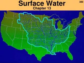
A watershed is all of the land area whose water drains into a stream system. • A divide is a high land area that separates one watershed from another. • Each tributary in a stream system has its own watershed and divides.
A stream’s load includes all the materials that the water in a stream carries. • A stream load includes the living and nonliving components. • A stream carries its load in solution, suspension, or as bed load.
Material is carried in solution after it becomes dissolved in a stream’s water. • The amount of dissolved material that water carries is often expressed in parts per million, or ppm. • The total concentration of materials in solution in streams averages 115–120 ppm. • Measuring the amount of material in solution helps scientists monitor water quality.
All particles small enough to be held up by the turbulence of a stream’s moving water are carried in suspension. • Particles that are carried in suspension are part of a stream’s suspended load. • The amount of material in suspension varies with the volume and velocity of the stream water.
A stream’s bed load consists of sand, pebbles, and cobbles that the stream’s water can roll or push along the bed of the stream. • Abrasion occurs as the particles grind against one another or against the solid rock of the streambed. • This action contributes to the physical weathering of the stream’s bottom and sides and the bed load itself.
A stream’s carrying capacity is its ability to transport material. • Carrying capacity depends on the velocity and the amount of water moving in the stream. • A stream’s water moves more quickly where there is less friction and greater slope. • The total volume of moving water also affects a stream’s carrying capacity.
Discharge is the measure of the volume of stream water that flows over a particular location within a given period of time, commonly expressed in cubic meters per second (m3/s). • The following formula is used to calculate the discharge of a stream: discharge = width X depth X velocity (m3/s) (m)(m) (m/s)
As a stream’s discharge increases, the stream’s carrying capacity increases. • A stream’s ability to erode the land increases when water velocity and volume increase. • A streambed can widen and deepen increasing the stream slope and adding to the stream’s carrying capacity.
A flood occurs when more water pours into a stream than the banks of the stream channel can hold causing water to spill onto the adjacent land. • A stream’s floodplain is the broad, flat area that extends out from a stream’s bank and is covered by excess water during times of flooding.
As floodwater recedes and its volume and speed decrease, the water drops its sediment load onto the stream’s floodplain. • Floodplains develop highly fertile soils as more sediment is deposited with each subsequent flood.
Flood stage is the level at which a stream overflows its banks and the crest of the stream is the maximum height.
Flooding may occur over localized, small areas or across large regions. • An upstream flood is the flooding of a small area. • Sudden rainstorms that drop large amounts of rain within a short period of time cause upstream floods. • Downstream floods result from heavy accumulations of excess water from large regional drainage systems. • Downstream floods occur during or after long-lasting, intense storms or spring thaws of large snowpacks.
Government agencies including the National Weather Service and The U.S. Geological Survey (USGS) monitor potential flood conditions.
The first condition for stream formation is an adequate supply of water. • The region where water first accumulates to supply a stream is called the headwaters. • A stream channel forms as the moving water carves a pathway into the sediment or rock.
Stream banks, the ground bordering the stream on each side, hold the moving water within the confines of the stream channel. • Headward erosion is the process by which small streams erode away the rock or soil at the head of the stream.
Sometimes, a stream erodes its way through the high area separating two drainage basins, joins another stream, and then draws away its water. • This process is called stream capture, or stream piracy.
As a stream erodes its path through the sediment or rock, a V-shaped channel develops. • V-shaped channels have steep sides and can form canyons. • Over time, a V-shaped valley will be eroded into a broader valley that has gentle slopes.
A stream’s slope decreases as it nears its base level and the channel gets wider. • A meander is a bend or curve in a stream channel caused by moving water.
Water in the straight parts of a stream flows at different velocities, depending on the location of the water in the channel. • In a straight part water in the center is flowing at the fastest. • Water along the bottom and sides of the channel flows more slowly because of friction as it moves against the land.
The water moving along the outside of a meander curve experiences the greatest rate of flow within the meander. • The water that flows along this outside part of the curve continues to erode away the sides of the streambed, making the meander larger. • Along the inside of the meander, the water moves more slowly and deposition is dominant.
It is common for a stream to cut off a meander and once again flow along a straighter path. • The cut off meander becomes an oxbow lake. • As a stream approaches its end point the gradient flattens out and its channel becomes very wide. • The mouth is the area of the stream that leads into the ocean or another large body of water.
A stream’s speed slows down and its sediment load drops when its gradient abruptly decreases. • In dry regions, a stream’s gradient may suddenly decrease causing the stream to drop its sediment as a fan-shaped deposit called an alluvial fan. • Alluvial fans are sloping features formed at the bases of slopes and composed mostly of sand and gravel.
Streams also lose velocity and the ability to carry sediment when they join larger bodies of water. • A delta is the triangular deposit consisting of silt and clay particles that forms where a stream enters a large body of water.
If the land over which the stream is flowing uplifts or if the base level lowers, the stream undergoes rejuvenation. • During rejuvenation, a stream resumes the process of downcutting toward its base level. • If rejuvenation occurs in an area where there are meanders, deep sided canyons are formed.
A lake is a depression in the surface materials of a landscape that collects and holds water. • Reservoirs are lakes made for the primary purpose of storing water for a community’s use.
Natural lakes form in different ways in surface depressions and in low areas. • Oxbow lakes form when streams cut off meanders and leave isolated channels of water. • Lakes can form when stream flow becomes blocked by sediment from landslides.
Cirque lakes form when cirques carved high in the mountains by valley glaciers fill with water. • Kettle lakes formed when blocks of ice left on the outwash plain ahead of melting glaciers eventually melted and left depressions that filled with water. • Some lakes are formed when the ceilings of caves collapse.
The amount of dissolved oxygen helps determine the quality of lake water and its ability to support life. • Eutrophication is the process by which lakes become rich in nutrients resulting in a change in the kinds of organisms in the lake. • Eutrophication speeds up with the addition of fertilizers, that contain nitrogen and phosphorus.
A wetland is a land area that is covered with water for a large part of the year. • Bogs receive their water from precipitation soil tends to be rich in Sphagnum (peat moss).
Wetlands serve as a filtering system that traps pollutants, sediments, and pathogenic bacteria contained in water sources. • Wetlands also provide vital habitats for migratory waterbirds and homes for an abundance of other wildlife. • From the late 1700s to the mid 1980s, the continental United States lost 50 percent of its wetlands.