Coastal Health Assessment of St. Thomas Beaches in the U.S. Virgin Islands
This report evaluates various beaches in St. Thomas, U.S. Virgin Islands, including Lindquist Beach, Magens Beach, and Brewers Bay. It highlights the ecological health of these beaches, the impact of human activities, and the natural features that influence their condition. Well-vegetated dunes at Lindquist Beach demonstrate healthy shorelines, while Magens Beach benefits from its sheltered position. The study also discusses erosion issues at Lindbergh Beach and the effects of coastal development on beach sustainability.

Coastal Health Assessment of St. Thomas Beaches in the U.S. Virgin Islands
E N D
Presentation Transcript
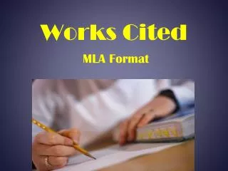
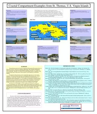
Lindquist Beach -Lindquist beach is a good example of a healthy beach. -Note the establishment of well vegetated dunes and other small upland areas. Magens Beach -The beach here is lower energy compared to surrounding beaches because it is well protected by the deeply concave, western facing embayment. -Wide dry beach widths provide an excellent place for sunbathing and other recreational activities. Study Sites Magens Beach Lindquist Beach Bolongo Beach -This beach is in fairly good condition. However, small boats and docks tend to disrupt sediment transport along the shoreline. -Beach rock and small reefs aid in decreasing wave energy. Revetment placed in front of development is a sign of an erosion problem. Brewers Bay -An excellent example of natural beaches that have suffered minimal human impacts. -The elevation of surrounding areas provides adequate protection against storm surges from hurricanes. Brewers Bay Lindbergh Beach Limetree Beach Morningstar Beach Bolongo Beach Lindbergh Beach -This part of the embayment is suffering from a considerable amount of erosion. Note rock revetment to protect the road. -The coarse sediment and slope of this beach reflect a fairly energetic environment. Morningstar Beach -A small rocky headland offers little rotection once a beach becomes heavily developed. -Once structures are placed along the beach within reach of the tides, considerable loss of beach is inevitable. Limetree Beach -A small revetment provides a clue that the horeline here is fairly dynamic and periodically changes throughout the year. -Rocky headlands provide some protection for this small pocket beach. Coastal Compartment Examples from St. Thomas, U.S. Virgin Islands The St. Thomas work was done as part of a week-long short course on coastal/reef/groundwater resources and problems taught for the University of the Virgin Islands and the Virgin Islands Water Resources Research Institute. As part of that course, a reconaissance-level investigation of coastal compartments of St. Thomas was done. In addition, a geoindicators assessment gave a quick indication of shoreline change based on geomorphic parameters. For more information on St. Thomas and the short course, visit http://www.westga.edu/~dbush/USVI2001. REFERENCES CITED Berger, A.R., 1996, The Geoindicator Concept and Its Application: An Introduction. In Berger, A.R. and Iams, W.J., (eds.), Geoindicators: Assessing Rapid Environmental Changes in Earth Systems. Rotterdam: A. A. Balkema, p. 1-14. Berger, A.R., 1997, Assessing Rapid Environmental Changes Using Geoindicators. Environmental Geology, 32(1), p. 36-44. Bush, D. M., Webb, R. M.T., González Liboy, José, Hyman, Lisbeth, and Neal, W.J., 1995. Living With the Puerto Rico Shore, Durham, NC and London: Duke University Press, 193 p. Bush, D.M., Neal, W.J., Young, R.S., and Pilkey, O.H., 1999, Utilization of Geoindicators for Rapid Assessment of Coastal-hazard Risk and Mitigation. Ocean and Coastal Management, 42(8), p. 647-670. Bush, D.M., Richmond, B.R. and Neal, W.J. 2001. Coastal Zone Hazard Maps: Eastern Puerto Rico. Environmental Geosciences, 8(1), p. 38-60. Cambers, Gillian, 1998, Planning for Coastline Change 2a: Coastal Development Setback Guidelines in Nevis. COSALC, University of Puerto Rico Sea Grant College Program, Mayaguez, PR, 39p. Cambers, Gillian, 1997, Beach Changes in the Eastern Caribbean Islands: Hurricane Impacts and Implications for Climate Change. In Leatherman, S.P., (ed.), Island States at Risk: Global Climate Change, Development and Population. Journal of Coastal Research, Special Issue 24, p. 29-47. Cambers, Gillian, 1996, Towards Integrated Coastal Zone Management in Small Island States. In Maul, G.A., (ed.), Small Islands: Marine Science and Sustainable Development. Washington DC: American Geophysical Union, p. 323- 328. Clark, J.R., 1996, Coastal Zone Management Handbook. Boca Raton FL: CRC Lewis Publishers, 694p. Leatherman, S.P., (ed.), 1997, Island States at Risk: Global Climate Change, Development and Population. Journal of Coastal Research, Special Issue 24, 242p. Maul, G.A., (ed.), 1996, Small Islands: Marine Science and Sustainable Development. Washington DC: American Geophysical Union, 467p. McElroy, J.L. and Albuquerque, K de, 1998, Tourism Penetration Index in Small Caribbean Islands. Annals of Tourism Research, 25(1), p. 145-168. Nicholls, R.J. and Leatherman, S.P., (eds.), 1995, Potential Impacts of Sea-Level Rise on Developing Countries. Journal of Coastal Research, Special Issue 14, 323p. Young, R.S., Bush, D.M., Pilkey, O.H., and Neal, W.J., 1996, An Inexpensive Approach to the Qualitative Evaluation of the Shoreline Change Geoindicator and Associated Risk from Coastal Hazards. In Berger, A.R., (ed.), Geological Indicators of Rapid Environmental Change. Rotterdam: A. A. Balkema, p. 193-206. SUMMARY This preliminary proposed Coastal Compartment Management Plan approach has not been tested, however, the basis for defining compartments and evaluating compartments using the geoindicators method has been applied in Antigua, Puerto Rico, St. Thomas, St. Croix, and Roatan. The idea of a CCMP first developed during studies of sediments on the northern insular shelf of Puerto Rico and subsequent coastal-hazard risk vulnerability mapping. The purpose of this proposed coastal-compartment approach is to foster greater attention to the natural setting as the basis for management plans and decisions. Coastal variability or coastal type is currently taken into consideration, but often in terms of determining a single management tool. For example, recommended development setback guidelines for Nevis were based on coastal type (cliff, low rocky shore, beach) and beach erosion rates plus projected sea-level rise (Cambers, 1998). In addition to coastal types, natural/critical habitats, recreational uses, economic development and tourism, port factilities, plus reefs or other protective barriers are also considered in the CCMP. The main goal of the CCMP is to aid in simplifying management strategies by dividing up the shoreline into small segments which can be quickly assessed, prioritized, and managed based on available resources. Once compartments are delineated and assessed, they can be prioritized for management plans specific to each compartment. The CCMP philosophy places the onus of management decisions on the community that is going to benefit. ACKNOWLEDGEMENTS The idea for the Coastal Compartment Management Plan, and subsequent details and approach were refined during several hurricane impact studies supported over the years by the Federal Emergency Mangement Agency, the Natural Hazards Research and Applications Information Center, the U.S. Geological Survey, the National Science Foundation, and the Public Entity Risk Institute. In additional the State University of West Georgia, Western Carolina University, and Grand Valley State University each provided faculty research grants and/or other assistance to make this work possible. We are grateful for the generous support of all of these agencies and universities. Special thanks are due to Chester Jackson for assistance with the field work in St. Thomas and Puerto Rico, and for the St. Thomas photographs.