Download
1 / 20
200 likes | 408 Vues
Presented By: David Franc NOAA’s National Weather Service. Ground Based Meteorological Radars. September 2005. Operational Functions. Primary use is for operational meteorology, research and navigation. Important functions include: Severe storm tracking Flash Flood Warnings

E N D
Presented By: David Franc NOAA’s National Weather Service Ground BasedMeteorological Radars September 2005
Operational Functions • Primary use is for operational meteorology, research and navigation. Important functions include: • Severe storm tracking • Flash Flood Warnings • Air Traffic Safety
How do Meteorological Radars impact your life? • Routine weather forecasts • Severe weather and flash flood warnings • Aviation and maritime safety • Personal travel safety • Safe, timely transport of personal and commercial goods • Agriculture – your source of food • Power management • Highway management • Water management
Spectrum Allocations • Meteorological radars operate under the radiolocation and radionavigation services • Three bands identified for ground-based meteorological radars in the Radio Regulations • 2 700-2 900 MHz: Relevant Footnote 5.423 • 5 600-5 650 MHz: Relevant Footnote 5.452 • 9 300-9 500 MHz: Relevant Footnote 5.475
Frequency Band Selection • Radar range inversely proportional to frequency • Increased propagation loss for higher frequency bands • Precipitation absorption • Unambiguous range-velocity product • Other considerations • Spatial resolution
Propagation and Absorption • Propagation losses increase as frequency increases • Radar propagation path is two way • Many meteorological radars used for precipitation estimation • Cannot estimate rainfall in a storm if radar returns are absorbed by the storm
Unambiguous Range-Velocity • Doppler radar performance limited by the unambiguous range/velocity product Where, Ra = Unambiguous range Va = Unambiguous velocity As frequency increases, the maximum range or maximum observable velocity, or both must decrease. Technology to overcome range/velocity limitations degrade radar performance in other ways
Comparison of the Bands General Trends: System Cost: Highest- 2700-2900 MHz Lowest- 9300-9500 MHz System Complexity: Highest-2700-2900 MHz Lowest- 9300-9500 MHz Operating Range: ~450 km- 2700-2900 MHz ~200 km- 5600-5650 MHz >75 km- 9300-9500 MHz Severe Weather Performance Rating: Highest - 2700-2900 MHz Lowest - 9300-9500 MHz
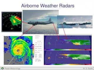
Meteorological Radar Products • Radar generates three base data products: • Reflectivity • Mean Radial Velocity • Spectrum Width • Base products used to produce many high level products • Examples: rainfall estimates, wind shear detection, precipitation type, aircraft icing levels…
Sharing Study Considerations • Antenna movement • Antenna pattern • Protection criteria
Antenna Movement • Antenna moves to conduct a volume scan • Antenna will step through 2 to 10 elevations • Full 360 rotation performed at each elevation • May take 10 to 15 minutes to complete entire volume scan • Dynamic simulations require much longer run times in comparison to radars rotating at a constant elevation
Antenna Patterns • Pencil beam antenna pattern • Standard ITU-R parabolic antenna patterns not applicable • ITU-R patterns too broad for pencil beam • Typically result in over estimation of interference
Protection Criteria • Protection criteria published in 3 ITU-R recommendations • 2700-2900 MHz: M.1464 • 5600-5650 MHz: M.1638 • 9300-9500 MHz: M.[8B.8-10GHZ] • Criteria in M.1464 based on testing • Criteria in M.1638 and M.[8B.8-10GHZ] currently based on basic radar theory
Protection Criteria (continued) • Testing to determine criteria (refer to Annex 3 of M.1464) • Inject interference signal at known level relative to radar noise floor • Alternate interference free and interference- injected volume scans • Collect the radar base data products - compare interference and interference free base data of each resolution cell • Lowest interference level causing out of spec. base data results is protection criteria.
Future Trends • Sensitivity • Met radars currently process returns 3 to 6 dB below noise floor • Minimum signal to interference ratio (Smin/I) • Lower memory and processing costs - radars processing signals further below noise floor • Lower usable S/N leads to lower required I/N • Phased array antennas • Allow other volume scan strategies • Can periodically return to an area of concern in atmosphere during a volume scan
Future Trends (continued) • Radar networks integrating radars using two or more frequency bands • Low frequency- good storm performance at long range • Higher frequency- gap filler radars where short range (mitigating cone of silence) or high resolution performance is needed • Increased automation • Mode selection • Severe weather signature detection
Conclusion • Meteorological radars operate differently and produce different products than other radar types • The differences need to be considered when conducting sharing studies • Limitations of physics dictate frequency band use • Meteorological radars with higher sensitivity – lead to greater interference sensitivity