Technology
Department of Earth and Environmental Sciences Contact: Tom Argles t.w.argles@open.ac.uk. LOGO. Month year. Universal delivery modes for Geographic Information System (GIS) content. Multilayered maps in pdf. Movies with ‘real’ landscape data. 3D model landscapes in pdf. Technology

Technology
E N D
Presentation Transcript
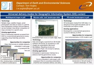
Department of Earth and Environmental Sciences Contact: Tom Argles t.w.argles@open.ac.uk LOGO Month year Universal delivery modes for Geographic Information System (GIS) content Multilayered maps in pdf Movies with ‘real’ landscape data 3D model landscapes in pdf Technology 3D landscapes created from GIS data, in a ubiquitous format (pdf) that allows user to manipulate and explore model Existing applications Developed for a second-level geoscience course for delivery on DVD Opportunities for companies Low-cost presentation of 3D models in pdf Technology Multiple maps, satellite images, aerial photographs and data as layers in a pdf file. Semi-transparent overlays and annotations can be included. User-driven comparison of maps and data for a specific area Existing applications Part of multimedia materials accessed from DVD for a second-level geoscience course, supporting virtual field trips and other activities Opportunities for companies Easy client access to multiple datasets; embedded in web page, or powerpoint file; low cost Embedded Flash movie of Cuillin ridge, Skye Technology Data and imagery exported from 3D ArcGIS software (ArcScene) as animations or still images are assembled in Microsoft MovieMaker. Resulting movies are converted to Flash (.flv) format for delivery Existing applications Embedded in web browser interface for a distance-learning geoscience course Opportunities for companies Can be embedded in web pages, pdfs, powerpoint files for seamless presentation; small file sizes facilitates delivery and utility A series of screenshots of a multilayered pdf file, showing layers combined in different combinations Screenshot of 3D pdf model of volcanic landscape, N. Chile