Download
1 / 23
230 likes | 240 Vues
Monroe County GIS provides a comprehensive web application for planning, emergency management, health department, highway department, and other government departments to effectively manage and analyze data. The application offers various tools for parcel selection, detailed reports, CAMA data, and sales disclosure information. It is hosted by Monroe County and requires plug-ins for certain browsers.

E N D
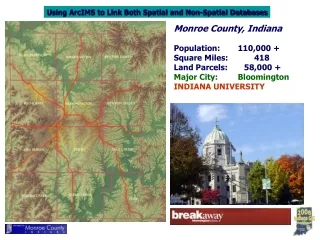
Monroe County, Indiana Population: 110,000 + Square Miles: 418 Land Parcels: 58,000 + Major City: Bloomington INDIANA UNIVERSITY
Monroe County GIS Background GIS since the late 1980’s SOFTWARE PLATFORMS AutoCad Genamap AutoCad Map/ESRI ESRI
GIS Web Applications: AutoDeskESRI MapGuideArcIMS Plug-in requiredHosted by Monroe County Hosted off site by vendor Functions on all browsers (Monroe Co has many MAC users) NOT easily ported to other browsers (MAC, Mozilla Firefox, etc) Data in SDE GeoDatabase, constantly updated Data transferred off site and updated weekly
HEALTH SURVEYOR TECHNICAL SERV EMERGENCY MGMT AUDITOR HIGHWAY ASSESSOR PLANNING Monroe County GIS Integration HEALTH DEPT EMERGENCY MANAGEMENT HIGHWAY DEPT Trimble GeoXT gis.co.monroe.in.us Microsoft SQL Server
Monroe County Government gis.co.monroe.in.us http://www.co.monroe.in.us