Download

1 / 13
130 likes | 135 Vues
This article provides information on the New Vertical Datum project, including its rationale, components, estimated outcome, and recent updates on the GRAV-D processing. It highlights the goal of increasing the accuracy and utility of the vertical datum by referencing a global geopotential surface accessible through space-based measurement systems.

E N D
New Vertical Datum: plans, status, GRAV-D update FGCS San Diego, CA. July 11, 2011 Mark C. Eckl NGS Chief of Observation and Analysis Division, New Vertical Datum Project Manager
NEW VERTICAL DATUM(Topics) • Rationale for the New Vertical Datum • Components of the Project Plan • Estimated Outcome
NEW VERTICAL DATUM(Rationale) • To be consistent with the shift in the geometric reference frame/ellipsoid (2022) • Improvement in our technical abilities in reference surface realization (geopotential gravimetric reference surface - 1cm accuracy of geoid (GNSS/GRAV-D)) • The new geopotential reference surface will be aligned with the geometric reference frame/ellipsoid (i.e., no hybrid geoid) • A move away from differentially leveled passive control as the defining mechanism of the reference surface
NEW VERTICAL DATUM(Rationale) • The technology to make accurate vertical heights measurements with GNSS technology • To provide vertical access to formerly prohibitive places • To allow monitoring of physical or geophysical datum deformation
NEW VERTICAL DATUM(Components) • Design and adopt new geometric reference frame (Geometric Datum Project) • Realize new geometricdatum with existing passive/active control, i.e., a horizontal (geometric) adjustment • Definition of the W0 surface as the new datum reference surface • Build a gravimetric geoid with an overall accuracy of 1 cm
Determining Elevations with GNSS Improvements to the Geoid Models GRAV-D Processing Update • Alabama (‘08) and 2008 Alaska survey already delivered to Geoid team (Newton v1.1) • Next major version of aerogravity processing software is complete (Newton 1.2) • Newton 1.2 data for Alabama and Louisiana will be delivered to geoid team by early July; other surveys will quickly follow • LA/AL airborne gravity data will release publicly in next month via a web page designed to share data • Still partnering for flights; seeking a dedicated plane
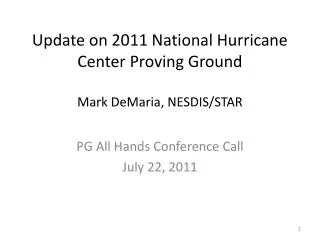
GRAV-D Survey Plans • FY 2011: • Alaska • California/Oregon coastline • Eastern Great Lakes Region • As of June 1, 13.45% of total area has been surveyed • FY2012: • Great Lakes region • Washington State • California • FY2013: • Finish Great Lakes • TBD
West Coast FY11-12 Alaska FY11 (FY11 Already Flown) FY11-13 Great Lakes Plan FY10 = Green FY11 = Blue FY12 = Orange FY13 = White
NEW VERTICAL DATUM(Components) • Studies of: • Geoid slope validations • Geoid bias • Geoid long term monitoring (i.e., change detection) • Gravity measurement systems accuracy assessments • GNSS ellipsoid absolute height measurements • GNSS differential ellipsoid height measurements
NEW VERTICAL DATUM(Components) • Prepare a forward and backward vertical datum conversion strategy - points and maps/charts (ref: NC Pilot Project) • Work with FGCS for adoption of new/updated (FGCS Vertical Working Group): • Standards of Accuracy • Specifications • Procedures, and • Guidelines • Outreach
NEW VERTICAL DATUM(Goal) Increase the accuracy and utility of the vertical datum by referencing a global geopotential surface, related to global sea-level, which is accessible through space-based measurement systems and which maintains the differential precision associated with any NGS adopted vertical datum.