Download
1 / 28
280 likes | 439 Vues
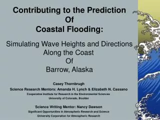
Contributing to the Prediction Of Coastal Flooding:. Simulating Wave Heights and Directions Along the Coast Of Barrow, Alaska. Casey Thornbrugh Science Research Mentors: Amanda H. Lynch & Elizabeth N. Cassano Cooperative Institute for Research in the Environmental Sciences

E N D
Contributing to the Prediction Of Coastal Flooding: Simulating Wave Heights and Directions Along the Coast Of Barrow, Alaska Casey Thornbrugh Science Research Mentors: Amanda H. Lynch & Elizabeth N. Cassano Cooperative Institute for Research in the Environmental Sciences University of Colorado, Boulder Science Writing Mentor: Nancy Dawson Significant Opportunities in Atmospheric Research and Science University Corporation for Atmospheric Research
Background • The Alaska North Slope Region • Research Problems • Methodology • Data Used • Description of SWAN wave simulations • Results • Conclusions
The Alaska North Slope Region Beaufort Sea Chukchi Sea William Manley INSTAAR 100 meter pixel size Digital Elevation Model of the Alaska North Slope
The Research Problems Coastal flooding models incorporating tidal fluctuations and storm surges, have often produced results where the simulation of coastal flooding was below the actual observed coastal flooding. There is a lack of raw data consisting of wave height measurements and wave directional data offshore or in the Barrow coastal region.
The Naval Arctic Research Lab (NARL) (Approximately 1.5 miles north of Barrow) October 1963 Photo courtesy of Grace Redding, 1963
October 1963 Flood Extent with 12 and 16 Foot Contours for Barrow, Alaska Chukchi Sea Flood map constructed by Leanne Lestak, William F. Manley, and James Maslanik, August 2003. The October 1963 flood extent was mapped by Hume and Schaulk, 1967.
Purpose • The purpose of this project is the use of the Simulation of Waves Near shore (SWAN) model to simulate wave heights and directions offshore and in the Barrow coastal region. • Incorporating the results from from the SWAN model with a storm surge model for Barrow, will allow a total flood height to be simulated and compared with past, observed coastal flooding.
Bathymetry of the Barrow Coastal Region Chukchi Sea Beaufort Sea Barrow Image provided by Leanne Lestak Cooperative Institute for Research in Environmental Science University of Colorado, Boulder Bathymetry map of the Barrow coastal region
Data • Bathymetry of the Barrow coastal region compiled with data from NOAA and NGDC • Daily and average monthly sea ice concentration data from NSIDC • Daily average wind speeds and directions for 11 historical storms from the Barrow NWS office • Hourly wind speeds and directions for the 29 July 2003 storm from the Barrow NWS office • The computational grid will represent an area 390 by 390 km over the Alaska North Slope coastline and the Chukchi/Beaufort Seas.
Bathymetry Input Grid for SWAN Image provided by Leanne Lestak Cooperative Institute for Research in Environmental Science University of Colorado, Boulder
SWAN The Simulation of Waves Near shore Model • SWANis a wave simulation model specifically • designed to simulate wave heights for • shallow coastal areas. • Input data for SWAN includes: • Wind direction and speed • Location and shape of the shoreline • Bathymetry of the coastal seafloor
SWAN The Simulation of Waves Near shore Model • SWAN is a wave simulation model specifically • designed to simulate wave heights for • shallow coastal areas. • Additional input data for SWAN included: • Sea ice edge • Prescribed boundary conditions (wave height & direction)
SWAN The Simulation of Waves Near shore Model SWANwave simulations were run for: 11 historical late summer & fall storms occurring from 1 August 1950 through 31 August 2000 A.Input of a constant wind speed and direction for each storm B. Added sea ice edge C. No prescribed boundary conditions
Results (part one) • SWAN wave simulation model simulated wave heights and directions offshore and in the Barrow coastal region • High winds from any direction produced high waves offshore. • High westerly winds produced the highest waves in the Barrow coastal region.
Results (part one) • Sea ice-edge covering greater than 50% of the sea surface moderately reduced the wave heights offshore and in the Barrow coastal region.
24 October 1998 High easterly winds Wind direction Wave direction Alaska North Slope Alaska North Slope Wave heights (cm) wave direction (degrees x 10 ^ -1) Wind speed: 17.0 m/s Wind direction: 70° (East/Northeast)
20 September 1986 Moderate southwesterly winds Wind direction Wave direction Alaska North Slope Alaska North Slope Wave heights (cm) wave direction (degrees x 10 ^ -1) Wind speed: 13.9 m/s Wind direction: 225° (Southwest) Alaska North Slope Alaska North Slope
3 October 1963 High westerly winds Wind direction Wave direction Sea ice edge Sea ice edge Alaska North Slope Alaska North Slope Wave heights (cm) wave direction (degrees x 10 ^ -1) Wind speed: 17.4 m/s Wind direction: 270° (West)
24 August 1950 Moderate easterly winds with extended sea ice-edge Wind direction Wave direction Sea ice edge Sea ice edge Alaska North Slope Alaska North Slope Wave heights (cm) wave direction (degrees x 10 ^ -1) Wind speed: 14.7 m/s Wind direction: 68° (East/Northeast)
SWAN The Simulation of Waves Near shore Model SWAN wave simulations were run for: II. 6-hourly time steps for the 29 July 2003 storm A.Input of the average wind speed and direction for every 6 hrs B. Wind data 7 PM 28 July through 7 AM 30 July (Alaska time) C. Prescribed boundary conditions D. No sea ice edge
Results (part two) • SWAN wave simulation for 29 July 2003 produced maximum offshore wave heights of 5 to 5.6 m consistent with the NWS Barrow office marine forecast of waves 5 to 6 m for this storm. • Simulation produced maximum wave heights of 4.6 m, consistent with the 4 to 5 m waves observed near shore by the NWS.
Results (part two) • Boundary conditions permitted a realistic lag time for changes in wave direction in response to changes in the wind direction.
29 July 2003 1 AM Wind direction Wave direction Alaska North Slope Alaska North Slope Wave heights (cm) wave direction (degrees x 10 ^ -1) Wind speed: 10.3 m/s Wind direction: 211° (South/Southwest) Boundary conditions: wave height = 0.8 m wave direction = 225° (Southwest)
29 July 2003 7 AM Wind direction Wave direction Alaska North Slope Alaska North Slope Wave heights (cm) wave direction (degrees x 10 ^ -1) Wind speed: 15.0 m/s Wind direction: 251° (West/Southwest) Boundary conditions: wave height = 1.8 m wave direction = 215° (Southwest)
29 July 2003 1 PM Wind direction Wave direction Alaska North Slope Alaska North Slope Wave heights (cm) wave direction (degrees x 10 ^ -1) Wind speed: 16.5 m/s Wind direction: 270° (West) Boundary conditions: wave height = 3.3 m wave direction = 245° (West/Southwest)
30 July 2003 7 AM Wind direction Wave direction Alaska North Slope Alaska North Slope Wave heights (cm) wave direction (degrees x 10 ^ -1) Wind speed: 9.1 m/s Wind direction: 289° (West/Northwest) Boundary conditions: wave height = 3.0 m wave direction = 270° (West)
Conclusions Knowing the contribution of waves to coastal flooding will improve the ability to predict the total flood heights. This information exposes areas of Barrow that are vulnerable to flooding and allows community members to develop ways to protect these areas.
Acknowledgements Science Research Mentors: Amanda H. Lynch & Elizabeth N. Cassano Cooperative Institute for Research in the Environmental Sciences University of Colorado, Boulder Leanne Lestak Science Writing Mentor: Nancy Dawson Significant Opportunities in Atmospheric Research and Science SOARS Staff & Protégés