Download
1 / 11
110 likes | 237 Vues
Learn about the GIS history at Camp Pendleton, GIS deployment in 2005, the SDSFIE data model, benefits of standards, and challenges faced in implementing and maintaining data standards. Discover key insights and examples.

E N D
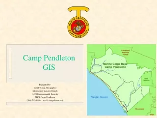
Camp PendletonGIS Presented by: David Toney, Geographer Information Systems Branch AC/S Environmental Security MCB Camp Pendleton (760) 763-1990 david.toney@usmc.mil
Camp Pendleton GIS • HISTORY:GIS came to Camp Pendleton in the mid-1980s, starting at the Public Works Office.Environmental offices quickly adopted GIS soon after that. • GIS DEPLOYMENT AT PENDLETON IN 2005: Two major areas of use of GIS:1. Environmental Security: Natural Resources, Environmental Compliance2. Public Works: Infrastructure Other stakeholders: - Fire Department: Wildland Fire Planning - Operations and Training: Deployment of forces for training activities.
Migration to SDE • 2002: Camp Pendleton decided upon an Enterprise GIS system • Required a need for a Geodatabase structure that would make sense • SDSFIE standard was adopted for GIS data • All data would be stored in an SDE server hosted by Public Works Office (all data hosted separately up to this point) • Dual effort identified: • Environmental Security and Public Works would evaluate their data separately, and then add appropriate data to SDE • Public Works effort: • ‘Dumped’ all relevant data layers into SDE • Contractor slowly reviewing data, one layer at a time, conforming to standard as necessary • Metadata to be written at a later date • Environmental Security effort: • No data ‘dumped’ into SDE • Evaluating data one layer at a time. Writing metadata, creating metadata tables as each layer is evaluated. • Loading data as it is complete and ready inclusion in the SDE
Spatial Data Standards(SDSFIE) • SDSFIE – Spatial Data Standards for Facilities, Infrastructure and Environment • An implementation of Federal Geographic Data Committee (FGDC) standards • Adherence to Executive Order 12906, signed by President Clinton in 1994, requiring Federal agencies to collect ‘geospatial data … in a manner that meets all relevant standards.’ • Multi-thematic data model • Database schema that conforms to relational database concepts but is not proprietary. • Data standards developed and maintained by CADD/GIS Technology group of the US Army Corps of Engineers: https://tsc.wes.army.mil
Why use SDSFIE standards? • Standard procedures and requirements across all installations • Conforms to Federal guidance • Facilitates data sharing among installations, through to the Headquarters level • Allows Headquarters to do data calls and regional planning with a minimum of effort – layers and attributes are common between installations • Data collection is simplified by providing contractors a common database schema at the start of a project • Standard set of attributes and domains, independent of installations
SDSFIE Data Model • Entity Sets • highest level and broadest grouping • Similar to ‘Feature Dataset’ in a Geodatabase • Examples: boundary, buildings, flora, transportation, utilities • Entity Classes • groupings of data within an Entity Set • Also similar to ‘Feature Dataset’ in a Geodatabase transportation transportation_air transportation_marine transportation_pedestrian transportation_railroad transportation_vehicle
SDSFIE Data Model • Entity Types • Single map layer • Similar to ‘Feature Class’ in a Geodatabase transportation_vehicle highway_median_area interchange_point road_bridge_area road_centerline road_feature_point road_area vehicle_parking_area • Each layer contains individual attributes specific for the needs of that layer (domains have been developed if necessary) • Attribute Tables • The table containing the attributes for a particular GIS layer
Challenges of the SDSFIE • SDSFIE is constantly evolving • Standards evolve and change once or twice a year. To stay current, you must keep up with the standards committee, and possibly update and revise your Geodatabase • Contractors • Sometimes difficult to get contractors to conform to SDSFIE standards. • Data conversion takes time • Slowly, you can migrate your data to the standards. If you have a lot of data, it can take a lot of time. • Attributes that don’t conform to standards • Must load the data into outside tables, contained within the SDE or a Personal Geodatabase
Challenges of the SDSFIE(Data Example) • Environmental Security has over 60 different layers related to endangered species management • Under the SDSFIE, most of these layers would be loaded into one table: fauna_special_species_site • Pros: Standardizes data, puts it all into one place • Cons: Different, non-SDSFIE attributes are collected for each species; requires loading additional attributes into outside tables • These additional tables are loaded into the SDE or Personal Geodatabase • Queries and layer files become important to allow for ease of access to data (i.e., user wants to see Snowy Plover nests from 1998)
Sample Attribute Table(road_centerline) • Entity Set – transportationEntity Class – transportation_vehicleEntity Type – road_centerlineAttribute Table – trvehrcl • Attributes of road_centerline (not all attributes listed):category_d – The importance of the road for transportation – Primary, Secondary, Tertiarynum_lanes – Number of normal traffic lands through the length of the centerlineuse_typ_d – Current usage status of the road – Abandoned, Active, Unknownroad_name – Common name or street name used to refer to the stretch of roadalt_name – Alternate name or second name for the roadrou1_typ_d – First route type for the road – County, Federal, Interstate, Local, Other, US Hwyrou1_name – Route number or affiliated with the first route typetunnel_d – Boolean indicating whether the segment is a tunnelleft_from – Starting point for addresses on left side of roadconst_d – Boolean indicating whether the road centerline is under constructionsuffix – End of a road name (i.e., ‘Street’ in N Oak Street)pre_type – Prefix of a road name (i.e., ‘N’ in N Oak Street)
Contact Information & Acknowledgements • Camp PendletonDavid Toney, GeographerInformation Systems Branch, AC/S Environmental Security(760) 763-1990david.toney@usmc.mil • Spatial Data Standards for Facilities, Infrastructure and EngineeringCADD/GIS Technology GroupUS Army Corps of Engineershttps://tsc.wes.army.mil • SDSFIE Training(provided source material for this presentation)Geomorph Information Systems(619) 787-7974http://www.GeomorphIS.com