Download
1 / 14
140 likes | 157 Vues
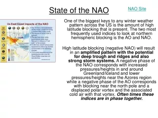
State of the NAO. NAO Site. One of the biggest keys to any winter weather pattern across the US is the amount of high latitude blocking that is present. The two most frequently used indices to look at northern hemispheric blocking is the AO and NAO.

E N D
State of the NAO NAO Site One of the biggest keys to any winter weather pattern across the US is the amount of high latitude blocking that is present. The two most frequently used indices to look at northern hemispheric blocking is the AO and NAO. High latitude blocking (negative NAO) will result in an amplified pattern with the potential for deep trough and ridges and also strong storm systems. A negative phase of the NAO corresponds with increased pressures/heights in and around Greenland/Iceland and lower pressures/heights near the Azores region while a negative phase of the AO corresponds with blocking near the north pole and a displaced polar vortex and the associated cold air with that vortex. Often times these indices are in phase together.
State of the NAO NAO Site Prediction of the NAO or the AO beyond 7-10 days is not well understood at the current time. There are different theories and forecasts out there that have had varying amounts of success. I believe there is still much to be understood from a physical perspective about predicting this process. I don’t claim to have a fool-proof way to predict either too far in the future, and in some ways the method I use is extraction and analogs of years with similar seasonal index values to see what the AO/NAO state will be.
Positive NAO • The Positive NAO index phase shows a stronger than usual subtropical high pressure center and a deeper than normal Icelandic low. • The increased pressure difference results in more and stronger winter storms crossing the Atlantic Ocean on a more northerly track. • This results in warm and wet winters in Europe and in cold and dry winters in northern Canada and Greenland • The eastern US experiences mild and wet winter conditions
Negative NAO • The negative NAO index phase shows a weak subtropical high and a weak Icelandic low. • The reduced pressure gradient results in fewer and weaker winter storms crossing on a more west-east pathway. • They bring moist air into the Mediterranean and cold air to northern Europe • The US east coast experiences more cold air outbreaks and hence snowy weather conditions. • Greenland, however, will have milder winter temperatures
Correlation of NAO and SST • Notice the anomaly pattern that accompanies winters with a –NAO. • There is an area of above normal water temperatures around and north of Newfoundland to the southern tip of Greenland and then up the Davis Strait, with an equally important below normal area south of Newfoundland to just off the NE coast of the US. • Now to think that this SST anomaly couplet is alone the cause of the NAO is naïve. It is possible it is the result of the NAO phase, more than likely it is a feedback process between the two.
State of the NAO (Prediction for 2006-07) This data (cyclic NAO) and prediction (+NAO through December) from a professional met indicates a high likelihood of a warmer than normal December and 1st half of January across the eastern U.S. 2nd half of January and 1st half of February more likely to see seasonal or below normal temperatures due to lower NAO values.
State of the NAO (General Trends in 2006) 2006 Data: Negative NAO in October 2006, Positive NAO in November 2006 2006-2007 Winter Outlook: “Positive NAO 1st half of winter, negative NAO 2nd half of winter.” Rob G. “Overall positive NAO.” Misc. Pro Met “Overall positive NAO.” Misc. Pro Met Note: Most agree that the winter NAO will be + overall but the 2nd half of winter will be less positive than the 1st half , possibly even neutral or negative.
State of the NAO (General Trends During 2006-07 El Nino Winter) • -NAO in October favors a + NAO winter • + NAO in October favors a –NAO winter • NAO state in November dictates NAO state for winter during 9 of 12 El Nino winters, including the last 6. • Of these 9, only 2 have flipped back again during the winter. • Thus, if it flips in 2006-2007 from October to November there is a 77% chance that the NAO state for the winter will be positive. • If the NAO flips from October to November it usually does not flip back and the NAO holds the November state for the winter. Note: October 2006 NAO was negative, November 2006 NAO was positive. So there was a flip. Therefore, 2006 data suggest a +NAO for winter which favors less cold and snow.
NAO Viewpoint from DT (Fall 2006) WxRisk View: While many see the SSTA set up for the Atlantic Ocean as NOT ideal for sustained intervals of the negative phase of the NAO I see some promise. Many forecasters assume that there can only be one particular manifestation of the negative phase of the NAO... which is called the “Greenland Block.”
NAO Viewpoint from DT However sometimes you can get a -NAO manifestation that shows up as a blocking pattern over the Davis Straits...or northeastern Canada or northern Québec. Indeed we saw that several times during the months of September and October. And the strong pools of very warm SSTA in and around the Davis Straits and of the coast of southeastern Canada strongly supports the idea of a westward positioned blocking pattern developing over northern Québec or the Davis Straits from time to time this winter. I do not see an" ideal“ SSTA configuration at this time although it would not take much to change the Atlantic SSTA’s into a pattern that would favor sustained -NAO.
Importance of High Latitude Blocking (-NAO) “Of course we are going to have to watch this very carefully as there is a window of opportunity for some sort of wave to develop warm front over the southeast JAN 16-18. But notice what most of the models ate doing here. Without any High latitude blocking the trough becomes very deep and the strong High pressure area drops or falls into the trough... tracking from western Canada along the east side of the Rockies all the way into Texas and Oklahoma. This is a very bad sign for significant snowstorm activity for the East Coast and especially the Northeast.This is WHY the blocking pattern over Eastern Canada is SO important because it forces the arctic High pressure systems to stay to the North and track along the US Canada border.... instead of falling into the central and Lower Plains. The High to the north keeps temperatures cold over the East coast but also provides access to ocean moisture as well as being BIG player in the set up all of ageostrophic flow when East coast Low pressure development is underway…continued…
Importance of High Latitude Blocking (-NAO) On the other hand when you do NOT have any high latitude blocking then you have got real problems in terms of getting a good winter pattern cooking. There is a tendency among weather hobbyists to really downplay the significance of high latitude blocking ....such as a sustained negative phase of the NAO. I know that there are some out there who say while you can still get big snow oin the Northeast without a Greenland block as long as you have lots of cold air. Often times the February 1995 noreaster is cited as a classic case of a good snow for the I-95 cities that and as rain and there was no high latitude blocking.Well that may be true but also proves the rule. You see the issue is not whether you can get a good snow in the Northeast without any high latitude blocking or negative phase of the NA O. You most certainly can BUT it won't stay all snow and that in my opinion is always the big issue. The February 95 system was such a rapid moving system that by the time the warm air got into the big cities of the Northeast most of precipitation had already fallen so we ended up with 85- 90% of the precip fell as snow and then the rest as drizzle or freezing drizzle. If the 2/1995 had noreaster move at a more typical speed OR if the Noreaster had closed off in the upper levels the High latitiude blocking would of been far more important. Tthe warm air would have had more time to drive inland into the I-95 cities.... meaning less snow and more rain. – DT on January 11, 2007 -