Download
1 / 32
330 likes | 674 Vues
Regional Geography Chapter 17 Different Types of Regions. What is a region?. A region is an area that has certain characteristics that set it apart and make it distinctive. A region may be defined by one or more of the following Physical Climatic Administrative Cultural Economic Urban.

E N D
What is a region? • A region is an area that has certain characteristics that set it apart and make it distinctive. • A region may be defined by one or more of the following • Physical • Climatic • Administrative • Cultural • Economic • Urban
The regions you must study are • Physical – Paris Basin (Europe) The Burren (Ireland) • Climatic – One climate – Cool Temperate Oceanic Climate • Administrative – County Councils in Ireland & Regional Authorities - Arrondissements (France) • Cultural – Northern Ireland (Ireland) Belgium (Europe) • Economic – Core Regions & Peripheral Regions • Urban – Growing Urban Regions
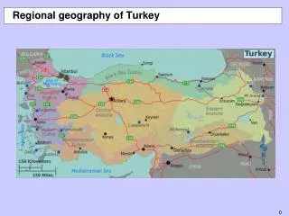
Physical Regions • North European Plain • Paris Basin • The Burren
Paris BasinEuropean Physical Region • Occupies Northern France • It is looks like a stacked saucers of rock which include limestone, chalk, sandstone and clays • The Paris Basin was affected by the earth’s movements that produced the ALPS • The Ile de France is at the centre of this basin. • There are a number of distinctive regions called pays • Beauce is one of these pays. It is covered with fertile deposits of LIMON. • Limon is believed to have been transported by the wind from the moraine deposits of Northern Europe • Brie is another pay located beside Beauce. In contrast this has a covering of heavy, damp, clay soils.
The Burren – Physical Region Ireland • Limestone Plateau that covers 360 square KM of Northern Clare • It is between a youthful to mature stage of erosion • Finest example of Karst Landscape in Ireland • Made up of beds of limestone that were laid down between 300 - 350 million years ago • Highest point is Slieve Elva at 340m above sea level • Presence of Granite Erratics suggest that ice from Connemera passed over the Burren (Glacier)
Climatic Regions • Climates can be used to distinguish one region from another • The climates of Europe are very distinctive • Each region differs in temperature and precipitation • Example – Cool Temperate Oceanic Climate. This occurs on the west margins of the continents between 40 and 60 degrees north and south of the equator • In Europe it is found in all areas that touch the Atlantic Ocean
Cool Temperate Oceanic ClimateCharacteristics • Summers are warm 15 - 17 degrees Celsius • Winters are mild 4 - 6 degrees Celsius • Temp range 11 degrees Celsius • Summer influenced by low angle of sun and frequent cloud cover • Winter influenced by warming effect of sea with the presence of NAD and frequent cloud cover • Precipitation throughout the year but with a winter maximum 600 - 3000mm • Prevailing south westerlies become warm and moist as the cross the NAD. Depressions and anticyclones move in from the west bringing changeable weather • Overall climate is described as Variable
Administrative Regions • Local Authority: Some regions can be identified as administrative regions. Counties are identified as suitable units for local administration • In Ireland 24 of the 26 counties have one county council each • Tipperary has two - north and south • Dublin has three • County Councils are democratically elected bodies • The county manager is the key administrative officer • The manager is a paid and permanent official (not elected)
What do County Councils do? • Road maintenance • planning • waste disposal • public lighting • fire services • housing accommodation for people of low income
Dublin Council Structure • The population of Dublin grew from 231,000 in the 1970’s to 600,000 by 2002 • This was due to the development of new towns in the west of the city • Three new local government authorities were created in County Dublin • Fingal - north of the Liffey • South Dublin - between Dublin Mountains and Liffey • Dun Laoghaire Rathdown • Dublin City Council continues to provide services for Dublin City
Ireland’s Regional Authorities • Ireland is divided into eight economic regions • These are used to draw comparisons in • Job creation • social patterns • population change • unemployment • per capita income • Many public bodies are organised on a regional basis which means that authorities have the opportunity to develop meaningful economic and social goals
Administrative Regions in Europe France • French departements are important units of local government in France. • They were created in 1790 during the French revolution • They are responsible for LOCAL SERVICES. • A commissioner represents the national government in each departement • Each departement is subdivided into arrondissements • These arrondissements are administered by sub prefects (I.e. county manager) • The smallest unit of local government is the Commune - totalling 36,000 - (like local parish in Ireland)
Regions associated with language • The Gaeltacht regions of Ireland • The Gaeltacht areas are mainly in the west of Ireland • The percentage of people who use Irish as their first language has been in decline for many years. • Beginning of 19th Century 2 million Irish Speakers (using Irish as first language) today around 61,000 who are residents of the Gaeltacht use Irish as first language • Emigration has been the scourge of the Gaeltacht - poverty remoteness, poor infrastructure a poor resources have led to people leaving these Irish speaking regions
Gaeltacht area boundaries have changed over time • The influence of the English language has had a major effect on the use of Irish as a first language in the Gaeltacht regions. • The influence of media - TV, Radio and Music has encouraged a greater use of English in these Regions • Irish speakers constitute 76.3% of the total population of the Gaeltacht regions. • The 1996 census found that 19,000 of Gaeltacht residents were non Irish Speaking. • This census also showed that 50.9% of 3-4 yr old children use Irish as first language. This means that one in two children use Irish as their first language and this will have major implications for the survival of the language.
Multi-lingual Regions • Language differences highlight the existence of different cultural groups • The relationship between these groups can be tense as can be seen in Belgium • Three languages are spoken in Belgium • Flemish (Dutch) - Flanders - 55% of population - North • French - Wallonia - 30% of population - South • German - Upen & Malmedy - 10% • The relationship between the two key groups the Flemish and the Walloons has been uneasy • Until 1960’s Wallonia was the prosperous part of Belgium due to deposits of Coal and Iron Ore - after this these industries went into decline as deposits ran out - the region went into decline • At the same time the Flanders region began to develop a strong economic base with new industries such as chemical industries, car assembly and electonics
Multi-lingual Regions • At the same time the Flanders region began to develop a strong economic base with new industries such as chemical industries, car assembly and electronics • So great was the tension between these two groups that frequent clashes occurred between 1950 & 1990 • In order to calm linguistic tensions the government made the three languages - Dutch, French and German official languages of Belgium • Brussels became a bilingual city • Each region was granted cultural autonomy in 1971
The Islamic World • Add your own points here
Socio-Economic Regions • Economic Development is not uniform in time and space • Some regions are considerably wealthier than others • Differences in levels of economic development can be used to identify regions • Dublin Region - Core Region • Border/Midlands/West regions - Less developed Regions - BMW Region - Peripheral Region • Many regions that were once prosperous have now gone into decline - “Regions of industrial decline”
Core Regions • Wealthy population • High population densities and inward migration from peripheral regions • Plenty of natural resources • Plenty of inward investment • Strong manufacturing and service centres
Peripheral Regions • Higher dependence on primary economic activities - fishing forestry farming • Low inward investment - few companies set up in these regions • Poorer infrastructure - roads and rail • Outward migration - people moving out of these regions • In Western Europe peripheral regions are found along the margins of the continent - away from the core regions
BMW Region • Physical Landscape • Mountainous • Soils of the lowlands are heavy and leached • Agricultural economy based on Cattle and Sheep farming which is less profitable than Arable. • Much more dependence on Primary Economic Activities than there is in the south or east.
The BMW is far away from the EU –far way from political power and influence.
The National Development Plan2000-2006 • BMW Region requires more financial investment than the rest of the country • The investment will be greater per capita in the BMW region. • This spending will go to • Road and rail infrastructure • Rural development projects • Tourism, agriculture, seafood sector and rural enterprise • This plan is to ensure that half of all new jobs from new projects will be in the BMW.
Less developed region – EuropeThe Massif Central • Distinctive geographic region composed of granite and other crystalline rocks • Average altitude is 1000m. • Climatically the region is transitional – it experiences aspects of Maritime Climate (rainfall) while Continental Climate brings the extremes of temperature (especially in the winter). • Due to the lack of infrastructure and services this region depends on agriculture – especially beef cattle and sheep.
Manufacturing in this region is confined to urban regions. Clermont-Ferrand is home to the giant tyre maker Michelin,which employs half of the manufacturing employees of the region. • This region does not attract investors due to its remoteness. This is further affected by the lack of TGV service. • This region suffers greatly from regional migration. This has resulted in an aging population. • Tourism is the main economic hope for the region.
Regions of industrial decline • Life cycle of industries – growth, maturity – decline. • Major coal producing regions • South Wales • Franco-Belgian Coalfield • Ruhr Valley - Germany • Heyday of these regions lasted until the middle of the 20th C
Decline in the later 20th C • By 1960s these traditional regions of manufacturing were experiencing an economic crisis. The reasons were • Best coal seams exhausted • Poland had become the low cost producer of coal • Steel industry which was anchored to coalfield sites was also going into decline. Steel plants in regions such as the Sambre Meuse were outdated and uncompetitive. • Government were tired of propping up the steel industry with subsidies funded by the tax payer. • In the 1960s & 1970s thousands of coalminers and steel workers lost their jobs. • The steel industry was rationalised and new ultra modern steel mills were built in their place. - These required less workers and were more efficient in terms of production.
Decline in the later 20th C • Geographical inertia helped to keep the steel industry alive i.e. companies that should have moved when the coal mines and steel plant closed didn’t and remained helping industry to survive. • The European steel industry began to move to the coast (coal was now being imported) • New plants at Dunkirk, Fos, and Genoa imported coal from as far away as South Africa and the USA. Iron ore imported from Venezuela and West Africa.
Traditional industrial regions today • This economic collapse was devastating to the local workforce. Their jobs had been inherited from “Father to Son” – Family tradition. • They did not know what else they could work at as their skills were all based on the traditional industries. • The Environment was very unattractive to investors as there was great slag heaps, rusting plants and abandoned machinery. • The Government made these regions a priority and put investment into roads and environmental clean up. • New companies established and workers were retrained. Companies included Car assembly plants, Electronic plants …..
Nodal/city/urban regions • Regions may be classified as urban • Westphalia and Ranstad are examples of Conurbation i.e. - cluster of cities • Without proper planning urban sprawl can develop at city perimeters • Urban planners try to plan growth through the development of satellite towns or new town beyond the suburbs • These town are separated from the suburbs by a green belt • The terms Greater London, Greater Dublin area are used to describe the city, its suburbs and the new town beyond the suburbs. • TRANSPORT LINKS BETWEEN CITY AND HINTERLAND • Cities have well developed transport links with their hinterlands. • A radial transport network of road and rail connects those cities to the hinterland.
Nodal/city/urban regions • TRANSPORT LINKS BETWEEN CITY AND HINTERLAND • Cities have well developed transport links with their hinterlands. • A radial transport network of road and rail connects those cities to the hinterlands and beyond. • The Urban centre is said to be NODAL if it is a ROUTE FOCUS. • Dublin is a NODAL City. • The movement of good from a city to its hinterland and from the hinterland to the city means that both the city and its hinterland depend on each other. Therefore, the city and hinterland have a SYMBIOTIC relationship with each other (Depend on each other) • Modern cities are huge consumers of products - food, raw materials - Environmentalists have coined the phrase “the Urban Footprint” to describe the concept. • Conflict arises between the cities and rural regions in that cities produce huge quantities of waste --- this waste is then dumped in landfill sites in rural areas ( today there is a call for incinerators in rural areas for the disposal of urban waste)