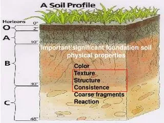
IMPORTANT SOIL PROPERTIES
550 likes | 667 Vues
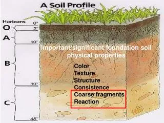
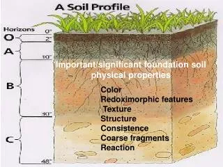
IMPORTANT SOIL PROPERTIES. By: Abdul Jabbar. Important Properties. Color Texture Structure Consistence Shrink-swell Potential Bulk Density Porosity Permeability. Infiltration Drainage Depth Available Water Holding Capacity Reaction Cation Exchange Capacity Landscape Position.

IMPORTANT SOIL PROPERTIES
E N D
Presentation Transcript
IMPORTANT SOIL PROPERTIES By: Abdul Jabbar
Important Properties • Color • Texture • Structure • Consistence • Shrink-swell Potential • Bulk Density • Porosity • Permeability • Infiltration • Drainage • Depth • Available Water Holding Capacity • Reaction • Cation Exchange Capacity • Landscape Position
SOIL COLOR • Useful tool for providing information about other soil properties • Organic matter content • Soil minerals • Seasonal high water tables Appling Series, Granville Co, NC
SOIL COLOR • Useful tool for providing information about other soil properties • Organic matter content • Soil minerals • Seasonal high water tables High Low Englehard Series, Hyde Co, NC
SOIL COLOR • Useful tool for providing information about other soil properties • Organic matter content • Soil minerals • Seasonal high water tables Red color - hematite (iron) Georgeville Series, Randolph Co, NC
SOIL COLOR • Useful tool for providing information about other soil properties • Organic matter content • Soil minerals • Seasonal high water tables Creedmoor Series, Chatham Co, NC
SOIL COLOR • Munsell Color Chart • Used to identify the soil color. This chart allows soil scientists to uniformly describe soil color. In the field, soil scientists compare the colors found in the soil with the color chips found on the chart.
SOIL COLOR • Redoximorphic Features • Soil colors formed by the repeated chemical oxidation and reduction of iron and manganese compounds resulting from saturation. • Useful for predicting the presence and depth of seasonal high water tables in the soil. Mattaponi Series, Chatham Co, NC
Redoximorphic Features • Redoximorphic Depletions • Low-chroma (gray) zones from which iron and manganese oxide or a combination of iron and manganese oxide and clay have been removed. These zones are indications of the chemical reduction of iron resulting from saturation. Creedmoor Series, Chatham Co, NC
Redoximorphic Features • Redoximorphic Concentrations • Nodules, concretions, soft masses, pore linings, and other features resulting from the accumulation of iron or manganese oxide. An indication of chemical reduction and oxidation resulting from saturation. Creedmoor Series, Chatham Co, NC
Redoximorphic Features • Reduced Matrix • Low-chroma (gray) horizons from which most iron oxide has been removed by leaching. These horizons are indications of the chemical reduction of iron resulting from long-term saturation. Cid Series, Chatham Co, NC
Texture • The relative proportions of sand, silt, and clay particles in a mass of soil. Used by soil scientists
Texture Triangle • Used by soil scientists to define the basic textural classes • Field soil scientists frequently estimate the texture by feel using their hands. • For more exact measurements there are laboratory techniques that can determine the exact amount of sand, silt, and clay.
Texture • Soils containing large amounts of sand exhibit little plasticity and cannot retain large amounts of water or nutrients. They have large voids between the particles and can readily transport water and air. Seabrook Series, Hyde Co, NC
Texture • The properties of silt are intermediate between sand and clay. Silty soils can retain large amounts of water but tend to have moderately slow to slow permeabilities. Soils high in silt can present problems for engineers since they will shift under stress and slide and flow when wet. Callison Series, Anson Co, NC
Texture • Clays exert a great influence on soil chemical and physical properties. Clay particles are chemically active and the proportion of clay-sized particles greatly influences soil physical properties, including aggregation, porosity, water movement and storage, aeration and workability of the soil. Vance Series, Granville Co, NC
Structure • The arrangement of primary soil particles into compound particles or aggregates. • The type and grade of structure plays an important role in the movement of water within soils.
Structure • There are eight structural types commonly recognized in soil profiles: Granular, single grain, blocky, prismatic, columnar, platy, wedge, and massive.
Structure • Granular - Rounded aggregates usually less than 1/4 inch in diameter. These rounded complexes lie loosely on the surface and are readily shaken apart. The aggregates are called granules and the pattern is called granular. This is the most common type of structure found in topsoil.
Structure • Single grain – Each individual soil particle is separate and there is essentially no structure. This is only found in very sandy soils and is the type of structure commonly seen in sand dunes at the beach.
Structure • Blocky - The original aggregates have been reduced to blocks, irregularly faced, and basically equal in height, width, and depth. Blocky structure is the most common type of structure seen in the subsoil (B horizon)
Structure • Prismatic – Characterized by vertical oriented aggregates or pillars with flat tops. These elongated columns vary in length with different soils. Prismatic structure is commonly seen in soils with high clay content and in horizons dominated by high shrink-swell clays.
Structure • Columnar–Characterized by vertical oriented aggregates or pillars with rounded tops. These elongated columns with flat tops vary in length with different soils. Most commonly seen in soils that have a high sodium content in a dry climate.
Structure • Platy – The aggregates are arranged in thin horizontal plates or sheets. This structure is commonly found in soil layers that have been compacted. Platy structure inhibits the downward movement of water.
Structure • Wedge – The aggregates resemble wedges, thinner at one end and thicker on the other. This structure is seen in soils with a high clay content that is dominated by expansive clays such as montmorillonite. (clays)
Structure • Affects permeability by influencing the path by which water can flow through the soil. The type of structure determines the number of interconnected macropores, which readily permit downward movement of water.
Consistence • The degree and kind of cohesion and adhesion that soil exhibits, and/or the resistance of soil to deformation or rupture under applied stress. Field evaluations of consistence usually include rupture resistance, stickiness, and plasticity.
Consistence • Rupture resistance is a measure of the soil’s ability to withstand applied stress. For this test, moist soil is normally used. A naturally occurring soil aggregate is placed between the thumb and index finger. Pressure is slowly applied to estimate the amount of force that is required to rupture a soil aggregate.
Consistence • Stickiness is the capacity of a soil to adhere to other objects. Stickiness is estimated at the moisture content that displays the greatest adherence when pressed between the thumb and forefinger. This normally occurs when the soil is quite wet.
Consistence • Plasticity is the degree to which a reworked soil can be permanently deformed without rupturing. Plasticity is evaluated by forming a roll (wire) of soil that is 4 cm long.
Shrink-swell Potential • Shrink-swell potential is a measurement of the amount of volume change that can occur when a soil wets and dries. Most of this volume change is due to the clay fraction of the soil. Clays swell when wet and shrink when dry. Soils high in 2:1 clays such as montmorillonite tend to have high shrink-swell potentials. Soils high in 1:1 clays such as kaolinite tend to have low shrink-swell potentials.
Shrink-swell Potential • A soil with a highshrink-swell potential can cause severe problems when used for urban development unless the problem is recognized and proper engineering precautions taken. Shrinking and swelling can buckle roads, crack building foundations and walls, and even damage plant roots.
Shrinkage limit • The shrinkage limit (SL) is the water content where further loss of moisture will not result in any more volume reduction. Plastic limit • The plastic limit (PL) is the water content where soil transitions between brittle and plastic behavior. • A thread of soil is at its plastic limit when it begins to crumble when rolled to a diameter of 3 mm. Liquid limit • The liquid limit (LL) is the water content at which a soil changes from plastic to liquid behavior. • The original liquid limit test of Atterberg's involved mixing a pat of clay in a round-bottomed porcelain bowl of 10-12cm diameter. • A groove was cut through the pat of clay with a spatula, and the bowl was then struck many times against the palm of one hand.
Liquid Limit Plastic Limit
Bulk Density • Bulk density is the mass of dry soil per unit volume, including the air space. • Bulk density has a major effect on the movement of air and water in soils. • Soils with high bulk densities are often compacted.
Bulk Density • Soil compaction restricts rooting depth, which reduces the uptake of water and nutrients by plants. No Compaction Compaction (plow pan)
Bulk Density • Compaction also decreases infiltration, thereby increasing runoff and the hazard of water erosion.
Permeability refers to the movement of air and water within the soil. Permeability rate is the rate at which a saturated soil transmits water, usually expressed in inches per hour. Texture, structure, bulk density, and the type and connectivity of macropores influence permeability. Hydraulic conductivity is a measurement of the amount of water that can move downward through a unit area of unsaturated soil in a unit of time. Saturated hydraulic conductivity (ksat) is a measurement of the amount of water that can move downward through a unit area of saturated soil in a unit of time. Permeability
Infiltration • Infiltration is the downward entry of water into the immediate surface of the soil and is influenced by texture, structure, bulk density, and the type and connectivity of macro-pores.
Drainage • Drainage refers to the frequency and duration of periods of saturation or partial saturation. Internal soil drainage is important because of its effect on land use and management decisions.
Drainage • An apparent water table is a type of saturation in which all horizons between the upper boundary of saturation and below are saturated. • Apparent water tables are frequently encountered in low-lying areas where the slope of the land is insufficient to provide good drainage such as flood plains, depressions, and nearly level areas. Saturated Zone Hydeland Series, Hyde Co, NC
Apparent Water Table Unsaturated Seasonal High Water Table Saturated
Drainage • A perched water table is a water table in a soil in which saturated layers are underlain by one or more unsaturated layers . • Often caused by a restrictive layer that has slow or very slow permeability. • Common in soils that have clayey subsoils and poor structure. Saturated Zone Unsaturated Zone Helena Series, Wake Co, NC
Perched Water Table Unsaturated Seasonal High Water Table Saturated Aquatard Unsaturated
Drainage • The depth to soil water tables fluctuates throughout the year. Most of this is due to rainfall variability and seasonal changes in the rate of evapotranspiration.
Reaction • Reaction is a measure of acidity or alkalinity of a soil. Acidity or alkalinity is determined by the amount of hydrogen and hydroxyl ions in the soil. When hydrogen ions outnumber hydroxyl ions the soil is acidic. In the reverse condition the soil is basic. A pH scale is used to measure the level of acidity or alkalinity.
Reaction • In NC, the natural soil pH will range from 4.0 to 8.0 with most soils tending to be acidic with pH values of 4.5 to 6.0. • In order to optimize plant growth, farmers and homeowners commonly adjust the pH of a soil by adding soil amendments such as lime. The amount of lime that needs to be added should be determined by a soil test.