Implementation of Model Data Interoperability for IOOS: Successes and Lessons Learned
290 likes | 477 Vues
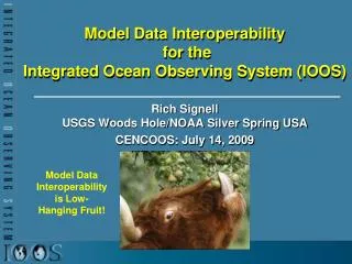
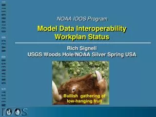
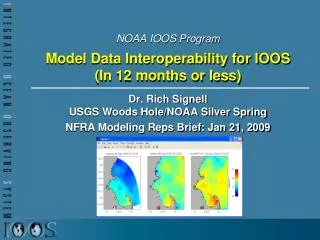
Implementation of Model Data Interoperability for IOOS: Successes and Lessons Learned. Rich Signell USGS Woods Hole, MA / NOAA Silver Spring USA. Model Data Interoperability is Low-Hanging Fruit!. US Integrated Ocean Observing System (IOOS ® ). IOOS ® Plan defines: Global Component

Implementation of Model Data Interoperability for IOOS: Successes and Lessons Learned
E N D
Presentation Transcript
Implementation of Model Data Interoperability for IOOS: Successes and Lessons Learned Rich Signell USGS Woods Hole, MA / NOAA Silver Spring USA Model Data Interoperability is Low-Hanging Fruit!
US Integrated Ocean Observing System (IOOS®) • IOOS® Plan defines: • Global Component • Coastal Component • 17 Federal Agencies • 11 Regional Associations
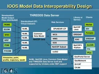
DMAC approved services for Gridded Data and Model Outputs satellite HF radar gridded model outputs Table of Contents Data Provider OPeNDAP/CF OGC WCS (Web Coverage Service) Data Values Quality Control Metadata CF Metadata
The Problem: Stovepiped Model Access ChesROMS Model Wen Long, UMaryland UCLA/JPL ROMS SCB Model Yi Chao, JPL
Result: Inability to compare and assess model results & underutilization of model products The GoMOOS Nowcast/Forecast Circulation Model (University of Maine)
Issue: Ocean grids are not regularly spaced! Curvilinear orthogonal horizontal coordinates Stretched surface and terrain following vertical coordinates
Climate and Forecast (CF) Metadata Conventions Groups adopting CF: GO-ESSP: Global Organization for Earth System Science Portal IOOS-DMAC: Integrated Ocean Observing System ESMF: Earth System Modeling Framework OGC: Open Geospatial Consortium (via WCS netcdf encoding)
NJ Toolkit for Matlabhttp://njtbx.sourceforge.net • Objective: Make it simple to access CF data • Example function: • [t, geo]=nj_tslice(URI,’temp’,1); • t = 22x120x180 single • geo = • lat: [120x180 single] • lon: [120x180 single] • z: [22x120x180 double] • time: 733582 (matlabdatenum) • nj_tslice works identically for ROMS, POM, ECOM, WRF, Wavewatch3 • URI can be: local NetCDF, remote NetCDF, NcML, OpenDAP Data URL • Coding by Sachin Kumar Bhate MSSTATE
Comparing Models with Data in Matlab Model 1: UMASS-ECOM Model 2: UMAINE-POM Data: SST 2008-Sep-08 07:32
Single Point of Access Catalog:GEO-IDE => IOOS Regions http://ferret.pmel.noaa.gov/thredds/geoideCatalog.html
Working with Data in ArcGIS using the NOAA/ASA Environmental Data Connector
14 Different Ocean Forecast Models Spanning CONUS Waters in IDV
Successes • Existing Unidata technology allowed for standards-based delivery of aggregated geospatial data from native model grids that put little or no effort on the data provider • Demonstrated interoperability with 17 THREDDS servers in 11 IOOS Regions • What did we get? • Single point of access for regional model results • Interoperable software • More eyes on the model results • More usage of model results • Faster feedback to modelers • Improved models • Increased community support for standards-based access
What Next? • Continue work on a high-level scientific toolbox for standardized access to model data. (Matlab toolbox based on NetCDF-Java) • Develop unstructured grid support: Common Data Model implemented in NetCDF-Java with methods comparable to structured grid • Applications need to be modified to read standardized data via OPeNDAP instead of home-grown files • Work on discovery and documentation
Lessons Learned • Honor the existing practices • Users are best served by developing infrastructure for Developers • Focus on success: find something that works, clone it, and build off it
Questions, Feedback? Dr. Richard P. Signell+1 (508) 457-2229rsignell@usgs.gov
Role of Regions • Develop customized THREDDS catalogs for regional users • Report status of services (e.g. NetCheck) • Assess and help with gridded data standards compliance following UAF-developed techniques • Develop end-user applications that access gridded data, using CF-compliant OPeNDAP • Help educate regional scientists, developers, consultants that standardized services, libraries and tools are available
THREDDS • When people say “THREDDS”, they can mean a catalog or a data server • THREDDS Catalogs are XML files that define metadata, datasets and services • THREDDS Data Server is a Java data server application developed by Unidata, a simple and flexible way for delivering CF-compliant data via OPeNDAP
OPeNDAP • When people say “OPeNDAP”, they can mean protocol, a server, or an organization • OPeNDAP (or just DAP) protocol: a remote data access service protocol with multiple responses • DDS – describes the format of the data • DAS – describes associated attributes • DDX – XML response containing the DDS & DAS • DODS – the actual data • OPeNDAP server: a server capable of serving the DAP protocol (e.g. THREDDS Data Server, Hyrax, Pydap, GrADS Data Server) • OPeNDAP organization: Defines and maintains the DAP protocol, develops servers and clients, provide custom OPeNDAP solutions